General Information
Internal Identifier CG_G4_U_b_3cm_b
| Soil Type | Chernozem |
|---|
| Classification | WRB |
|---|
|
| Location | Bernburg (Westerfeld) |
|---|
| Latitude | 51.820 |
|---|
| Longitude | 11.700 |
|---|
|
| Landuse | agricultural crop rotation |
|---|
| Tillage | reduced tillage |
|---|
| Crop | winter wheat, maize, winter wheat, winter rape, winter barley |
|---|
|
| Sampling Depth | 31.0 |
|---|
| Sample Height | 3.0 |
|---|
| Sampling Date | March 28, 2017 |
|---|
| Voxel size | 0.02 |
|---|
| Pores white? | True |
|---|
|
| XY Plane |
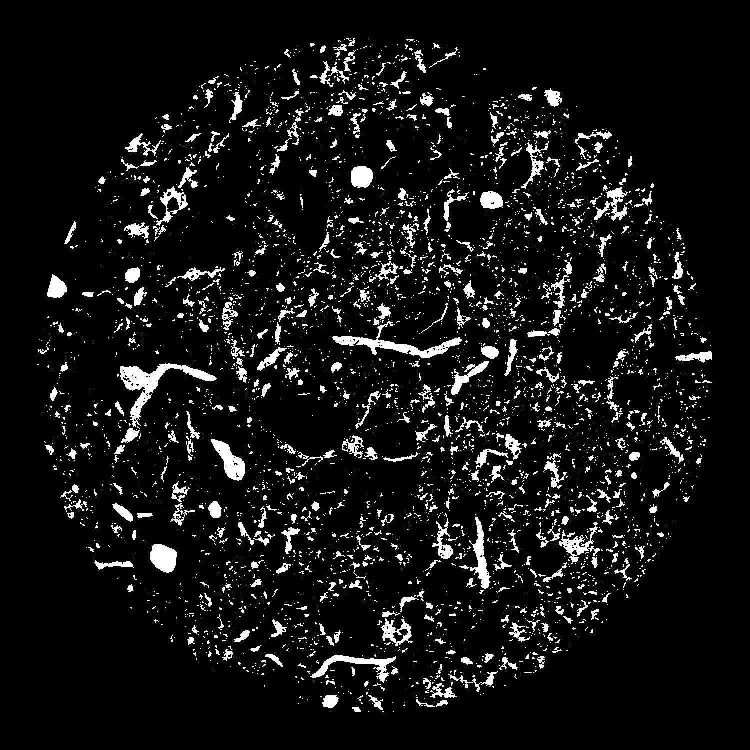
|
|---|
|
| XY Plane Grey |
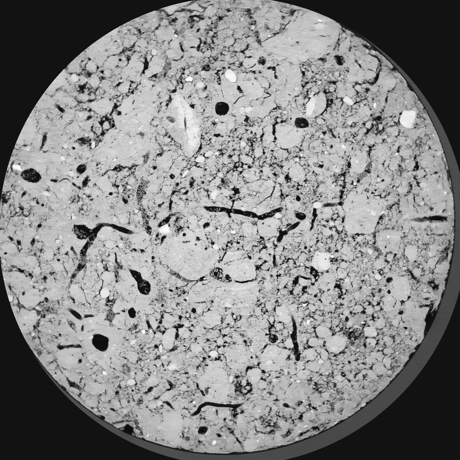
|
|---|
|
| Texture | silt loam |
|---|
| Sand | 8.0 |
|---|
| Silt | 79.0 |
|---|
| Clay | 13.0 |
|---|
|
| Bulk density | 1.41 |
|---|
| org. Carbon | 0.126 |
|---|
| six month after last tillage, field trial running for 25 years, only bottom 400 are dense, top looks as if aggregated |
|---|
| Publication |
|---|
| Binary File Download |
|---|
|
Results
| Porosity | Surface | Mean Curvature | Euler | MeanPoreSize | Gamma | PoreDist |
| 0.1001 | 2.969 | 4.8725 | 24.4875 | 0.0 | 0.7518 | 0.118024135 |
| Opening size | Volume | Surface | MeanCurvature | Euler number |
|---|
| 0.04 | 0.1001 | 2.969 | 4.8725 | 24.4875 |
| 0.05 | 0.09331 | 2.3425 | 2.8625 | 4.23875 |
| 0.06 | 0.08774 | 2.028 | 2.2155 | 2.35875 |
| 0.07 | 0.08373 | 1.8355 | 1.90075 | 2.93 |
| 0.08 | 0.0816 | 1.744 | 1.837 | 4.49875 |
| 0.09000000000000001 | 0.07046 | 1.3135 | 1.17925 | 2.355 |
| 0.1 | 0.06609 | 1.1715 | 1.00925 | 2.0675 |
| 0.12000000000000001 | 0.06079 | 1.0045 | 0.82925 | 1.77375 |
| 0.13999999999999999 | 0.05076 | 0.7345 | 0.537 | 1.057375 |
| 0.16 | 0.04511 | 0.603 | 0.41475 | 0.7819 |
| 0.18 | 0.03751 | 0.44405 | 0.272 | 0.5272125 |
| 0.19999999999999998 | 0.03405 | 0.37805 | 0.218925 | 0.377225 |
| 0.22 | 0.02845 | 0.28295 | 0.147625 | 0.27155 |
| 0.24 | 0.02588 | 0.24085 | 0.1188 | 0.1797875 |
| 0.26 | 0.02264 | 0.1945 | 0.089225 | 0.13725 |
| 0.28 | 0.02115 | 0.1728 | 0.075825 | 0.0962675 |
| 0.30000000000000004 | 0.01863 | 0.1414 | 0.0582 | 0.07254375 |
| 0.4 | 0.01186 | 0.0661 | 0.02130425 | 0.026665 |
| 0.5 | 0.008449 | 0.035005 | 0.00815225 | 0.01137175 |
| 0.6 | 0.006972 | 0.024305 | 0.004388 | 0.00372525 |
| 0.7000000000000001 | 0.005696 | 0.0167 | 0.002399825 | 0.002548875 |
| 0.9 | 0.004341 | 0.010235 | 0.000960725 | 0.0015685 |
| 1.1 | 0.003858 | 0.00901 | 0.00085875 | 0.000392125 |
| 1.3 | 0.003409 | 0.00803 | 0.000803875 | 0.000784263 |
| 1.5 | 0.002654 | 0.006145 | 0.0005882 | 0.000196062 |
| 1.7 | 0.002015 | 0.005075 | 0.00059995 | 0.000139712 |
| 1.9 | 0.0003541 | 0.001005 | 0.00014901 | 0.000069857 |
Reference: An open Soil Structure Library based on X-ray CT data
 Soil Structure Library