General Information
Internal Identifier UFZ_CT_01
| Soil Type | Luvisol |
|---|
| Classification | WRB |
|---|
|
| Location | Luettewitz |
|---|
| Latitude | 51.1183 |
|---|
| Longitude | 13.2286 |
|---|
|
| Landuse | agricultural crop rotation |
|---|
| Tillage | conventional tillage |
|---|
| Crop | winter wheat, sugar beet, winter wheat |
|---|
|
| Sampling Depth | 10.0 |
|---|
| Sample Height | 10.0 |
|---|
| Sampling Date | March 27, 2018 |
|---|
| Voxel size | 0.06 |
|---|
| Pores white? | True |
|---|
|
| XY Plane |
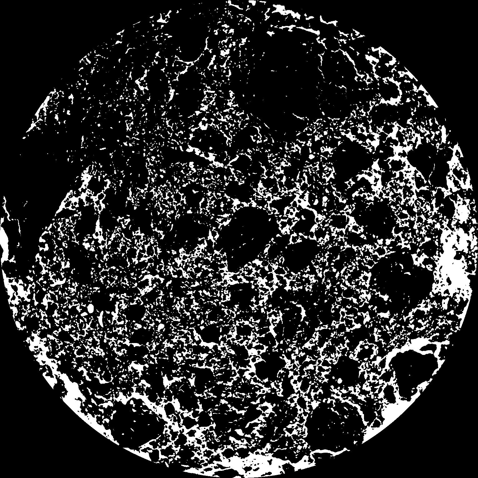
|
|---|
|
| XY Plane Grey |
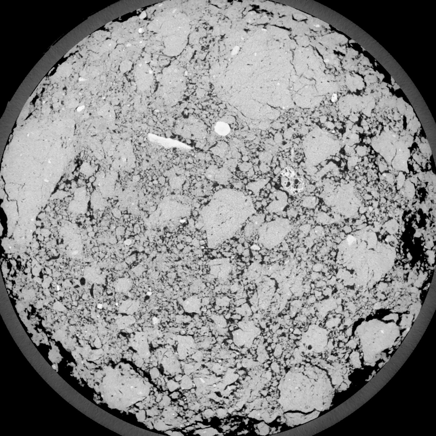
|
|---|
|
| Texture | silt loam |
|---|
| Sand | 18.0 |
|---|
| Silt | 78.0 |
|---|
| Clay | 4.0 |
|---|
|
| Bulk density | 1.41 |
|---|
| org. Carbon | 12.1 |
|---|
| six month after last tillage, field trial running for 26 years |
|---|
| Binary File Download |
|---|
|
Results
| Porosity | Surface | Mean Curvature | Euler | MeanPoreSize | Gamma | PoreDist |
| 0.1796 | 1.5615 | 0.518055556 | -0.468055556 | 0.0 | 0.9191 | 0.308936986 |
| Opening size | Volume | Surface | MeanCurvature | Euler number |
|---|
| 0.12 | 0.1796 | 1.5615 | 0.518055556 | -0.468055556 |
| 0.15 | 0.1753 | 1.44 | 0.424166667 | -0.509259259 |
| 0.18 | 0.1702 | 1.346833333 | 0.366111111 | -0.51712963 |
| 0.21 | 0.1642 | 1.2575 | 0.329722222 | -0.386018519 |
| 0.24 | 0.1608 | 1.210666667 | 0.33 | -0.188796296 |
| 0.27 | 0.1387 | 0.959833333 | 0.252472222 | -0.079861111 |
| 0.3 | 0.1273 | 0.844333333 | 0.223916667 | 0.000458856 |
| 0.36 | 0.1115 | 0.688833333 | 0.185138889 | 0.076851852 |
| 0.42 | 0.08452 | 0.454666667 | 0.113833333 | 0.068333333 |
| 0.48 | 0.07015 | 0.343666667 | 0.081305556 | 0.05162037 |
| 0.54 | 0.05311 | 0.2245 | 0.046138889 | 0.029943519 |
| 0.6000000000000001 | 0.04638 | 0.181833333 | 0.034888889 | 0.020907407 |
| 0.6599999999999999 | 0.03625 | 0.124333333 | 0.020566667 | 0.011530093 |
| 0.72 | 0.03199 | 0.101316667 | 0.015252778 | 0.0072125 |
| 0.78 | 0.02709 | 0.078666667 | 0.010669444 | 0.004618009 |
| 0.8400000000000001 | 0.02508 | 0.069483333 | 0.008975 | 0.00331787 |
| 0.8999999999999999 | 0.02153 | 0.0554 | 0.006544444 | 0.002200139 |
| 1.2 | 0.01278 | 0.026216667 | 0.002500778 | 0.000664769 |
| 1.5 | 0.008157 | 0.014146667 | 0.00117325 | 0.000270606 |
| 1.8 | 0.005512 | 0.008381667 | 0.000642056 | 0.000147069 |
| 2.1 | 0.003656 | 0.004778333 | 0.000321917 | 0.000082361 |
| 2.7 | 0.001862 | 0.001811667 | 0.000087536 | 0.000017648 |
| 3.3000000000000003 | 0.001228 | 0.0009895 | 0.000034239 | 0.000004339 |
| 3.9 | 0.0008644 | 0.000645333 | 0.000021531 | 0.000001735 |
| 4.5 | 0.000707 | 0.0005335 | 0.00001906 | 0.000001735 |
| 5.1 | 0.0005094 | 0.000389 | 0.000015178 | 0.000001735 |
| 5.699999999999999 | 0.000428 | 0.000337167 | 0.000013766 | 0.000001735 |
| 6.3 | 0.0003461 | 0.000288 | 0.000012707 | 0.000001735 |
Reference: An open Soil Structure Library based on X-ray CT data
 Soil Structure Library