General Information
Internal Identifier UFZ_CT_03
| Soil Type | Luvisol |
|---|
| Classification | WRB |
|---|
|
| Location | Luettewitz |
|---|
| Latitude | 51.1183 |
|---|
| Longitude | 13.2286 |
|---|
|
| Landuse | agricultural crop rotation |
|---|
| Tillage | conventional tillage |
|---|
| Crop | winter wheat, sugar beet, winter wheat |
|---|
|
| Sampling Depth | 10.0 |
|---|
| Sample Height | 10.0 |
|---|
| Sampling Date | March 27, 2018 |
|---|
| Voxel size | 0.06 |
|---|
| Pores white? | True |
|---|
|
| XY Plane |
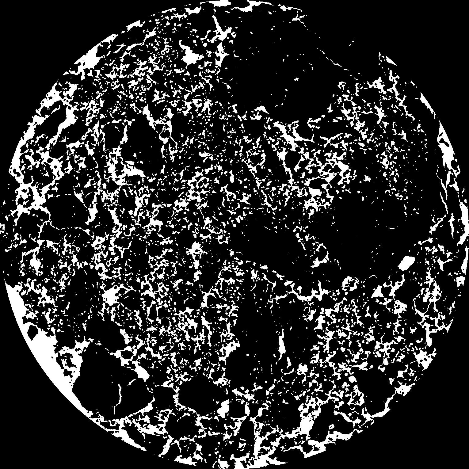
|
|---|
|
| XY Plane Grey |
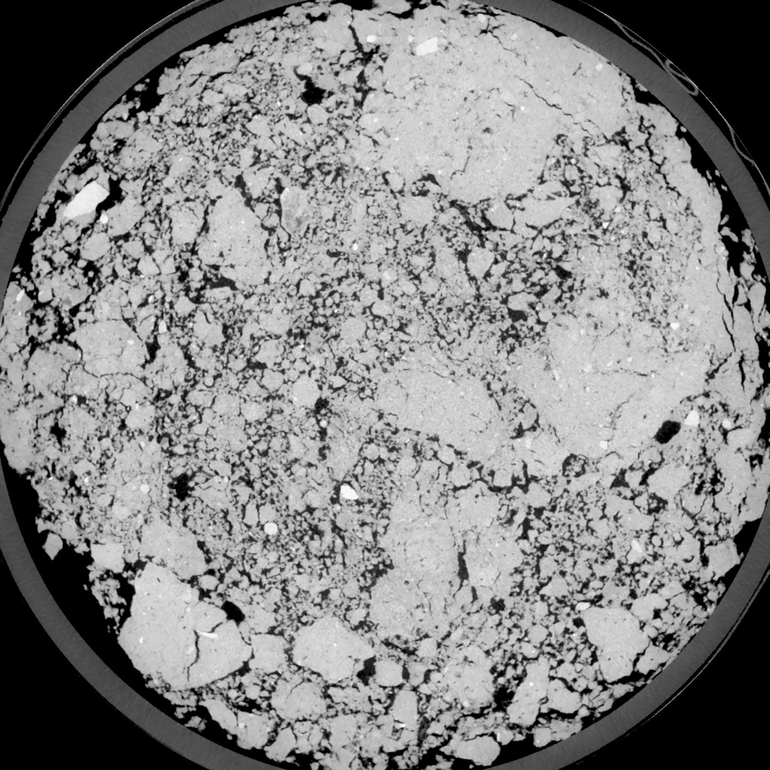
|
|---|
|
| Texture | silt loam |
|---|
| Sand | 18.0 |
|---|
| Silt | 78.0 |
|---|
| Clay | 4.0 |
|---|
|
| Bulk density | 1.3 |
|---|
| org. Carbon | 12.1 |
|---|
| six month after last tillage, field trial running for 26 years |
|---|
| Binary File Download |
|---|
|
Results
| Porosity | Surface | Mean Curvature | Euler | MeanPoreSize | Gamma | PoreDist |
| 0.212 | 1.6235 | 0.436944444 | -0.643055556 | 0.0 | 0.9632 | 0.336570987 |
| Opening size | Volume | Surface | MeanCurvature | Euler number |
|---|
| 0.12 | 0.212 | 1.6235 | 0.436944444 | -0.643055556 |
| 0.15 | 0.2085 | 1.525333333 | 0.371666667 | -0.609722222 |
| 0.18 | 0.2046 | 1.455666667 | 0.332777778 | -0.590277778 |
| 0.21 | 0.1998 | 1.387 | 0.308611111 | -0.465277778 |
| 0.24 | 0.1969 | 1.348 | 0.310277778 | -0.293194444 |
| 0.27 | 0.1777 | 1.1395 | 0.258361111 | -0.16712963 |
| 0.3 | 0.1669 | 1.034666667 | 0.238083333 | -0.070509259 |
| 0.36 | 0.1505 | 0.878833333 | 0.207138889 | 0.033997222 |
| 0.42 | 0.1204 | 0.631166667 | 0.144333333 | 0.061805556 |
| 0.48 | 0.1024 | 0.498 | 0.110333333 | 0.055601852 |
| 0.54 | 0.07948 | 0.343833333 | 0.069388889 | 0.040080556 |
| 0.6000000000000001 | 0.06968 | 0.283166667 | 0.054555556 | 0.029791204 |
| 0.6599999999999999 | 0.05437 | 0.197666667 | 0.034166667 | 0.018743056 |
| 0.72 | 0.0476 | 0.16115 | 0.026030556 | 0.012601389 |
| 0.78 | 0.03953 | 0.12305 | 0.018119444 | 0.008230093 |
| 0.8400000000000001 | 0.0362 | 0.107516667 | 0.01515 | 0.006118056 |
| 0.8999999999999999 | 0.03038 | 0.083516667 | 0.010741667 | 0.004041574 |
| 1.2 | 0.01737 | 0.038166667 | 0.003883333 | 0.001153056 |
| 1.5 | 0.01078 | 0.020466667 | 0.001783222 | 0.000447102 |
| 1.8 | 0.006823 | 0.011821667 | 0.0009615 | 0.000200019 |
| 2.1 | 0.004161 | 0.006576667 | 0.000495583 | 0.000117657 |
| 2.7 | 0.001531 | 0.00217 | 0.000153192 | 0.000029415 |
| 3.3000000000000003 | 0.0004046 | 0.000576333 | 0.000042358 | 0.000011766 |
| 3.9 | 0.00007777 | 0.000105427 | 0.000007413 | 0.000001678 |
Reference: An open Soil Structure Library based on X-ray CT data
 Soil Structure Library