General Information
Internal Identifier UFZ_CT_06
| Soil Type | Luvisol |
|---|
| Classification | WRB |
|---|
|
| Location | Luettewitz |
|---|
| Latitude | 51.1183 |
|---|
| Longitude | 13.2286 |
|---|
|
| Landuse | agricultural crop rotation |
|---|
| Tillage | conventional tillage |
|---|
| Crop | winter wheat, sugar beet, winter wheat |
|---|
|
| Sampling Depth | 10.0 |
|---|
| Sample Height | 10.0 |
|---|
| Sampling Date | March 27, 2018 |
|---|
| Voxel size | 0.06 |
|---|
| Pores white? | True |
|---|
|
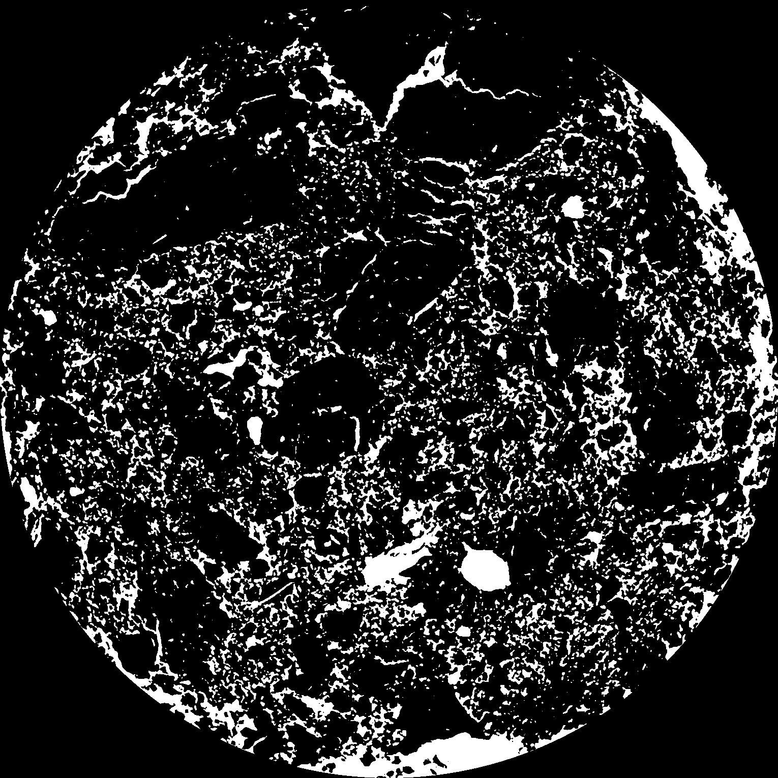
| XY Plane |
|
|---|
|
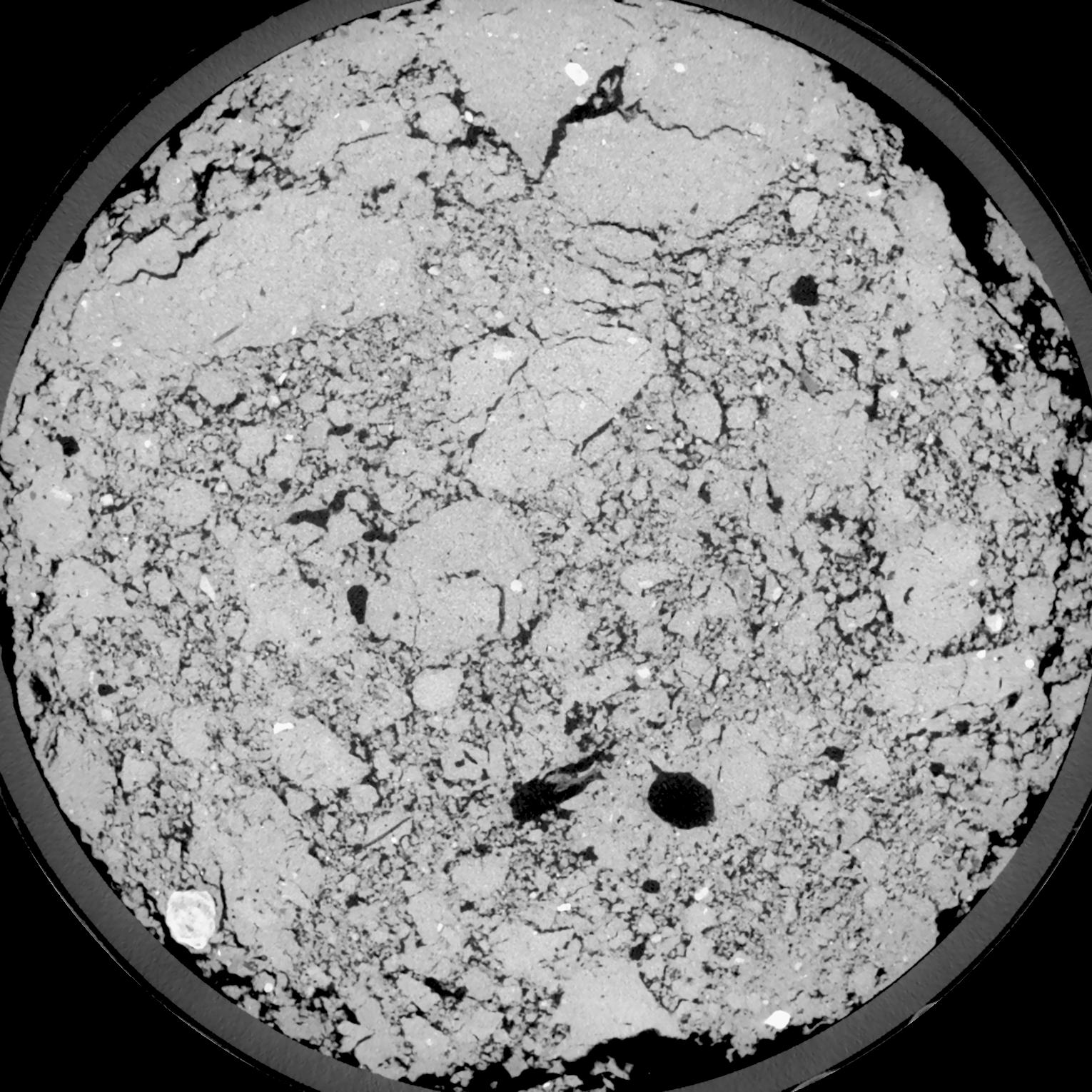
| XY Plane Grey |
|
|---|
|
| Texture | silt loam |
|---|
| Sand | 4.0 |
|---|
| Silt | 78.0 |
|---|
| Clay | 18.0 |
|---|
|
| Bulk density | 1.34 |
|---|
| org. Carbon | 12.1 |
|---|
| six month after last tillage, field trial running for 26 years |
|---|
| Binary File Download |
|---|
|
Results
| Porosity | Surface | Mean Curvature | Euler | MeanPoreSize | Gamma | PoreDist |
| 0.1643 | 1.43 | 0.518333333 | -0.209953704 | 0.0 | 0.9065 | 0.368960947 |
| Opening size | Volume | Surface | MeanCurvature | Euler number |
|---|
| 0.12 | 0.1643 | 1.43 | 0.518333333 | -0.209953704 |
| 0.15 | 0.1601 | 1.314166667 | 0.421944444 | -0.330462963 |
| 0.18 | 0.1554 | 1.226 | 0.361111111 | -0.364444444 |
| 0.21 | 0.1499 | 1.141 | 0.322222222 | -0.261018519 |
| 0.24 | 0.1467 | 1.097833333 | 0.320833333 | -0.087453704 |
| 0.27 | 0.1266 | 0.861166667 | 0.236 | -0.024818981 |
| 0.3 | 0.1162 | 0.754333333 | 0.205833333 | 0.037160648 |
| 0.36 | 0.1021 | 0.612166667 | 0.166388889 | 0.087453704 |
| 0.42 | 0.07843 | 0.403166667 | 0.098 | 0.063009259 |
| 0.48 | 0.06617 | 0.307833333 | 0.069027778 | 0.044143519 |
| 0.54 | 0.05173 | 0.207166667 | 0.039138889 | 0.02339537 |
| 0.6000000000000001 | 0.04607 | 0.171833333 | 0.030055556 | 0.015471296 |
| 0.6599999999999999 | 0.03736 | 0.12415 | 0.0189 | 0.009124074 |
| 0.72 | 0.03354 | 0.104383333 | 0.014769444 | 0.005788426 |
| 0.78 | 0.02895 | 0.084033333 | 0.011036111 | 0.004064907 |
| 0.8400000000000001 | 0.02696 | 0.075266667 | 0.009580556 | 0.003035463 |
| 0.8999999999999999 | 0.02335 | 0.061216667 | 0.007311111 | 0.002323657 |
| 1.2 | 0.01433 | 0.031183333 | 0.003205556 | 0.000923565 |
| 1.5 | 0.008975 | 0.016783333 | 0.001541028 | 0.000464722 |
| 1.8 | 0.005785 | 0.009365 | 0.000763083 | 0.000200009 |
| 2.1 | 0.003956 | 0.00561 | 0.000407306 | 0.000117653 |
| 2.7 | 0.002523 | 0.002943333 | 0.00015495 | 0.000035296 |
| 3.3000000000000003 | 0.001784 | 0.00201 | 0.000098828 | 0.000011765 |
| 3.9 | 0.0005093 | 0.000635667 | 0.000040236 | 0.000005883 |
Reference: An open Soil Structure Library based on X-ray CT data
 Soil Structure Library