General Information
Internal Identifier UFZ_CT_09
| Soil Type | Luvisol |
|---|
| Classification | WRB |
|---|
|
| Location | Luettewitz |
|---|
| Latitude | 51.1183 |
|---|
| Longitude | 13.2286 |
|---|
|
| Landuse | agricultural crop rotation |
|---|
| Tillage | conventional tillage |
|---|
| Crop | winter wheat, sugar beet, winter wheat |
|---|
|
| Sampling Depth | 10.0 |
|---|
| Sample Height | 10.0 |
|---|
| Sampling Date | March 27, 2018 |
|---|
| Voxel size | 0.06 |
|---|
| Pores white? | True |
|---|
|
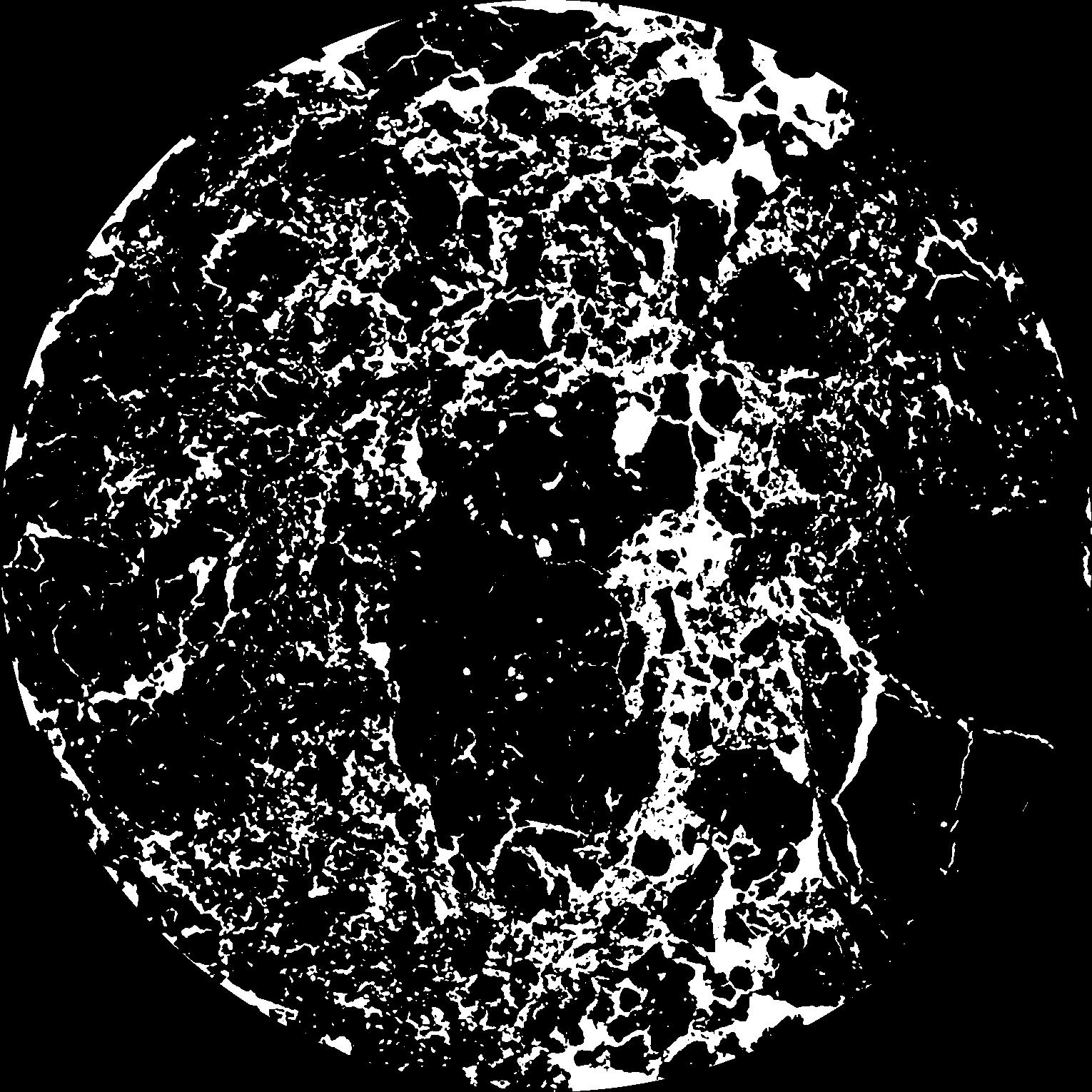
| XY Plane |
|
|---|
|
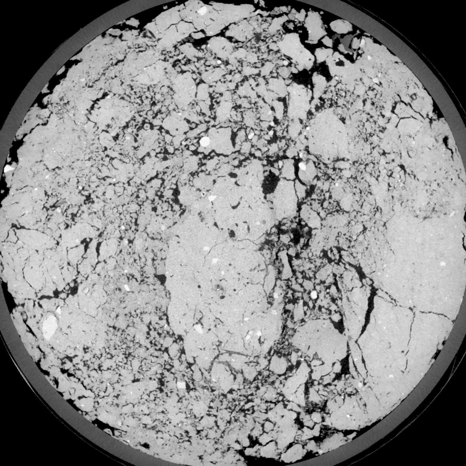
| XY Plane Grey |
|
|---|
|
| Texture | silt loam |
|---|
| Sand | 4.0 |
|---|
| Silt | 78.0 |
|---|
| Clay | 18.0 |
|---|
|
| Bulk density | 1.45 |
|---|
| org. Carbon | 12.1 |
|---|
| six month after last tillage, field trial running for 26 years |
|---|
| Binary File Download |
|---|
|
Results
| Porosity | Surface | Mean Curvature | Euler | MeanPoreSize | Gamma | PoreDist |
| 0.1461 | 1.163 | 0.393055556 | -0.013300926 | 0.0 | 0.883 | 0.429090312 |
| Opening size | Volume | Surface | MeanCurvature | Euler number |
|---|
| 0.12 | 0.1461 | 1.163 | 0.393055556 | -0.013300926 |
| 0.15 | 0.1428 | 1.0665 | 0.309722222 | -0.169444444 |
| 0.18 | 0.1389 | 0.993166667 | 0.2575 | -0.23212963 |
| 0.21 | 0.1346 | 0.927333333 | 0.225722222 | -0.181111111 |
| 0.24 | 0.1323 | 0.895333333 | 0.223944444 | -0.068842593 |
| 0.27 | 0.1175 | 0.725166667 | 0.164 | -0.058611111 |
| 0.3 | 0.11 | 0.650333333 | 0.145388889 | -0.016830556 |
| 0.36 | 0.09946 | 0.548333333 | 0.121444444 | 0.02580787 |
| 0.42 | 0.08071 | 0.394833333 | 0.081222222 | 0.028725463 |
| 0.48 | 0.06993 | 0.317166667 | 0.062694444 | 0.025372685 |
| 0.54 | 0.05599 | 0.227166667 | 0.040972222 | 0.019518981 |
| 0.6000000000000001 | 0.04988 | 0.190666667 | 0.032888889 | 0.014536574 |
| 0.6599999999999999 | 0.04017 | 0.138966667 | 0.0219 | 0.010530093 |
| 0.72 | 0.0358 | 0.1163 | 0.017294444 | 0.007165278 |
| 0.78 | 0.0304 | 0.09195 | 0.012755556 | 0.005400463 |
| 0.8400000000000001 | 0.02808 | 0.081466667 | 0.010891667 | 0.004035602 |
| 0.8999999999999999 | 0.02395 | 0.06505 | 0.008080556 | 0.00282963 |
| 1.2 | 0.01391 | 0.031033333 | 0.003272222 | 0.00103537 |
| 1.5 | 0.008365 | 0.015885 | 0.001450333 | 0.000447093 |
| 1.8 | 0.005307 | 0.008871667 | 0.000720417 | 0.000200014 |
| 2.1 | 0.003426 | 0.005133333 | 0.000370611 | 0.000082361 |
| 2.7 | 0.001504 | 0.00193 | 0.000116125 | 0.000017648 |
| 3.3000000000000003 | 0.0006654 | 0.000850667 | 0.000056122 | 0.000011766 |
| 3.9 | 0.0002716 | 0.000357667 | 0.000024708 | 0.000005206 |
Reference: An open Soil Structure Library based on X-ray CT data
 Soil Structure Library