General Information
Internal Identifier UFZ_CT_10
| Soil Type | Luvisol |
|---|
| Classification | WRB |
|---|
|
| Location | Luettewitz |
|---|
| Latitude | 51.1183 |
|---|
| Longitude | 13.2286 |
|---|
|
| Landuse | agricultural crop rotation |
|---|
| Tillage | conventional tillage |
|---|
| Crop | winter wheat, sugar beet, winter wheat |
|---|
|
| Sampling Depth | 10.0 |
|---|
| Sample Height | 10.0 |
|---|
| Sampling Date | March 27, 2018 |
|---|
| Voxel size | 0.06 |
|---|
| Pores white? | True |
|---|
|
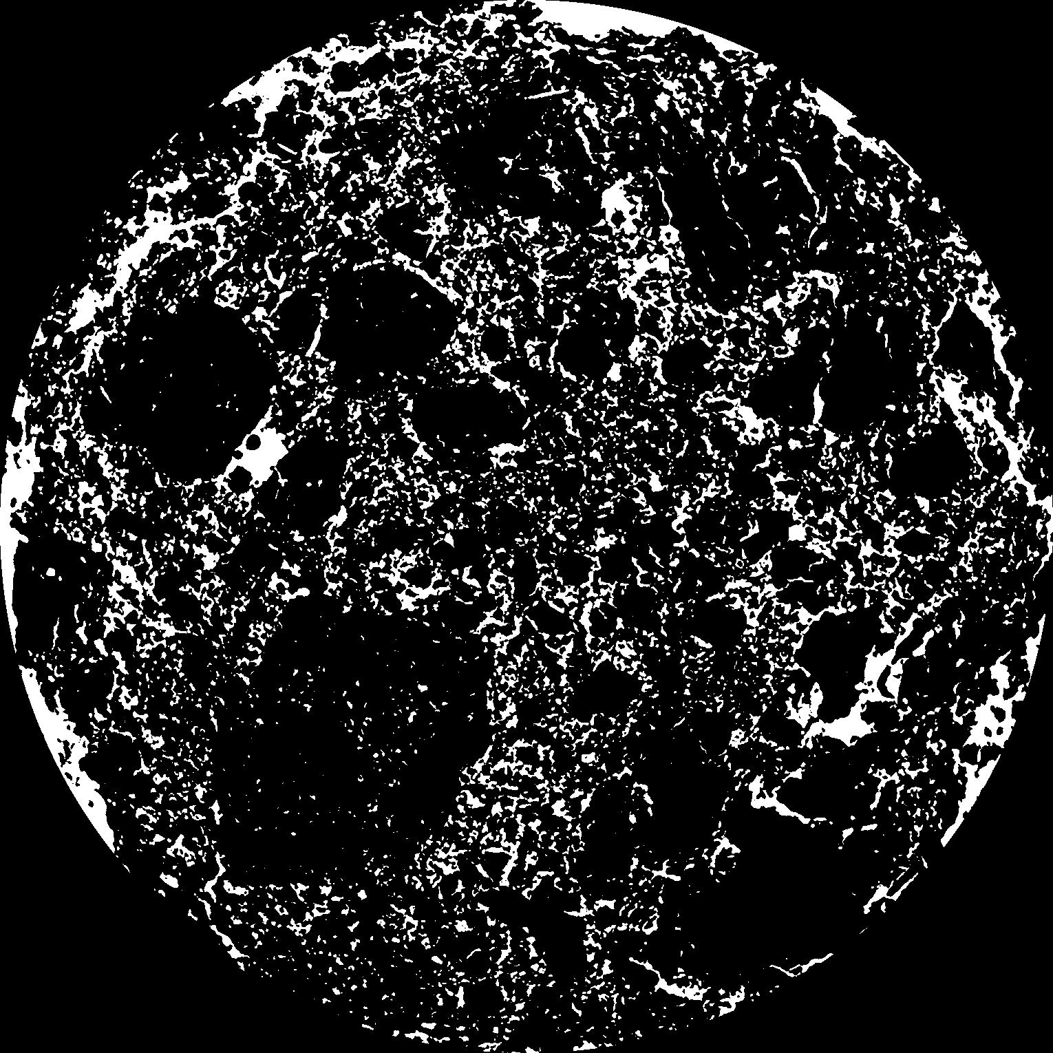
| XY Plane |
|
|---|
|
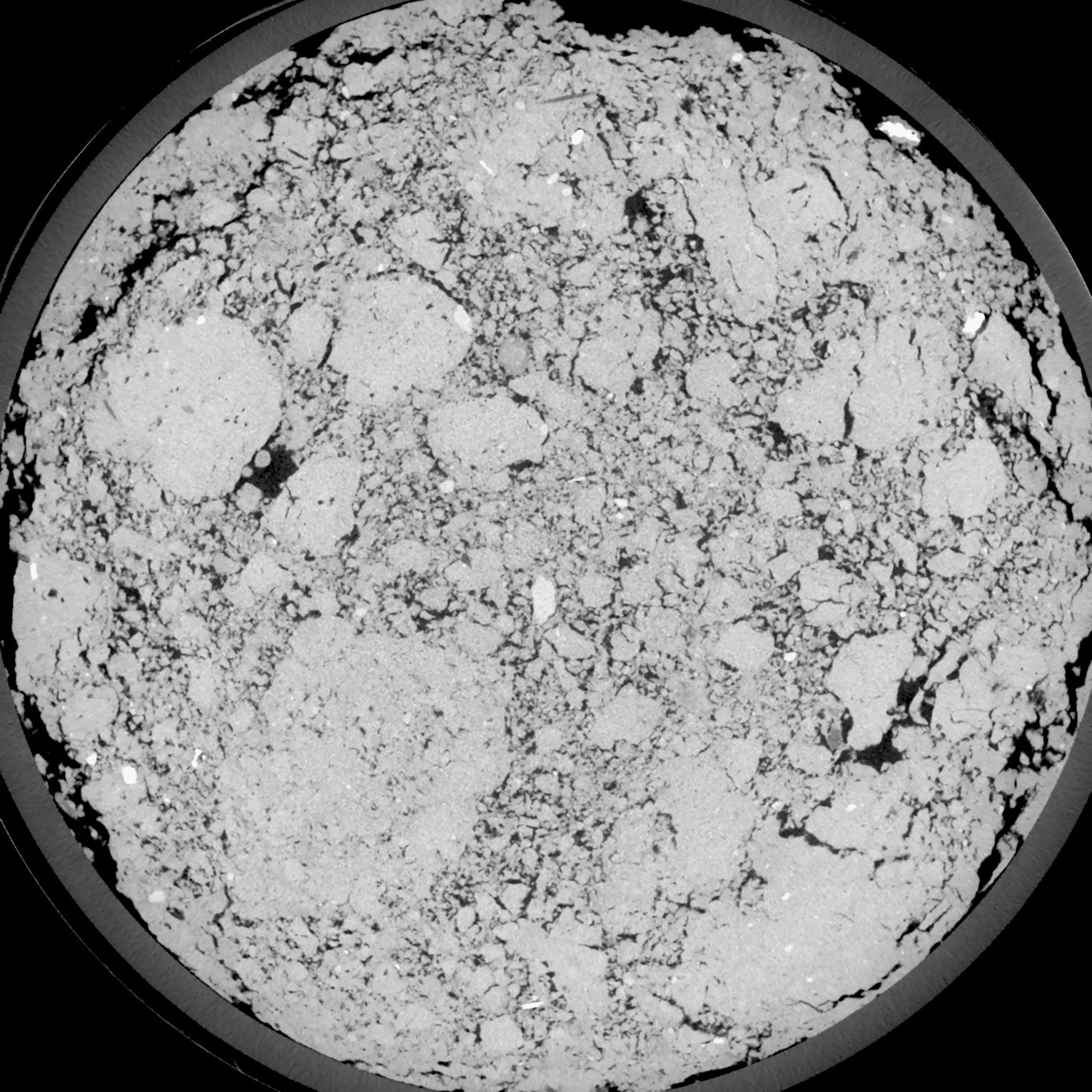
| XY Plane Grey |
|
|---|
|
| Texture | silt loam |
|---|
| Sand | 4.0 |
|---|
| Silt | 78.0 |
|---|
| Clay | 18.0 |
|---|
|
| Bulk density | 1.43 |
|---|
| org. Carbon | 12.1 |
|---|
| six month after last tillage, field trial running for 26 years |
|---|
| Binary File Download |
|---|
|
Results
| Porosity | Surface | Mean Curvature | Euler | MeanPoreSize | Gamma | PoreDist |
| 0.1477 | 1.407 | 0.557222222 | -0.083564815 | 0.0 | 0.8772 | 0.305524073 |
| Opening size | Volume | Surface | MeanCurvature | Euler number |
|---|
| 0.12 | 0.1477 | 1.407 | 0.557222222 | -0.083564815 |
| 0.15 | 0.1431 | 1.28 | 0.447222222 | -0.230648148 |
| 0.18 | 0.1378 | 1.180333333 | 0.377222222 | -0.278611111 |
| 0.21 | 0.1317 | 1.086833333 | 0.332777778 | -0.180138889 |
| 0.24 | 0.1284 | 1.041 | 0.33 | -0.010365278 |
| 0.27 | 0.1077 | 0.7925 | 0.233027778 | 0.018206944 |
| 0.3 | 0.09747 | 0.685333333 | 0.199833333 | 0.06287037 |
| 0.36 | 0.08389 | 0.547 | 0.1585 | 0.095925926 |
| 0.42 | 0.06178 | 0.349 | 0.090805556 | 0.062037037 |
| 0.48 | 0.05054 | 0.260666667 | 0.063194444 | 0.042884259 |
| 0.54 | 0.03749 | 0.1685 | 0.035027778 | 0.02244213 |
| 0.6000000000000001 | 0.03249 | 0.136833333 | 0.02665 | 0.015200926 |
| 0.6599999999999999 | 0.02488 | 0.094233333 | 0.016258333 | 0.008794444 |
| 0.72 | 0.02157 | 0.076666667 | 0.012366667 | 0.005559259 |
| 0.78 | 0.01769 | 0.058716667 | 0.008763889 | 0.003617824 |
| 0.8400000000000001 | 0.0161 | 0.0516 | 0.007516667 | 0.002811898 |
| 0.8999999999999999 | 0.0132 | 0.04005 | 0.005541667 | 0.002029491 |
| 1.2 | 0.006427 | 0.016356667 | 0.002001639 | 0.000700046 |
| 1.5 | 0.003256 | 0.007121667 | 0.000762028 | 0.000252954 |
| 1.8 | 0.001734 | 0.003413333 | 0.000334944 | 0.00009412 |
| 2.1 | 0.0008473 | 0.001448667 | 0.000121417 | 0.000035296 |
| 2.7 | 0.0003179 | 0.000529833 | 0.00004165 | 0.000004943 |
Reference: An open Soil Structure Library based on X-ray CT data
 Soil Structure Library