General Information
Internal Identifier UFZ_CT_12
| Soil Type | Luvisol |
|---|
| Classification | WRB |
|---|
|
| Location | Luettewitz |
|---|
| Latitude | 51.1183 |
|---|
| Longitude | 13.2286 |
|---|
|
| Landuse | agricultural crop rotation |
|---|
| Tillage | conventional tillage |
|---|
| Crop | winter wheat, sugar beet, winter wheat |
|---|
|
| Sampling Depth | 10.0 |
|---|
| Sample Height | 10.0 |
|---|
| Sampling Date | March 27, 2018 |
|---|
| Voxel size | 0.06 |
|---|
| Pores white? | True |
|---|
|
| XY Plane |
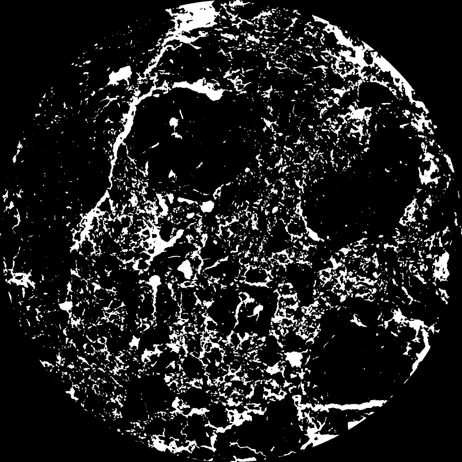
|
|---|
|
| XY Plane Grey |
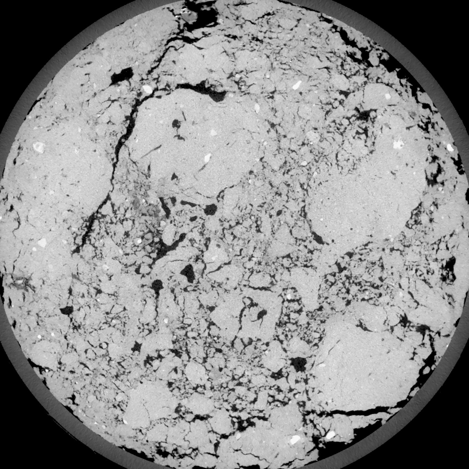
|
|---|
|
| Texture | silt loam |
|---|
| Sand | 4.0 |
|---|
| Silt | 78.0 |
|---|
| Clay | 18.0 |
|---|
|
| Bulk density | 1.54 |
|---|
| org. Carbon | 12.1 |
|---|
| six month after last tillage, field trial running for 26 years |
|---|
| Binary File Download |
|---|
|
Results
| Porosity | Surface | Mean Curvature | Euler | MeanPoreSize | Gamma | PoreDist |
| 0.1363 | 1.159 | 0.439722222 | 0.070092593 | 0.0 | 0.8654 | 0.385522992 |
| Opening size | Volume | Surface | MeanCurvature | Euler number |
|---|
| 0.12 | 0.1363 | 1.159 | 0.439722222 | 0.070092593 |
| 0.15 | 0.1327 | 1.061 | 0.351388889 | -0.107083333 |
| 0.18 | 0.1287 | 0.985 | 0.295555556 | -0.174027778 |
| 0.21 | 0.1242 | 0.915166667 | 0.260472222 | -0.122268519 |
| 0.24 | 0.1218 | 0.8815 | 0.25775 | -0.008353241 |
| 0.27 | 0.1063 | 0.698 | 0.186638889 | 0.001005926 |
| 0.3 | 0.09859 | 0.618166667 | 0.163027778 | 0.035166204 |
| 0.36 | 0.08796 | 0.512 | 0.13325 | 0.062824074 |
| 0.42 | 0.06985 | 0.355 | 0.083805556 | 0.047175926 |
| 0.48 | 0.05986 | 0.278833333 | 0.061888889 | 0.03600787 |
| 0.54 | 0.04757 | 0.1945 | 0.037805556 | 0.022512963 |
| 0.6000000000000001 | 0.04248 | 0.162716667 | 0.029722222 | 0.015994907 |
| 0.6599999999999999 | 0.03464 | 0.119183333 | 0.019258333 | 0.010247685 |
| 0.72 | 0.03118 | 0.100816667 | 0.015236111 | 0.006688426 |
| 0.78 | 0.02693 | 0.0813 | 0.011375 | 0.004835648 |
| 0.8400000000000001 | 0.02511 | 0.073033333 | 0.009880556 | 0.003582546 |
| 0.8999999999999999 | 0.02173 | 0.05955 | 0.007555556 | 0.002723657 |
| 1.2 | 0.01321 | 0.030116667 | 0.003191667 | 0.001035324 |
| 1.5 | 0.008336 | 0.016866667 | 0.001605611 | 0.000423551 |
| 1.8 | 0.005078 | 0.009161667 | 0.000784278 | 0.000182361 |
| 2.1 | 0.002972 | 0.004891667 | 0.000387194 | 0.000088241 |
| 2.7 | 0.001057 | 0.001586833 | 0.000121064 | 0.000029413 |
| 3.3000000000000003 | 0.0003353 | 0.000479333 | 0.00003565 | 0.000005883 |
| 3.9 | 0.00006341 | 0.000093583 | 0.000007412 | 0.000001797 |
Reference: An open Soil Structure Library based on X-ray CT data
 Soil Structure Library