General Information
Internal Identifier UFZ_NT_08
| Soil Type | Luvisol |
|---|
| Classification | WRB |
|---|
|
| Location | Luettewitz |
|---|
| Latitude | 51.1183 |
|---|
| Longitude | 13.2286 |
|---|
|
| Landuse | agricultural crop rotation |
|---|
| Tillage | no tillage |
|---|
| Crop | winter wheat, sugar beet, winter wheat |
|---|
|
| Sampling Depth | 10.0 |
|---|
| Sample Height | 10.0 |
|---|
| Sampling Date | March 27, 2018 |
|---|
| Voxel size | 0.06 |
|---|
| Pores white? | True |
|---|
|
| XY Plane |
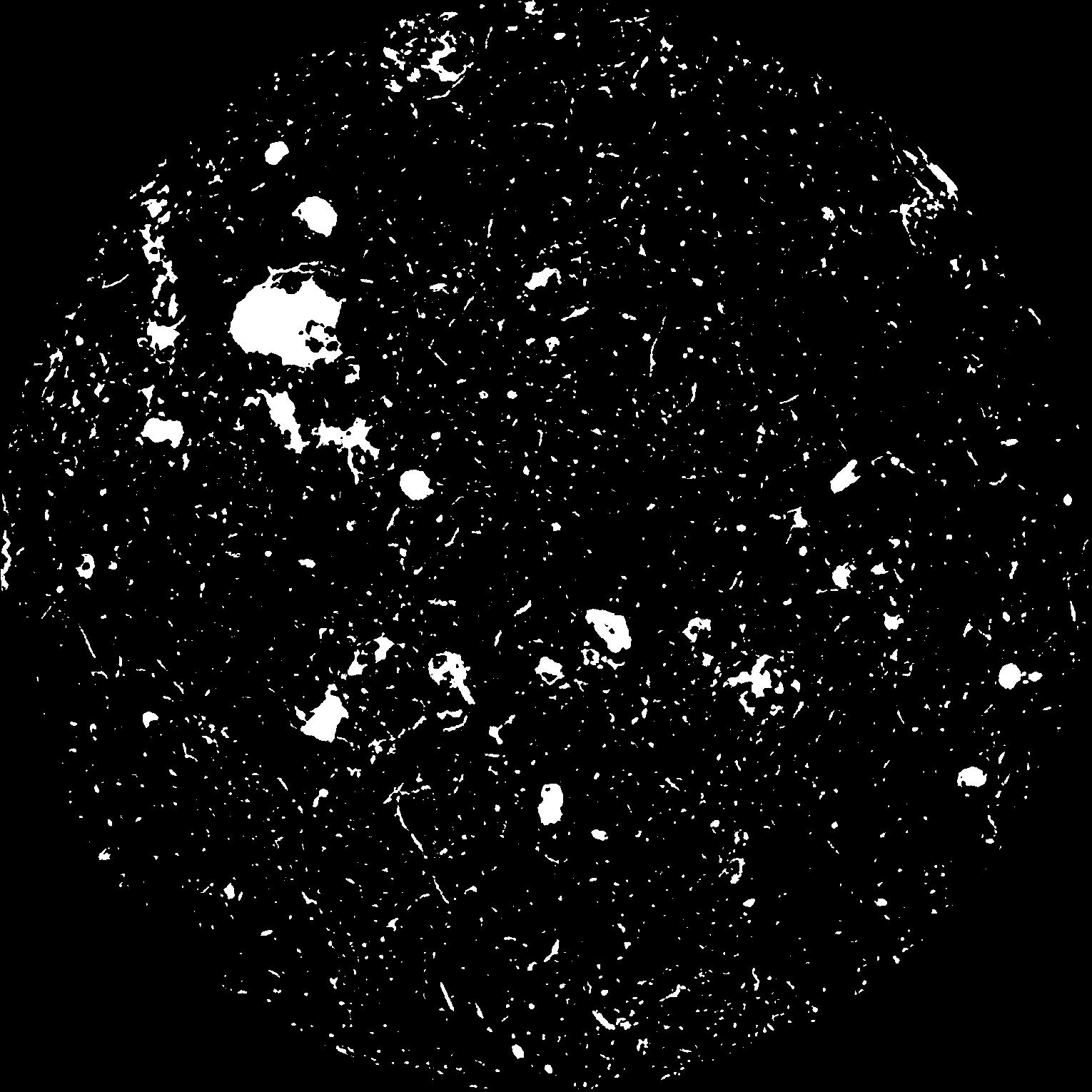
|
|---|
|
| XY Plane Grey |
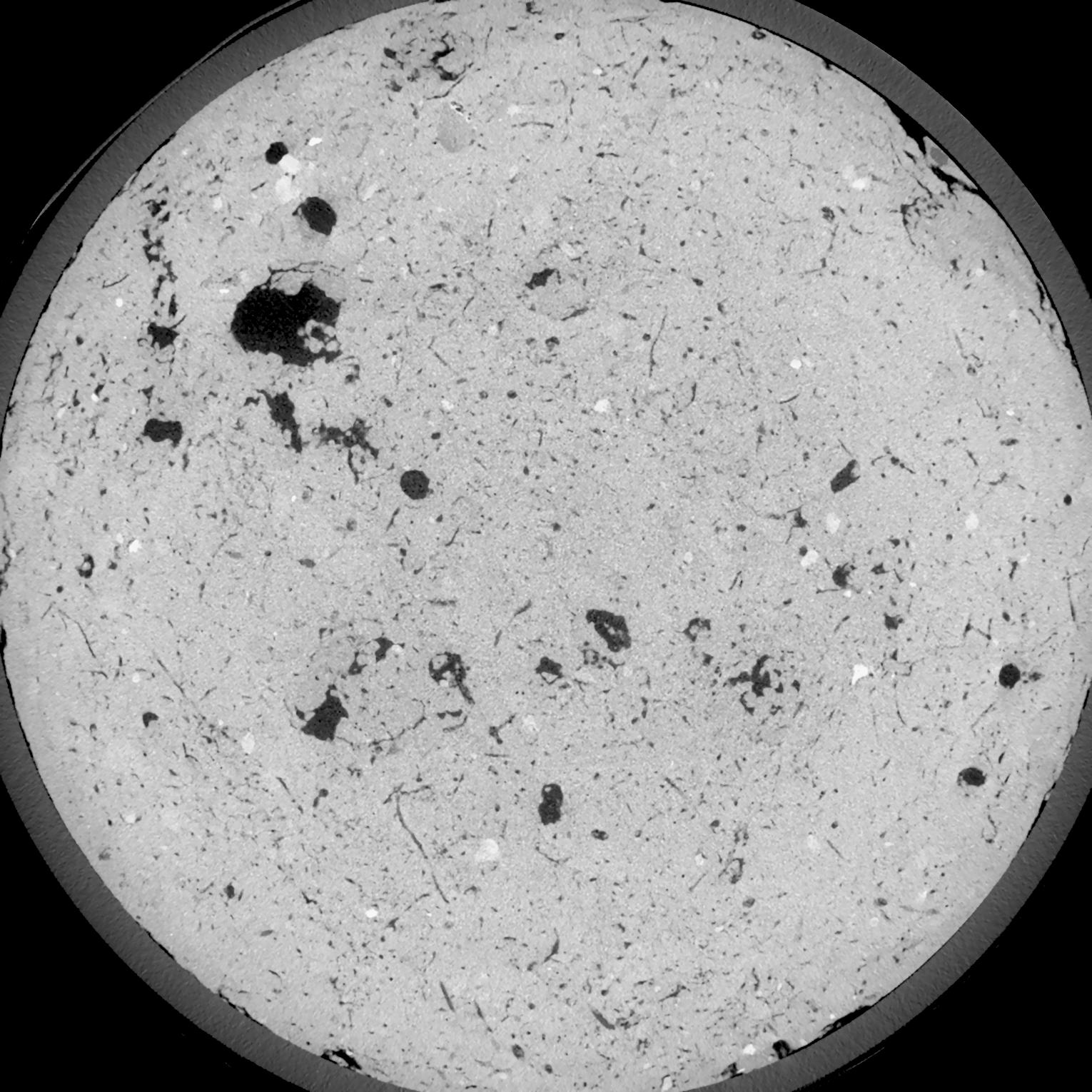
|
|---|
|
| Texture | silt loam |
|---|
| Sand | 3.0 |
|---|
| Silt | 77.0 |
|---|
| Clay | 20.0 |
|---|
|
| Bulk density | 1.58 |
|---|
| org. Carbon | 12.8 |
|---|
| six month after last tillage, field trial running for 26 years |
|---|
| Binary File Download |
|---|
|
Results
| Porosity | Surface | Mean Curvature | Euler | MeanPoreSize | Gamma | PoreDist |
| 0.05637 | 0.576 | 0.422222222 | 0.975 | 0.0 | 0.4786 | 0.362155532 |
| Opening size | Volume | Surface | MeanCurvature | Euler number |
|---|
| 0.12 | 0.05637 | 0.576 | 0.422222222 | 0.975 |
| 0.15 | 0.0528 | 0.480166667 | 0.298611111 | 0.466203704 |
| 0.18 | 0.04922 | 0.4 | 0.212194444 | 0.259490741 |
| 0.21 | 0.04589 | 0.338166667 | 0.16075 | 0.190462963 |
| 0.24 | 0.04457 | 0.318166667 | 0.153305556 | 0.229768519 |
| 0.27 | 0.03735 | 0.2095 | 0.075194444 | 0.081064815 |
| 0.3 | 0.03477 | 0.1775 | 0.057944444 | 0.061805556 |
| 0.36 | 0.0316 | 0.140916667 | 0.040527778 | 0.039901852 |
| 0.42 | 0.02739 | 0.099683333 | 0.022058333 | 0.016306481 |
| 0.48 | 0.02527 | 0.0824 | 0.016019444 | 0.010406481 |
| 0.54 | 0.02267 | 0.06405 | 0.010275 | 0.006053241 |
| 0.6000000000000001 | 0.02151 | 0.056683333 | 0.008352778 | 0.004311991 |
| 0.6599999999999999 | 0.01971 | 0.046733333 | 0.005916667 | 0.003247222 |
| 0.72 | 0.01886 | 0.042216667 | 0.004936111 | 0.002064815 |
| 0.78 | 0.01782 | 0.037533333 | 0.004019444 | 0.001664769 |
| 0.8400000000000001 | 0.01735 | 0.0354 | 0.003647222 | 0.001153009 |
| 0.8999999999999999 | 0.01645 | 0.031983333 | 0.003080556 | 0.000994167 |
| 1.2 | 0.01378 | 0.023316667 | 0.001944083 | 0.000605926 |
| 1.5 | 0.0115 | 0.0174 | 0.001298528 | 0.000394139 |
| 1.8 | 0.009491 | 0.013031667 | 0.000898972 | 0.000217657 |
| 2.1 | 0.007526 | 0.009115 | 0.000546389 | 0.000141185 |
| 2.7 | 0.005002 | 0.005036667 | 0.000242131 | 0.000035296 |
| 3.3000000000000003 | 0.003543 | 0.003175 | 0.000135889 | 0.000023531 |
| 3.9 | 0.002777 | 0.002441667 | 0.000103769 | 0.000011765 |
| 4.5 | 0.002158 | 0.001951667 | 0.000092828 | 0.000017648 |
| 5.1 | 0.001366 | 0.001197 | 0.000055767 | 0.000011765 |
| 5.699999999999999 | 0.0005596 | 0.000406833 | 0.00001553 | 0.000001797 |
| 6.3 | 0.0005162 | 0.0003825 | 0.000014824 | 0.000001797 |
| 6.8999999999999995 | 0.0004668 | 0.0003555 | 0.000014471 | 0.000001797 |
Reference: An open Soil Structure Library based on X-ray CT data
 Soil Structure Library