General Information
Internal Identifier UFZ_NT_11
| Soil Type | Luvisol |
|---|
| Classification | WRB |
|---|
|
| Location | Luettewitz |
|---|
| Latitude | 51.1183 |
|---|
| Longitude | 13.2286 |
|---|
|
| Landuse | agricultural crop rotation |
|---|
| Tillage | no tillage |
|---|
| Crop | winter wheat, sugar beet, winter wheat |
|---|
|
| Sampling Depth | 10.0 |
|---|
| Sample Height | 10.0 |
|---|
| Sampling Date | March 27, 2018 |
|---|
| Voxel size | 0.06 |
|---|
| Pores white? | True |
|---|
|
| XY Plane |
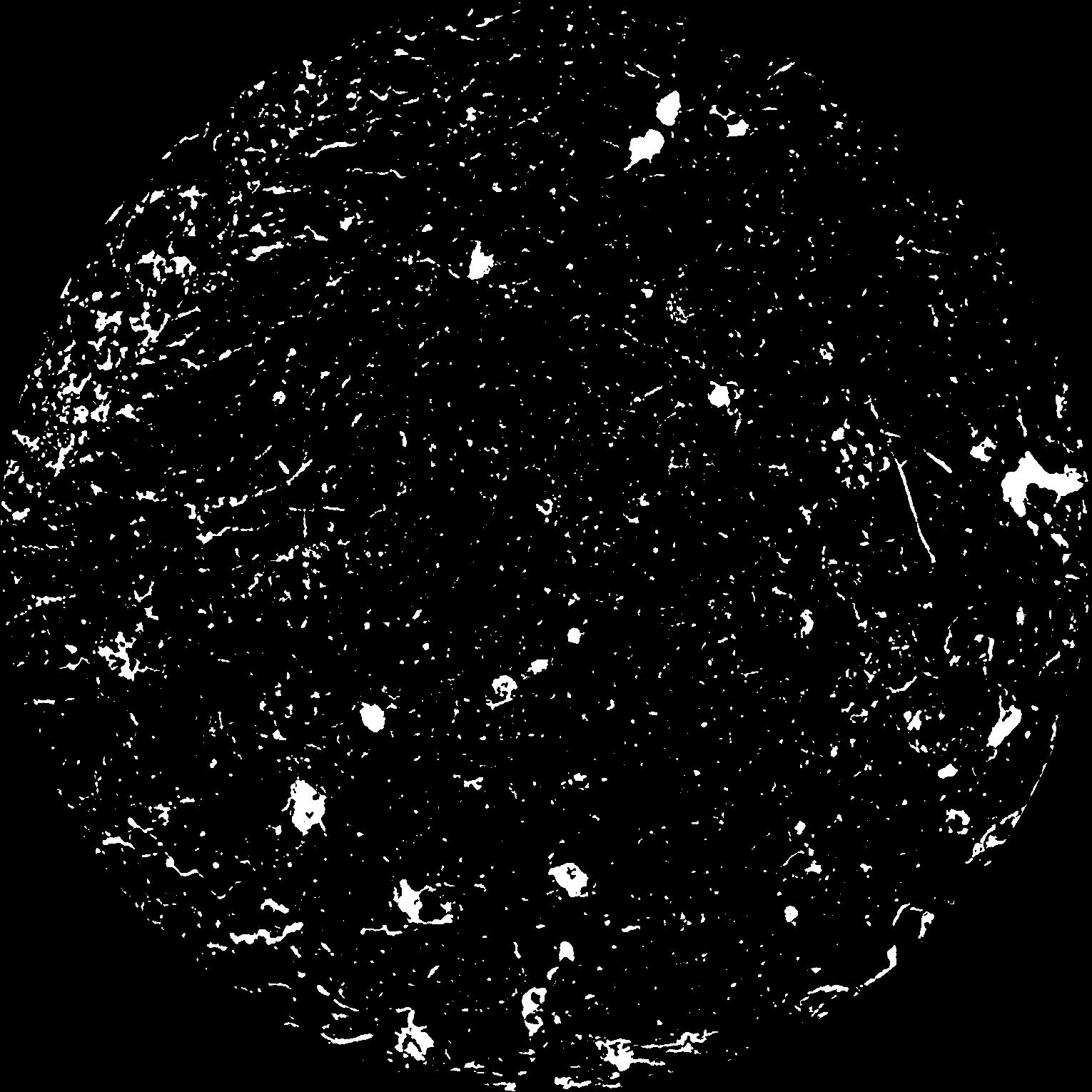
|
|---|
|
| XY Plane Grey |
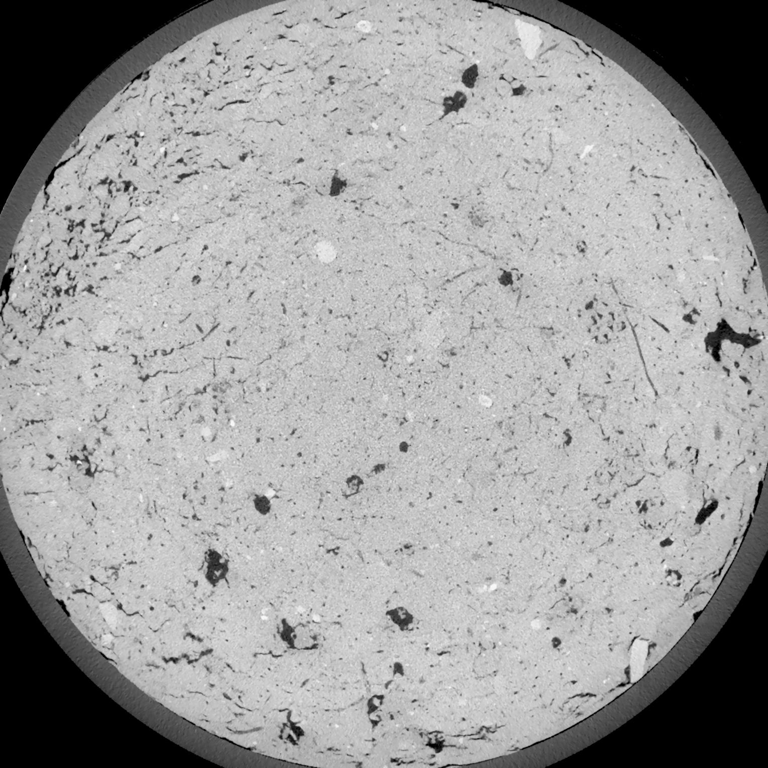
|
|---|
|
| Texture | silt loam |
|---|
| Sand | 3.0 |
|---|
| Silt | 77.0 |
|---|
| Clay | 20.0 |
|---|
|
| Bulk density | 1.58 |
|---|
| org. Carbon | 12.8 |
|---|
| six month after last tillage, field trial running for 26 years |
|---|
| Binary File Download |
|---|
|
Results
| Porosity | Surface | Mean Curvature | Euler | MeanPoreSize | Gamma | PoreDist |
| 0.06751 | 0.664666667 | 0.420277778 | 0.874537037 | 0.0 | 0.6219 | 0.364661964 |
| Opening size | Volume | Surface | MeanCurvature | Euler number |
|---|
| 0.12 | 0.06751 | 0.664666667 | 0.420277778 | 0.874537037 |
| 0.15 | 0.06408 | 0.573166667 | 0.306388889 | 0.393333333 |
| 0.18 | 0.06063 | 0.498666667 | 0.230861111 | 0.211342593 |
| 0.21 | 0.05716 | 0.436833333 | 0.183777778 | 0.164166667 |
| 0.24 | 0.05567 | 0.414833333 | 0.177111111 | 0.214027778 |
| 0.27 | 0.04674 | 0.288333333 | 0.095555556 | 0.083611111 |
| 0.3 | 0.04326 | 0.247 | 0.0755 | 0.067453704 |
| 0.36 | 0.03884 | 0.198166667 | 0.054555556 | 0.047037037 |
| 0.42 | 0.03257 | 0.13965 | 0.030805556 | 0.020930093 |
| 0.48 | 0.02934 | 0.1143 | 0.022680556 | 0.013847222 |
| 0.54 | 0.0253 | 0.08665 | 0.01455 | 0.008358796 |
| 0.6000000000000001 | 0.02353 | 0.0756 | 0.011719444 | 0.005676389 |
| 0.6599999999999999 | 0.02074 | 0.060716667 | 0.008327778 | 0.004329491 |
| 0.72 | 0.01943 | 0.053916667 | 0.006919444 | 0.002717731 |
| 0.78 | 0.01776 | 0.046666667 | 0.005616667 | 0.002276528 |
| 0.8400000000000001 | 0.01699 | 0.0432 | 0.005011111 | 0.001523565 |
| 0.8999999999999999 | 0.01559 | 0.037866667 | 0.004180556 | 0.001370602 |
| 1.2 | 0.01145 | 0.024316667 | 0.002379944 | 0.000847083 |
| 1.5 | 0.008394 | 0.016255 | 0.001480611 | 0.000464722 |
| 1.8 | 0.005824 | 0.010413333 | 0.000900361 | 0.000235301 |
| 2.1 | 0.003759 | 0.006285 | 0.000526611 | 0.000152944 |
| 2.7 | 0.001443 | 0.002031667 | 0.000150708 | 0.000041177 |
| 3.3000000000000003 | 0.0005197 | 0.000616 | 0.000038119 | 0.000005882 |
| 3.9 | 0.0002436 | 0.000249833 | 0.000012706 | 0.000001864 |
| 4.5 | 0.0001422 | 0.000163847 | 0.000009883 | 0.000001864 |
Reference: An open Soil Structure Library based on X-ray CT data
 Soil Structure Library