General Information
Internal Identifier ML_I361
| Soil Type | Regosol |
|---|
| Classification | WRB |
|---|
|
| Location | Garzweiler open-cast mine |
|---|
| Latitude | 51.063893 |
|---|
| Longitude | 6.502039 |
|---|
|
| Landuse | agricultural crop rotation |
|---|
| Tillage | conventional tillage |
|---|
| Crop | winter wheat, maize, winter barley, triticale, winter wheat |
|---|
|
| Sampling Depth | 21.0 |
|---|
| Sample Height | 0.7 |
|---|
| Sampling Date | March 15, 2017 |
|---|
| Voxel size | 0.005 |
|---|
| Pores white? | True |
|---|
|
| XY Plane |
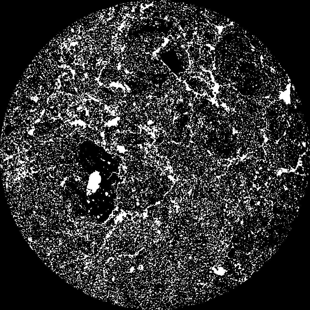
|
|---|
|
| XY Plane Grey |
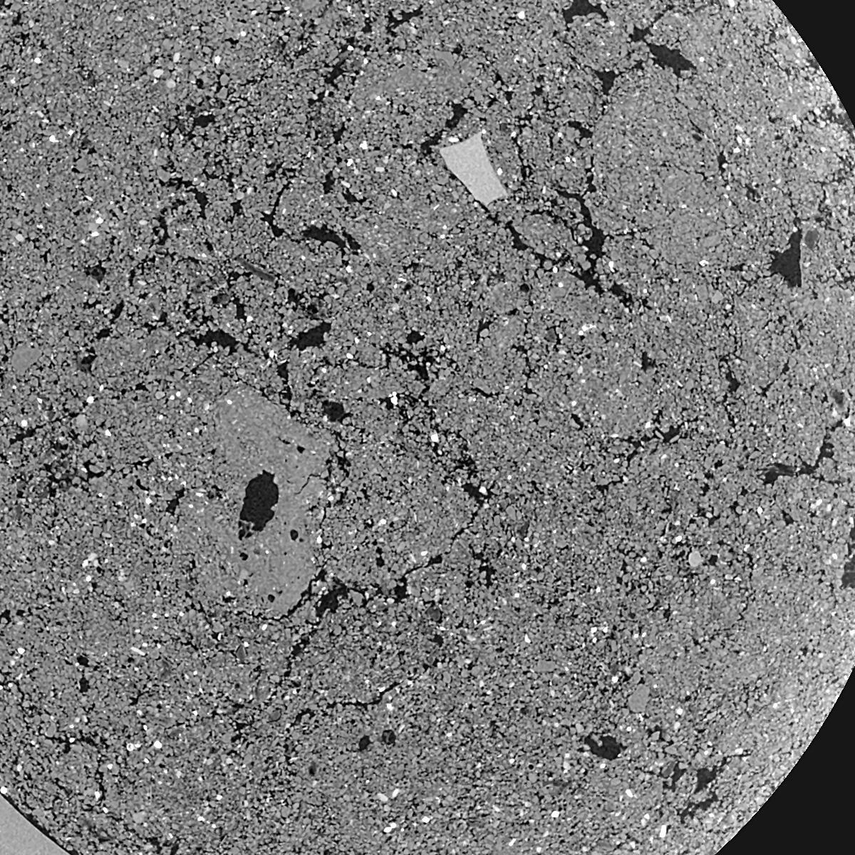
|
|---|
|
| Texture | silty clay loam |
|---|
| Sand | 3.5 |
|---|
| Silt | 65.1 |
|---|
| Clay | 31.4 |
|---|
|
|
Results
| Porosity | Surface | Mean Curvature | Euler | MeanPoreSize | Gamma | PoreDist |
| 0.2509 | 47.4 | 373.28 | -2703.2 | 0.0 | 0.8442 | 0.008469179 |
| Opening size | Volume | Surface | MeanCurvature | Euler number |
|---|
| 0.01 | 0.2509 | 47.4 | 373.28 | -2703.2 |
| 0.0125 | 0.2126 | 34.48 | 254.32 | -57.7824 |
| 0.015 | 0.1599 | 21.78 | 143.28 | 1021.6 |
| 0.0175 | 0.1298 | 15.368 | 91.2 | 1122.4 |
| 0.02 | 0.1194 | 13.516 | 85.52 | 1761.6 |
| 0.022500000000000003 | 0.08076 | 6.486 | 26.444 | 323.76 |
| 0.025 | 0.07071 | 5.062 | 18.236 | 211.12 |
| 0.030000000000000002 | 0.06243 | 3.974 | 12.952 | 154.72 |
| 0.034999999999999996 | 0.04927 | 2.492 | 5.896 | 49.288 |
| 0.04 | 0.04369 | 1.991 | 4.152 | 27.9104 |
| 0.045 | 0.03719 | 1.4848 | 2.63 | 16.236 |
| 0.049999999999999996 | 0.03444 | 1.2964 | 2.1628 | 11.7152 |
| 0.055 | 0.02979 | 1.0158 | 1.5336 | 8.504 |
| 0.06 | 0.02764 | 0.888 | 1.2552 | 6.09624 |
| 0.065 | 0.02483 | 0.746 | 0.9876 | 4.82624 |
| 0.07 | 0.02358 | 0.6822 | 0.8732 | 3.9016 |
| 0.07500000000000001 | 0.02115 | 0.5688 | 0.6528 | 2.70264 |
| 0.1 | 0.0152 | 0.3366 | 0.287336 | 0.792512 |
| 0.125 | 0.01127 | 0.2246 | 0.16714 | 0.314976 |
| 0.15 | 0.008204 | 0.15874 | 0.121264 | 0.172728 |
| 0.17500000000000002 | 0.00485 | 0.09828 | 0.090936 | 0.193048 |
| 0.225 | 0.0008003 | 0.01595 | 0.0157996 | 0.0406416 |
Reference: An open Soil Structure Library based on X-ray CT data
 Soil Structure Library