General Information
Internal Identifier Ad_2_A_1_u
| Soil Type | Haplic Luvisol |
|---|
| Classification | WRB |
|---|
|
| Location | Adenstedt |
|---|
| Latitude | 52.00772222 |
|---|
| Longitude | 9.939417 |
|---|
|
| Landuse | Cropland |
|---|
| Tillage | tillage |
|---|
| Crop | winter wheat, sugarbeets, winter wheat, silage mais |
|---|
|
| Sampling Depth | 10.0 |
|---|
| Sampling Date | March 24, 2021 |
|---|
| Voxel size | 0.06 |
|---|
| Pores white? | True |
|---|
|
| XY Plane |
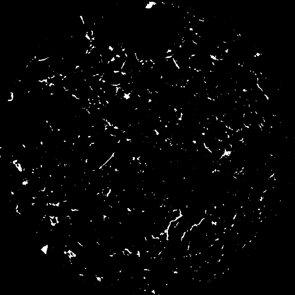
|
|---|
|
| XY Plane Grey |
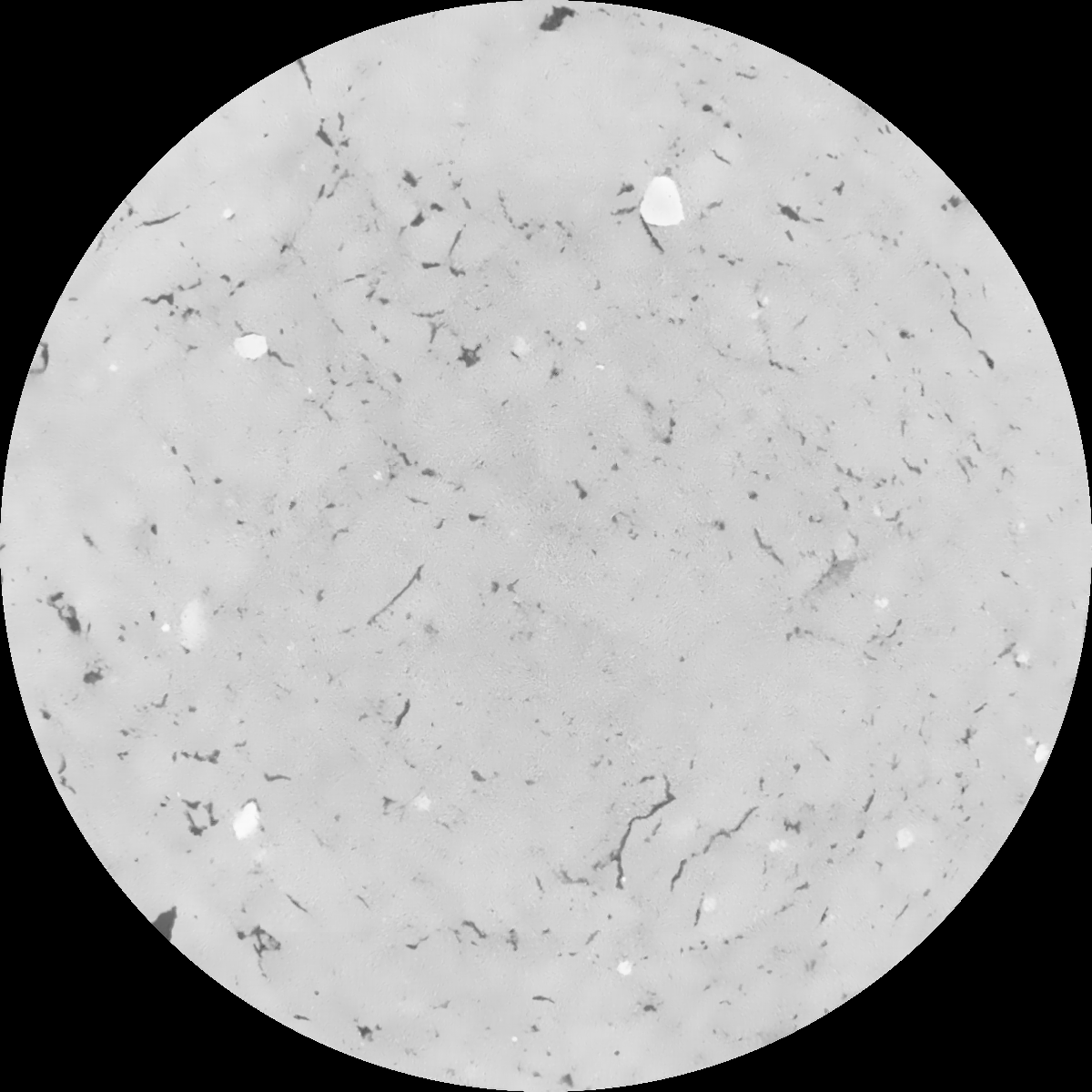
|
|---|
|
| Texture | clayey silt |
|---|
| Sand | 8.3 |
|---|
| Silt | 71.9 |
|---|
| Clay | 19.8 |
|---|
|
|
Results
| Porosity | Surface | Mean Curvature | Euler | MeanPoreSize | Gamma | PoreDist |
| 0.019326539 | 0.226681758 | 0.147892949 | 0.3485338 | 0.544002808096 | 0.00591213296891 | 0.747008284 |
| Opening size | Volume | Surface | MeanCurvature | Euler number |
|---|
| 0.12 | 0.019326539 | 0.226681758 | 0.147892949 | 0.3485338 |
| 0.15 | 0.01795921 | 0.188638829 | 0.099647102 | 0.14405416 |
| 0.18 | 0.01681554 | 0.165570038 | 0.079187949 | 0.091717235 |
| 0.21 | 0.015680831 | 0.146540452 | 0.066252708 | 0.07548595 |
| 0.24 | 0.015110941 | 0.138326847 | 0.063719069 | 0.085831257 |
| 0.27 | 0.011637348 | 0.091424258 | 0.035839947 | 0.040106275 |
| 0.3 | 0.010255889 | 0.075597062 | 0.028559011 | 0.033101853 |
| 0.36 | 0.008570376 | 0.057113046 | 0.020674483 | 0.022939542 |
| 0.42 | 0.00605663 | 0.032620103 | 0.009920499 | 0.009787891 |
| 0.48 | 0.00496325 | 0.023335437 | 0.006366261 | 0.005734284 |
| 0.54 | 0.003833085 | 0.01478639 | 0.003339502 | 0.002856908 |
| 0.6 | 0.003436642 | 0.012065855 | 0.002483464 | 0.001884139 |
| 0.66 | 0.002879449 | 0.008689075 | 0.001509685 | 0.001110017 |
| 0.72 | 0.002660285 | 0.007422896 | 0.001175462 | 0.000703091 |
| 0.78 | 0.002395132 | 0.00615561 | 0.000887403 | 0.000512871 |
| 0.84 | 0.002279802 | 0.00560285 | 0.000771882 | 0.000349138 |
| 0.9 | 0.002062385 | 0.004683086 | 0.000592783 | 0.00027931 |
| 1.2 | 0.001514071 | 0.002719971 | 0.000266279 | 0.000103537 |
| 1.5 | 0.001133643 | 0.001672762 | 0.000137717 | 0.000050565 |
| 1.8 | 0.000929106 | 0.001167376 | 0.000076787 | 0.000016855 |
| 2.1 | 0.000809579 | 0.000929088 | 0.000053414 | 0.000021671 |
| 2.7 | 0.000609213 | 0.000624324 | 0.000032613 | 0.000015651 |
| 3.3 | 0.000488702 | 0.000455833 | 0.000019918 | 0.000002408 |
| 3.9 | 0.000425661 | 0.000405732 | 0.000018668 | 0.000002408 |
| 4.5 | 0.00031906 | 0.000337479 | 0.00001755 | 0.000002408 |
| 5.1 | 0.0 | 0.0 | 0.0 | 0.0 |
| 5.7 | 0.0 | 0.0 | 0.0 | 0.0 |
| 6.3 | 0.0 | 0.0 | 0.0 | 0.0 |
| 6.9 | 0.0 | 0.0 | 0.0 | 0.0 |
| 7.5 | 0.0 | 0.0 | 0.0 | 0.0 |
| 8.1 | 0.0 | 0.0 | 0.0 | 0.0 |
| 8.7 | 0.0 | 0.0 | 0.0 | 0.0 |
| 9.3 | 0.0 | 0.0 | 0.0 | 0.0 |
| 9.9 | 0.0 | 0.0 | 0.0 | 0.0 |
Reference: An open Soil Structure Library based on X-ray CT data
 Soil Structure Library