General Information
Internal Identifier Ad_3_A_1_u
| Soil Type | Haplic Luvisol |
|---|
| Classification | WRB |
|---|
|
| Location | Adenstedt |
|---|
| Latitude | 52.00772222 |
|---|
| Longitude | 9.939417 |
|---|
|
| Landuse | Cropland |
|---|
| Tillage | tillage |
|---|
| Crop | winter wheat, sugarbeets, winter wheat, silage mais |
|---|
|
| Sampling Depth | 10.0 |
|---|
| Sampling Date | March 24, 2021 |
|---|
| Voxel size | 0.06 |
|---|
| Pores white? | True |
|---|
|
| XY Plane |
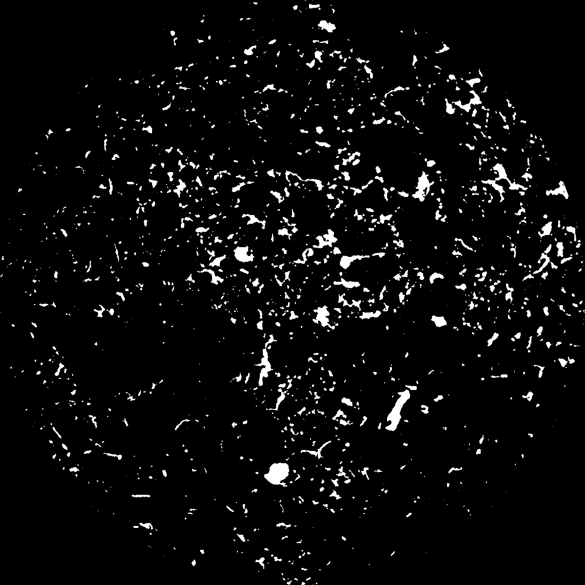
|
|---|
|
| XY Plane Grey |
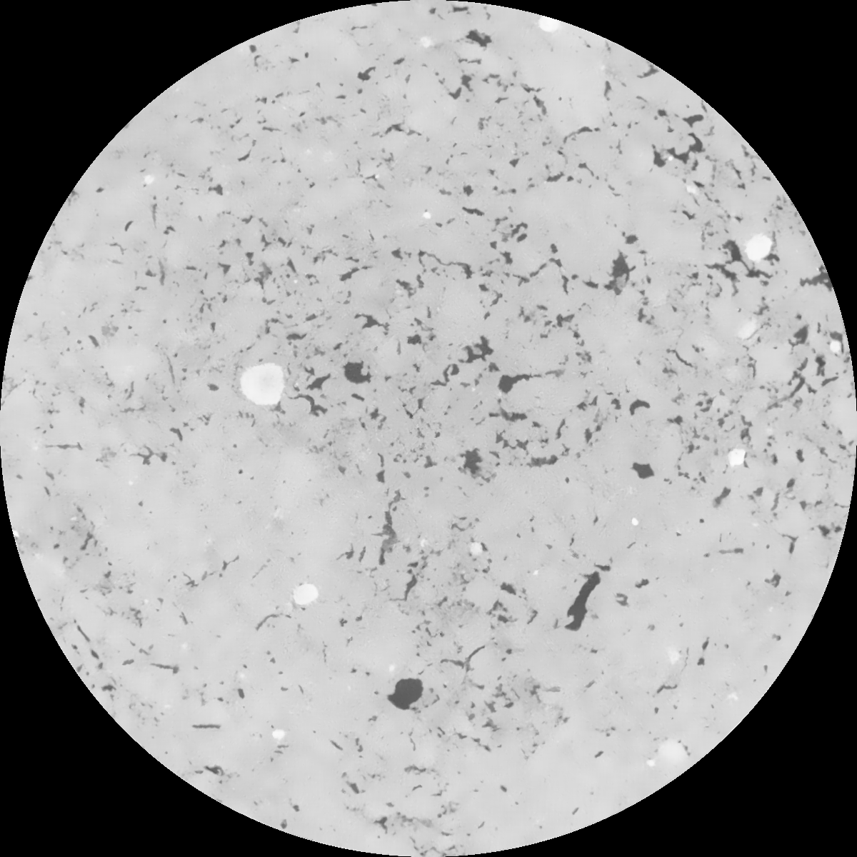
|
|---|
|
| Texture | clayey silt |
|---|
| Sand | 8.3 |
|---|
| Silt | 71.9 |
|---|
| Clay | 19.8 |
|---|
|
|
Results
| Porosity | Surface | Mean Curvature | Euler | MeanPoreSize | Gamma | PoreDist |
| 0.051138909 | 0.513624944 | 0.295731395 | 0.51337549 | 0.595275574767 | 0.522947303421 | 0.542704567 |
| Opening size | Volume | Surface | MeanCurvature | Euler number |
|---|
| 0.12 | 0.051138909 | 0.513624944 | 0.295731395 | 0.51337549 |
| 0.15 | 0.048722356 | 0.448024978 | 0.216753359 | 0.209025651 |
| 0.18 | 0.046846451 | 0.408548893 | 0.179049956 | 0.130376997 |
| 0.21 | 0.044897101 | 0.374750468 | 0.1549124 | 0.11454421 |
| 0.24 | 0.04388077 | 0.35972581 | 0.150268211 | 0.145600599 |
| 0.27 | 0.03720351 | 0.268292763 | 0.095756716 | 0.079800207 |
| 0.3 | 0.034157676 | 0.233010698 | 0.079557714 | 0.071110293 |
| 0.36 | 0.029936752 | 0.186543302 | 0.060412252 | 0.054983749 |
| 0.42 | 0.023204279 | 0.121925182 | 0.033241756 | 0.027333258 |
| 0.48 | 0.019818372 | 0.09383315 | 0.023187186 | 0.017539347 |
| 0.54 | 0.01588402 | 0.065112777 | 0.013643985 | 0.009593458 |
| 0.6 | 0.014256173 | 0.054498039 | 0.010662578 | 0.006602914 |
| 0.66 | 0.011837002 | 0.040511668 | 0.00695519 | 0.004201088 |
| 0.72 | 0.010753435 | 0.034508126 | 0.005523821 | 0.002643212 |
| 0.78 | 0.009412537 | 0.028227892 | 0.00422658 | 0.002102651 |
| 0.84 | 0.008809272 | 0.025379908 | 0.003683435 | 0.001551254 |
| 0.9 | 0.007748567 | 0.020964103 | 0.002851876 | 0.001233419 |
| 1.2 | 0.004990367 | 0.01106811 | 0.001258462 | 0.000443044 |
| 1.5 | 0.003221379 | 0.005955697 | 0.000586865 | 0.000226337 |
| 1.8 | 0.002206211 | 0.003398966 | 0.000276592 | 0.000077051 |
| 2.1 | 0.001581888 | 0.002101244 | 0.000151221 | 0.00005538 |
| 2.7 | 0.000938293 | 0.000942808 | 0.000046377 | 0.000009631 |
| 3.3 | 0.000766429 | 0.000766412 | 0.000040014 | 0.000009631 |
| 3.9 | 0.000535818 | 0.00047445 | 0.000019657 | 0.000002408 |
| 4.5 | 0.000312027 | 0.000321749 | 0.000016534 | 0.000002408 |
| 5.1 | 0.0 | 0.0 | 0.0 | 0.0 |
| 5.7 | 0.0 | 0.0 | 0.0 | 0.0 |
| 6.3 | 0.0 | 0.0 | 0.0 | 0.0 |
| 6.9 | 0.0 | 0.0 | 0.0 | 0.0 |
| 7.5 | 0.0 | 0.0 | 0.0 | 0.0 |
| 8.1 | 0.0 | 0.0 | 0.0 | 0.0 |
| 8.7 | 0.0 | 0.0 | 0.0 | 0.0 |
| 9.3 | 0.0 | 0.0 | 0.0 | 0.0 |
| 9.9 | 0.0 | 0.0 | 0.0 | 0.0 |
Reference: An open Soil Structure Library based on X-ray CT data
 Soil Structure Library