General Information
Internal Identifier Ad_4_B_2_o
| Soil Type | Haplic Luvisol |
|---|
| Classification | WRB |
|---|
|
| Location | Adenstedt |
|---|
| Latitude | 52.00772222 |
|---|
| Longitude | 9.939417 |
|---|
|
| Landuse | Cropland |
|---|
| Tillage | tillage |
|---|
| Crop | winter wheat, sugarbeets, winter wheat, silage mais |
|---|
|
| Sampling Depth | 15.0 |
|---|
| Sampling Date | March 24, 2021 |
|---|
| Voxel size | 0.06 |
|---|
| Pores white? | True |
|---|
|
| XY Plane |
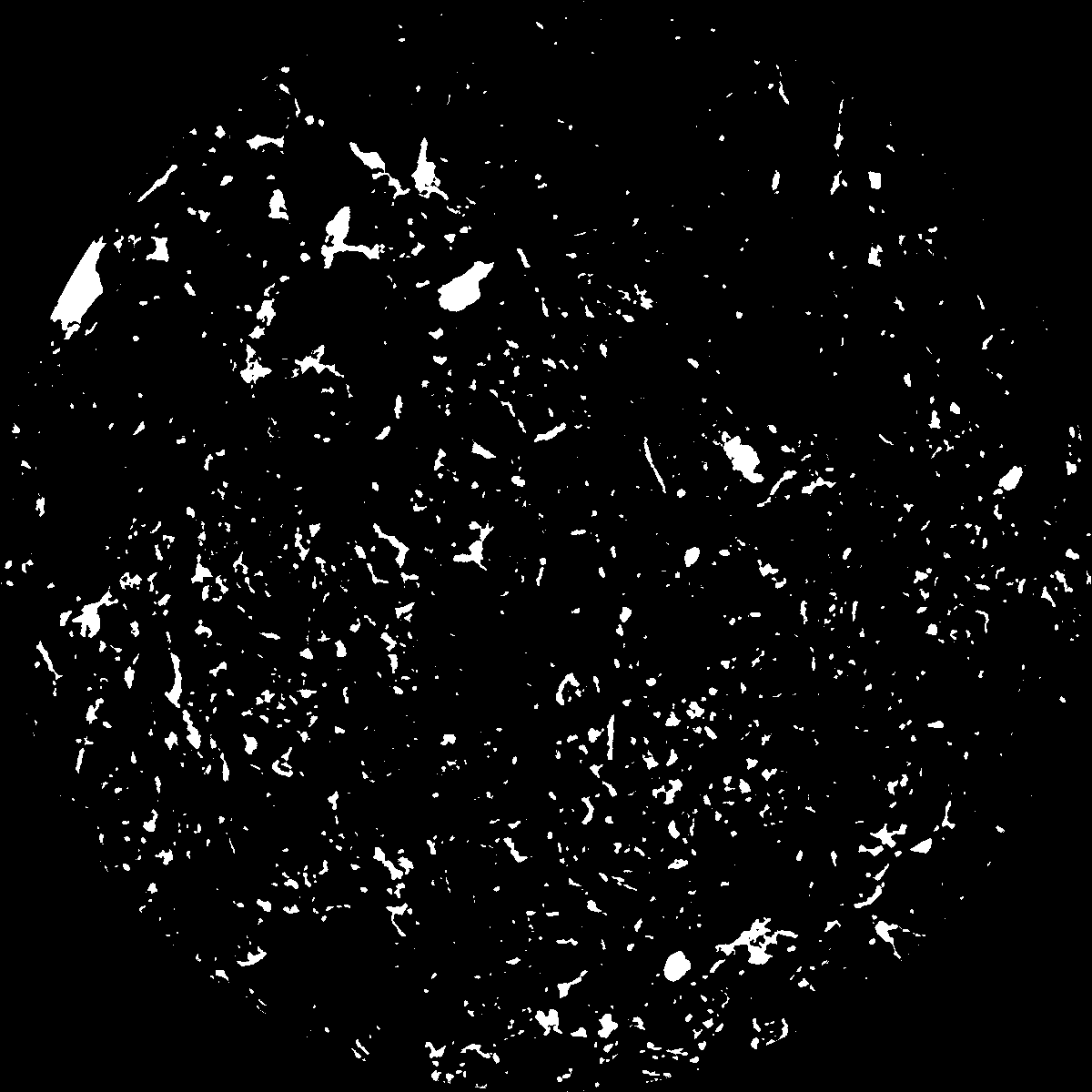
|
|---|
|
| XY Plane Grey |
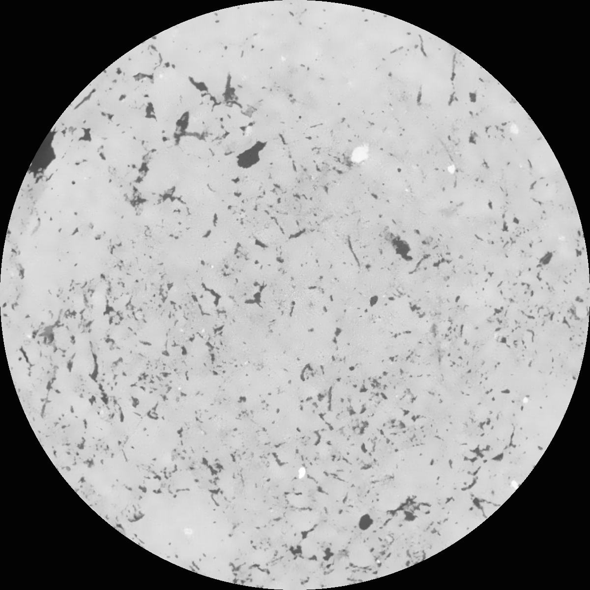
|
|---|
|
| Texture | clayey silt |
|---|
| Sand | 8.3 |
|---|
| Silt | 71.9 |
|---|
| Clay | 19.8 |
|---|
|
|
Results
| Porosity | Surface | Mean Curvature | Euler | MeanPoreSize | Gamma | PoreDist |
| 0.063297707 | 0.483574953 | 0.246575945 | 0.41386405 | 0.933071766016 | 0.631637167898 | 0.589985524 |
| Opening size | Volume | Surface | MeanCurvature | Euler number |
|---|
| 0.12 | 0.063297707 | 0.483574953 | 0.246575945 | 0.41386405 |
| 0.15 | 0.061212819 | 0.426190729 | 0.180010999 | 0.167532974 |
| 0.18 | 0.059594889 | 0.392660829 | 0.14916169 | 0.104890738 |
| 0.21 | 0.057950888 | 0.364561687 | 0.129695362 | 0.091847146 |
| 0.24 | 0.05708139 | 0.351784226 | 0.12586089 | 0.116533977 |
| 0.27 | 0.051468912 | 0.276669509 | 0.082906688 | 0.064962294 |
| 0.3 | 0.048863361 | 0.2471075 | 0.069916301 | 0.058777292 |
| 0.36 | 0.04518258 | 0.207302757 | 0.054243445 | 0.045815513 |
| 0.42 | 0.03901902 | 0.150218526 | 0.031719099 | 0.023253072 |
| 0.48 | 0.035695488 | 0.123732165 | 0.022923576 | 0.014925954 |
| 0.54 | 0.031617316 | 0.095718478 | 0.014528233 | 0.0084587 |
| 0.6 | 0.029803703 | 0.084503904 | 0.011672611 | 0.005591182 |
| 0.66 | 0.026917293 | 0.069401302 | 0.008303696 | 0.004163559 |
| 0.72 | 0.025509712 | 0.062300839 | 0.006939778 | 0.002590038 |
| 0.78 | 0.023681626 | 0.054649298 | 0.00566841 | 0.002170069 |
| 0.84 | 0.022797408 | 0.050823871 | 0.005059848 | 0.001414669 |
| 0.9 | 0.021152116 | 0.04480683 | 0.00417894 | 0.00115287 |
| 1.2 | 0.01621957 | 0.029440793 | 0.002374252 | 0.000606774 |
| 1.5 | 0.012533826 | 0.020439829 | 0.001517144 | 0.000374973 |
| 1.8 | 0.009641772 | 0.014356061 | 0.000968404 | 0.000175896 |
| 2.1 | 0.007059648 | 0.009810738 | 0.000657003 | 0.000166351 |
| 2.7 | 0.003934364 | 0.004634798 | 0.000261269 | 0.000049087 |
| 3.3 | 0.002135631 | 0.002297876 | 0.00011847 | 0.00001909 |
| 3.9 | 0.001215463 | 0.001287848 | 0.000068828 | 0.000013635 |
| 4.5 | 0.000366708 | 0.000435971 | 0.000027605 | 0.000005454 |
| 5.1 | 0.0 | 0.0 | 0.0 | 0.0 |
| 5.7 | 0.0 | 0.0 | 0.0 | 0.0 |
| 6.3 | 0.0 | 0.0 | 0.0 | 0.0 |
| 6.9 | 0.0 | 0.0 | 0.0 | 0.0 |
| 7.5 | 0.0 | 0.0 | 0.0 | 0.0 |
| 8.1 | 0.0 | 0.0 | 0.0 | 0.0 |
| 8.7 | 0.0 | 0.0 | 0.0 | 0.0 |
| 9.3 | 0.0 | 0.0 | 0.0 | 0.0 |
| 9.9 | 0.0 | 0.0 | 0.0 | 0.0 |
Reference: An open Soil Structure Library based on X-ray CT data
 Soil Structure Library