General Information
Internal Identifier Ad_4_B_2_u
| Soil Type | Haplic Luvisol |
|---|
| Classification | WRB |
|---|
|
| Location | Adenstedt |
|---|
| Latitude | 52.00772222 |
|---|
| Longitude | 9.939417 |
|---|
|
| Landuse | Cropland |
|---|
| Tillage | tillage |
|---|
| Crop | winter wheat, sugarbeets, winter wheat, silage mais |
|---|
|
| Sampling Depth | 25.0 |
|---|
| Sampling Date | March 24, 2021 |
|---|
| Voxel size | 0.06 |
|---|
| Pores white? | True |
|---|
|
| XY Plane |
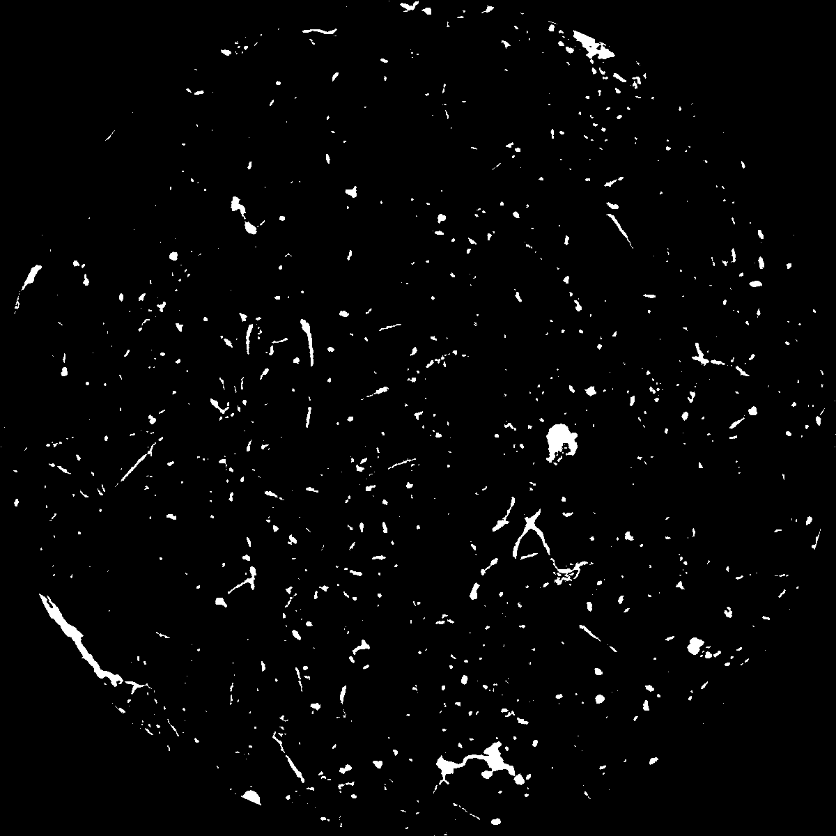
|
|---|
|
| XY Plane Grey |
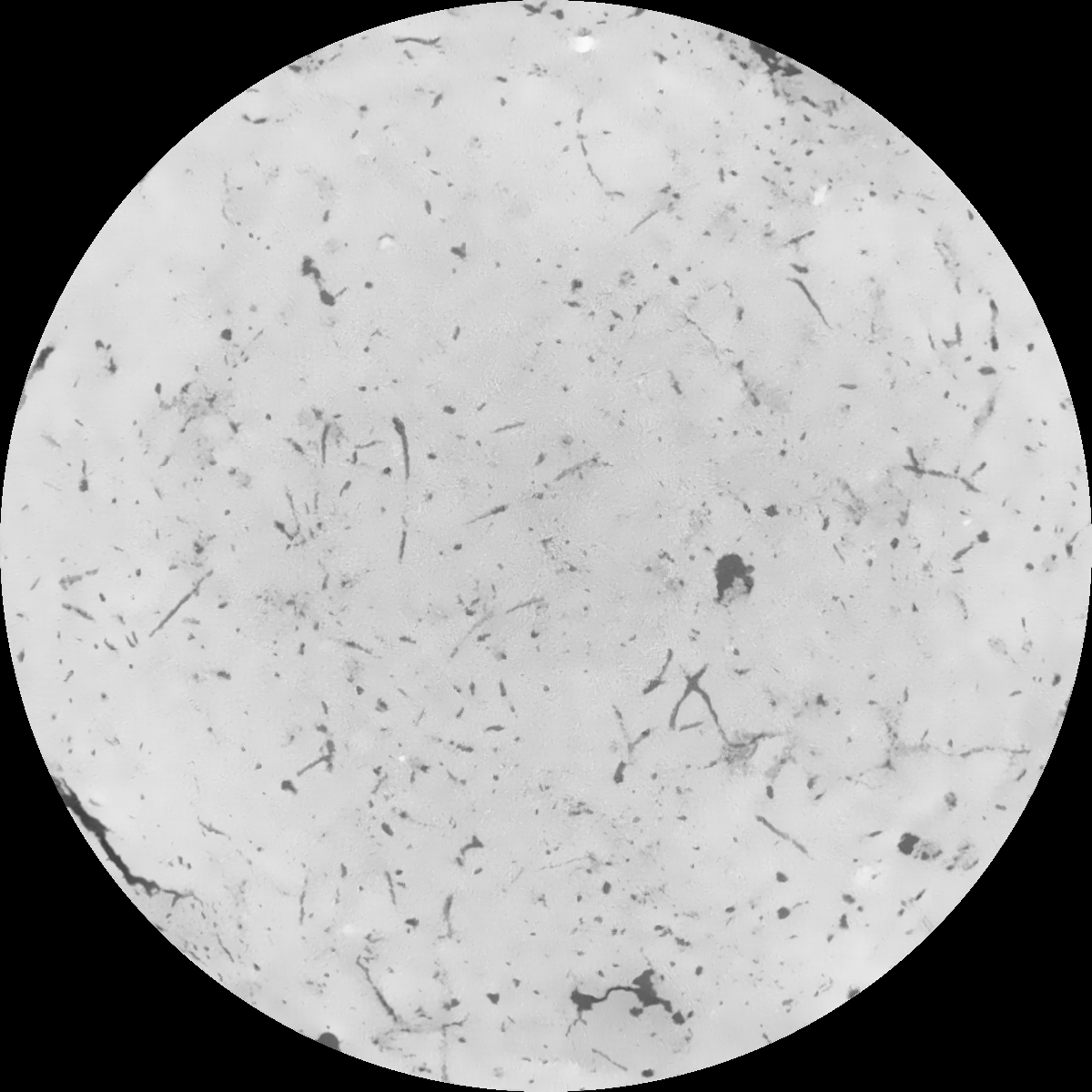
|
|---|
|
| Texture | clayey silt |
|---|
| Sand | 8.3 |
|---|
| Silt | 71.9 |
|---|
| Clay | 19.8 |
|---|
|
|
Results
| Porosity | Surface | Mean Curvature | Euler | MeanPoreSize | Gamma | PoreDist |
| 0.037027877 | 0.313279638 | 0.198154776 | 0.398690421 | 1.04175531691 | 0.550439695449 | 0.636879781 |
| Opening size | Volume | Surface | MeanCurvature | Euler number |
|---|
| 0.12 | 0.037027877 | 0.313279638 | 0.198154776 | 0.398690421 |
| 0.15 | 0.035235762 | 0.263970695 | 0.13547589 | 0.159786419 |
| 0.18 | 0.033843731 | 0.233836541 | 0.105439904 | 0.097986662 |
| 0.21 | 0.032548709 | 0.2105134 | 0.087287597 | 0.079535344 |
| 0.24 | 0.031944801 | 0.201347493 | 0.083874648 | 0.096841732 |
| 0.27 | 0.028144633 | 0.146497653 | 0.047742113 | 0.042519538 |
| 0.3 | 0.026676153 | 0.128709715 | 0.038636572 | 0.035150327 |
| 0.36 | 0.024685357 | 0.106275387 | 0.028656737 | 0.025789829 |
| 0.42 | 0.021565109 | 0.07603979 | 0.015552554 | 0.011323494 |
| 0.48 | 0.020013485 | 0.063435279 | 0.011173934 | 0.007033918 |
| 0.54 | 0.018120247 | 0.050337901 | 0.007167588 | 0.004063841 |
| 0.6 | 0.017283915 | 0.045202302 | 0.005879819 | 0.002727487 |
| 0.66 | 0.015914015 | 0.038139901 | 0.004345444 | 0.002183314 |
| 0.72 | 0.01524399 | 0.034812173 | 0.003724961 | 0.00140558 |
| 0.78 | 0.014306809 | 0.03093395 | 0.003095259 | 0.00117563 |
| 0.84 | 0.013860266 | 0.029000531 | 0.002798467 | 0.000792783 |
| 0.9 | 0.01304126 | 0.0260364 | 0.002370213 | 0.000679614 |
| 1.2 | 0.010493532 | 0.018185441 | 0.00144978 | 0.000402712 |
| 1.5 | 0.008309365 | 0.012829378 | 0.000942271 | 0.000272688 |
| 1.8 | 0.006532703 | 0.00894322 | 0.00057879 | 0.00011678 |
| 2.1 | 0.005092001 | 0.006330813 | 0.00038333 | 0.000103537 |
| 2.7 | 0.003489325 | 0.003809633 | 0.000209132 | 0.000056584 |
| 3.3 | 0.002392134 | 0.002379231 | 0.000121007 | 0.000026486 |
| 3.9 | 0.001607576 | 0.001475458 | 0.000068559 | 0.000012039 |
| 4.5 | 0.001151494 | 0.001049107 | 0.000049657 | 0.000007224 |
| 5.1 | 0.000809533 | 0.000733965 | 0.000034267 | 0.000004816 |
| 5.7 | 0.0 | 0.0 | 0.0 | 0.0 |
| 6.3 | 0.0 | 0.0 | 0.0 | 0.0 |
| 6.9 | 0.0 | 0.0 | 0.0 | 0.0 |
| 7.5 | 0.0 | 0.0 | 0.0 | 0.0 |
| 8.1 | 0.0 | 0.0 | 0.0 | 0.0 |
| 8.7 | 0.0 | 0.0 | 0.0 | 0.0 |
| 9.3 | 0.0 | 0.0 | 0.0 | 0.0 |
| 9.9 | 0.0 | 0.0 | 0.0 | 0.0 |
Reference: An open Soil Structure Library based on X-ray CT data
 Soil Structure Library