General Information
Internal Identifier leuther
| Soil Type | Fluvic Gleysol |
|---|
| Classification | FAO |
|---|
|
| Location | Giessen |
|---|
| Latitude | 50°32'00 |
|---|
| Longitude | 8°41'18.0 |
|---|
|
| Landuse | Grassland |
|---|
| Tillage | No tillage |
|---|
| Crop | gras |
|---|
|
| Sampling Depth | -4.0 |
|---|
| Sample Height | 5.0 |
|---|
| Sampling Date | March 1, 2020 |
|---|
| Voxel size | 0.048 |
|---|
| Pores white? | True |
|---|
|
| XY Plane |
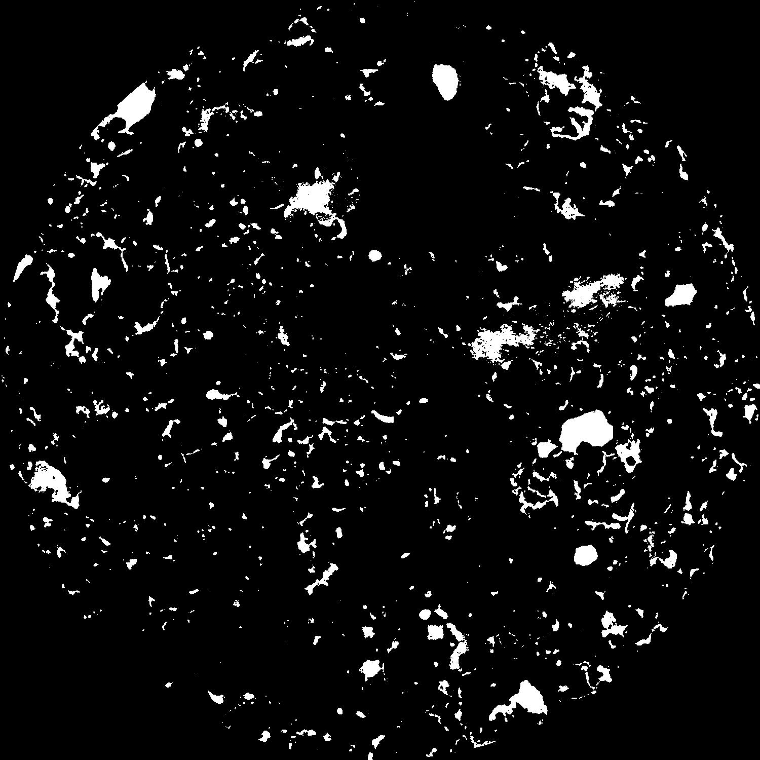
|
|---|
|
| XY Plane Grey |
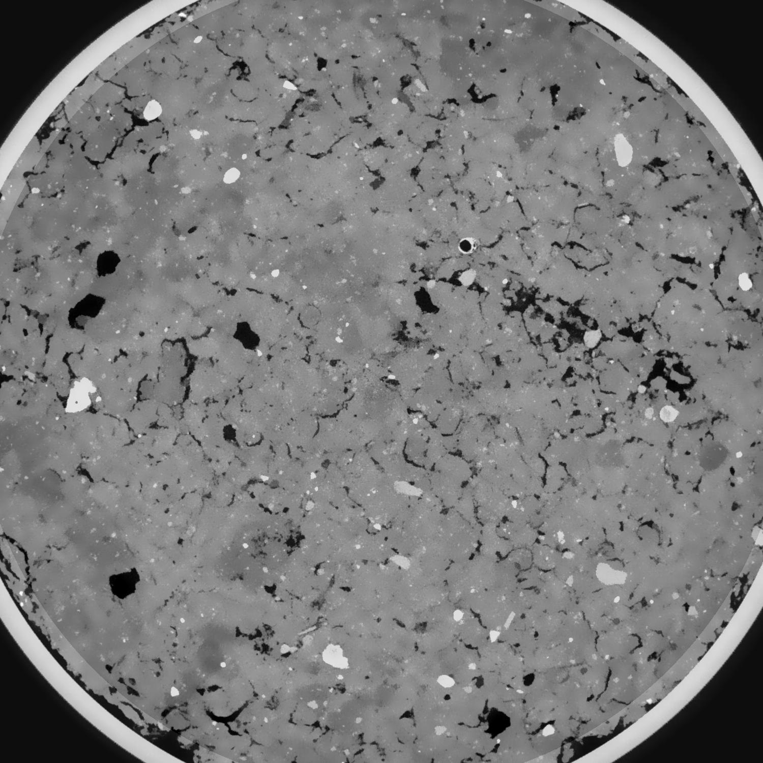
|
|---|
|
| Texture | silt clay |
|---|
| Sand | 20.0 |
|---|
| Silt | 40.0 |
|---|
| Clay | 40.0 |
|---|
|
|
Results
| Porosity | Surface | Mean Curvature | Euler | MeanPoreSize | Gamma | PoreDist |
| 0.083086426 | 0.731741435 | 0.334684526 | 0.453401867 | 0.750678484538 | 0.805185006924 | 0.515807335 |
| Opening size | Volume | Surface | MeanCurvature | Euler number |
|---|
| 0.096 | 0.083086426 | 0.731741435 | 0.334684526 | 0.453401867 |
| 0.12 | 0.081245798 | 0.653850202 | 0.249825063 | 0.039022531 |
| 0.144 | 0.079467177 | 0.613813521 | 0.216571496 | -0.002286915 |
| 0.168 | 0.077737935 | 0.581193297 | 0.196998713 | 0.027606433 |
| 0.192 | 0.076789415 | 0.564667289 | 0.193631054 | 0.086682465 |
| 0.216 | 0.070569245 | 0.475200658 | 0.150648873 | 0.066619014 |
| 0.24 | 0.067404706 | 0.435831539 | 0.135598132 | 0.074481795 |
| 0.288 | 0.063198139 | 0.383509758 | 0.116547893 | 0.076431855 |
| 0.336 | 0.054385987 | 0.291745622 | 0.082215338 | 0.058851463 |
| 0.384 | 0.048850705 | 0.240411055 | 0.064801383 | 0.048006738 |
| 0.432 | 0.041188484 | 0.175423975 | 0.042330027 | 0.037234501 |
| 0.48 | 0.037628846 | 0.146934976 | 0.032879918 | 0.026516275 |
| 0.528 | 0.032200162 | 0.107766101 | 0.020129959 | 0.017624454 |
| 0.576 | 0.029947965 | 0.09206411 | 0.015385663 | 0.010543403 |
| 0.624 | 0.027333095 | 0.076692544 | 0.011299651 | 0.007714963 |
| 0.672 | 0.026210836 | 0.070010451 | 0.009595501 | 0.005167945 |
| 0.72 | 0.024320709 | 0.06039588 | 0.007351326 | 0.003743775 |
| 0.96 | 0.019786006 | 0.04119981 | 0.003820872 | 0.001645897 |
| 1.2 | 0.016886576 | 0.031831316 | 0.002555185 | 0.00110295 |
| 1.44 | 0.014576479 | 0.025624362 | 0.001822102 | 0.000395129 |
| 1.68 | 0.012627386 | 0.021701607 | 0.001537041 | 0.000315535 |
| 2.16 | 0.006666005 | 0.011407489 | 0.000919712 | 0.000204671 |
| 2.64 | 0.002078978 | 0.003622131 | 0.000319214 | 0.000082437 |
| 3.12 | 0.000114169 | 0.000204126 | 0.00001924 | 0.000005685 |
Reference: An open Soil Structure Library based on X-ray CT data
 Soil Structure Library