General Information
Internal Identifier leuther
| Soil Type | Fluvic Gleysol |
|---|
| Classification | FAO |
|---|
|
| Location | Giessen |
|---|
| Latitude | 50°32'00 |
|---|
| Longitude | 8°41'18.0 |
|---|
|
| Landuse | Grassland |
|---|
| Tillage | No tillage |
|---|
| Crop | gras |
|---|
|
| Sampling Depth | -5.0 |
|---|
| Sample Height | 5.0 |
|---|
| Sampling Date | March 1, 2020 |
|---|
| Voxel size | 0.048 |
|---|
| Pores white? | True |
|---|
|
| XY Plane |
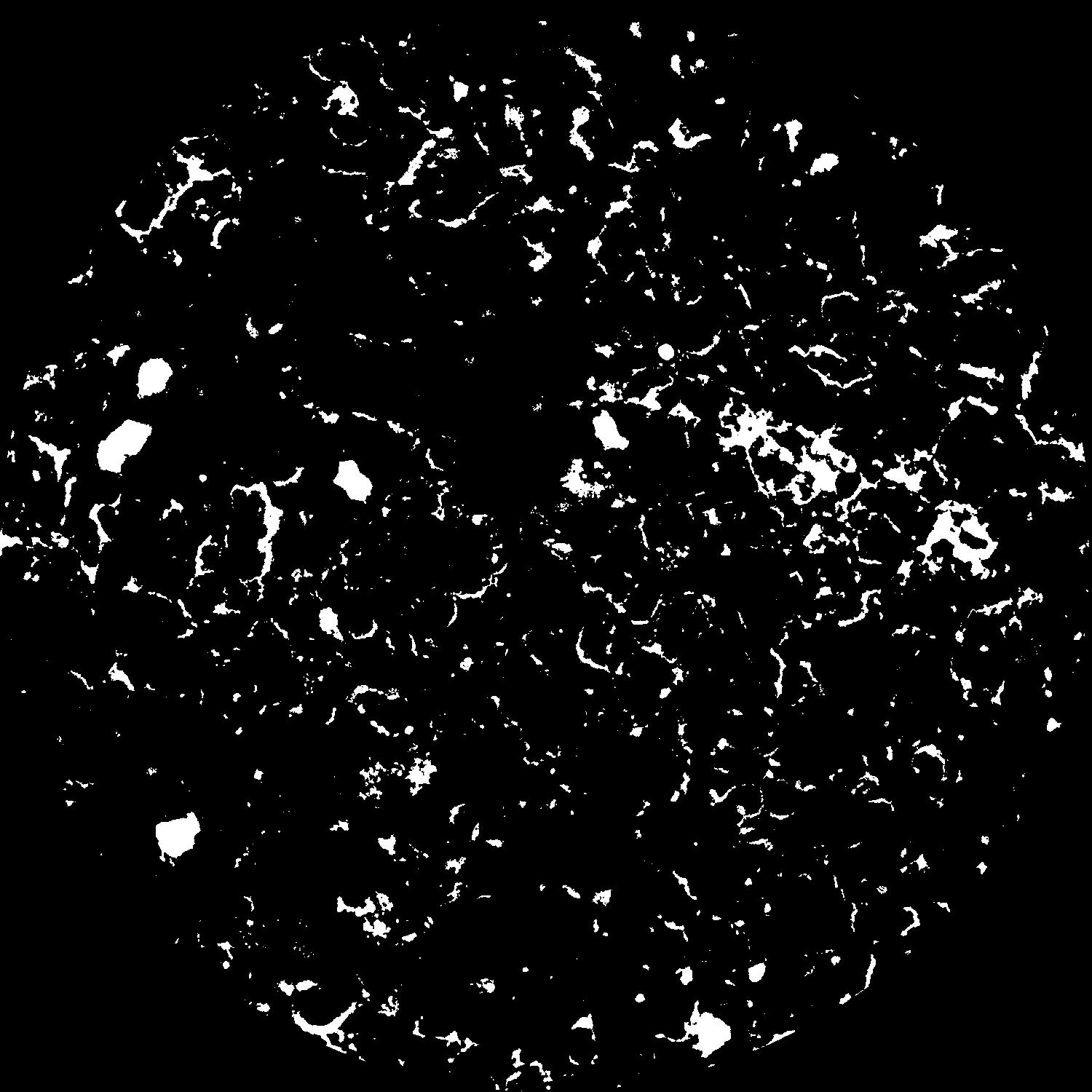
|
|---|
|
| XY Plane Grey |
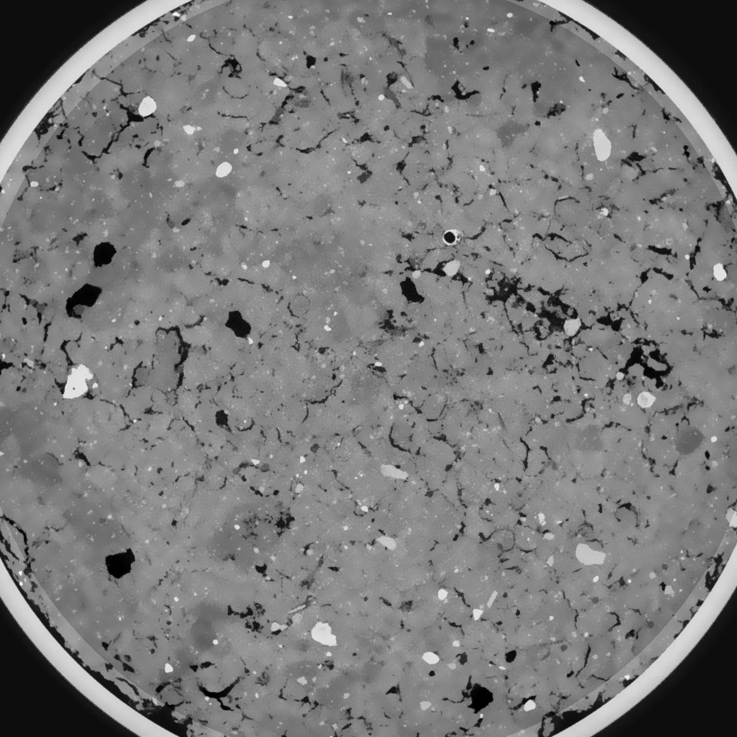
|
|---|
|
| Texture | silt clay |
|---|
| Sand | 20.0 |
|---|
| Silt | 40.0 |
|---|
| Clay | 40.0 |
|---|
|
|
Results
| Porosity | Surface | Mean Curvature | Euler | MeanPoreSize | Gamma | PoreDist |
| 0.081020558 | 0.742997321 | 0.339072905 | 0.476319342 | 0.666216901109 | 0.810242331207 | 0.481483419 |
| Opening size | Volume | Surface | MeanCurvature | Euler number |
|---|
| 0.096 | 0.081020558 | 0.742997321 | 0.339072905 | 0.476319342 |
| 0.12 | 0.079083109 | 0.662750547 | 0.250053183 | 0.063716665 |
| 0.144 | 0.077086567 | 0.618366287 | 0.214896982 | 0.016747495 |
| 0.168 | 0.075118845 | 0.581697202 | 0.193670287 | 0.039952078 |
| 0.192 | 0.074052791 | 0.5634265 | 0.190359145 | 0.099221411 |
| 0.216 | 0.067111186 | 0.464942389 | 0.14476619 | 0.06989233 |
| 0.24 | 0.0636788 | 0.422459462 | 0.128823138 | 0.075486673 |
| 0.288 | 0.059271992 | 0.368137501 | 0.109313924 | 0.073991437 |
| 0.336 | 0.050345004 | 0.275634884 | 0.074908566 | 0.053609609 |
| 0.384 | 0.045042079 | 0.226655013 | 0.058205447 | 0.041693204 |
| 0.432 | 0.038012197 | 0.168059002 | 0.038414748 | 0.031124217 |
| 0.48 | 0.034822017 | 0.143175426 | 0.030469351 | 0.021479092 |
| 0.528 | 0.029861457 | 0.109050161 | 0.020279443 | 0.015128604 |
| 0.576 | 0.027682809 | 0.094445921 | 0.016245576 | 0.009784415 |
| 0.624 | 0.024972179 | 0.079164175 | 0.012591243 | 0.008067452 |
| 0.672 | 0.023745269 | 0.072099319 | 0.010943075 | 0.005662566 |
| 0.72 | 0.021531954 | 0.060990464 | 0.008506241 | 0.004553931 |
| 0.96 | 0.016071961 | 0.037255982 | 0.003949772 | 0.001796557 |
| 1.2 | 0.01271751 | 0.026087728 | 0.002334686 | 0.000933812 |
| 1.44 | 0.010478329 | 0.020321341 | 0.001725312 | 0.000484672 |
| 1.68 | 0.008125794 | 0.015179907 | 0.001287901 | 0.000365281 |
| 2.16 | 0.003076177 | 0.005237593 | 0.000466761 | 0.000126498 |
| 2.64 | 0.001114515 | 0.001386418 | 0.00009524 | 0.000024163 |
| 3.12 | 0.000688686 | 0.000679445 | 0.000028975 | 0.000004264 |
| 3.6 | 0.000510819 | 0.000506207 | 0.000019738 | 0.0 |
| 4.08 | 0.000350022 | 0.000389128 | 0.000019991 | 0.0 |
Reference: An open Soil Structure Library based on X-ray CT data
 Soil Structure Library