General Information
Internal Identifier leuther
| Soil Type | Fluvic Gleysol |
|---|
| Classification | FAO |
|---|
|
| Location | Giessen |
|---|
| Latitude | 50°32'00 |
|---|
| Longitude | 8°41'18.0 |
|---|
|
| Landuse | Grassland |
|---|
| Tillage | No tillage |
|---|
| Crop | gras |
|---|
|
| Sampling Depth | -5.0 |
|---|
| Sample Height | 5.0 |
|---|
| Sampling Date | March 1, 2020 |
|---|
| Voxel size | 0.048 |
|---|
| Pores white? | True |
|---|
|
| XY Plane |
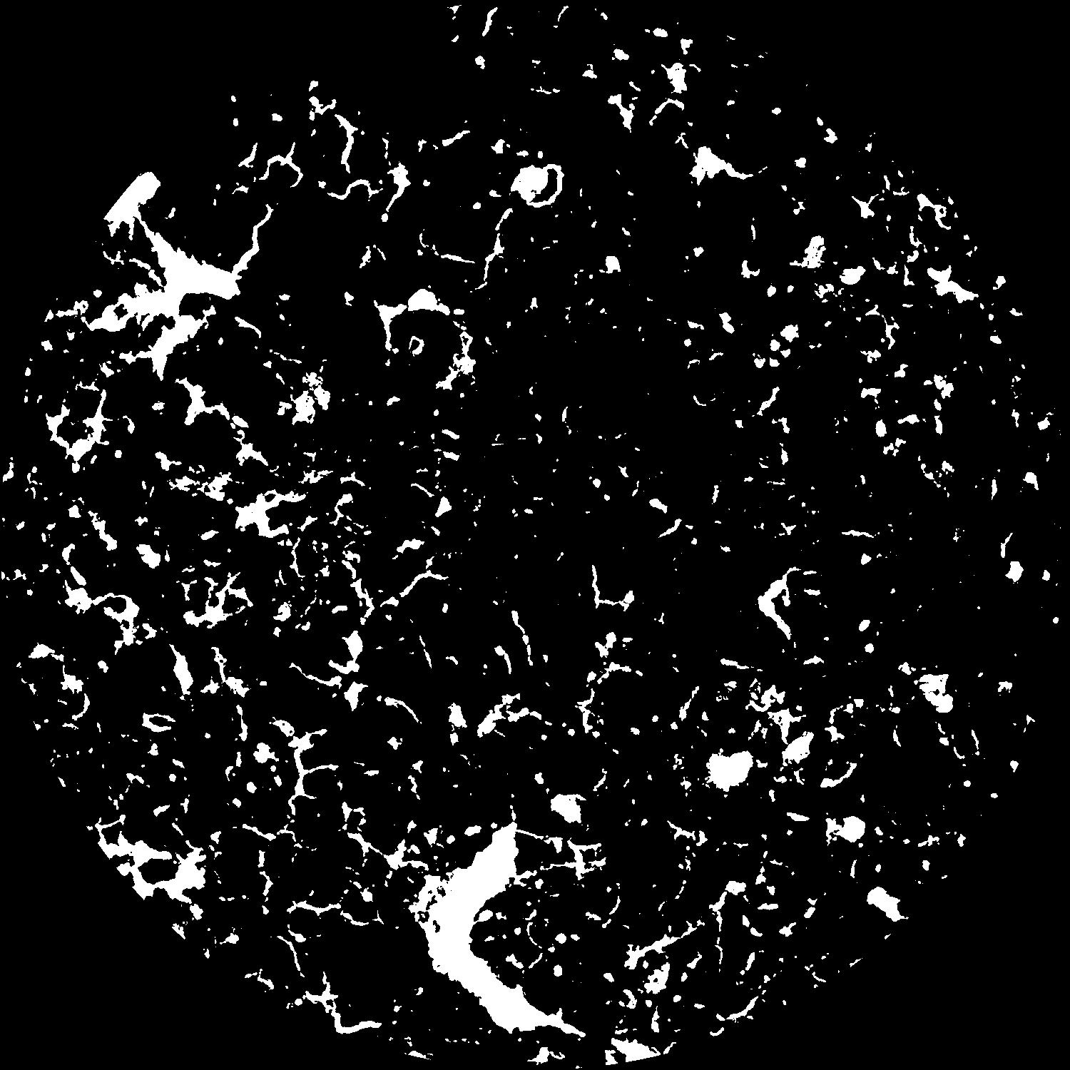
|
|---|
|
| XY Plane Grey |
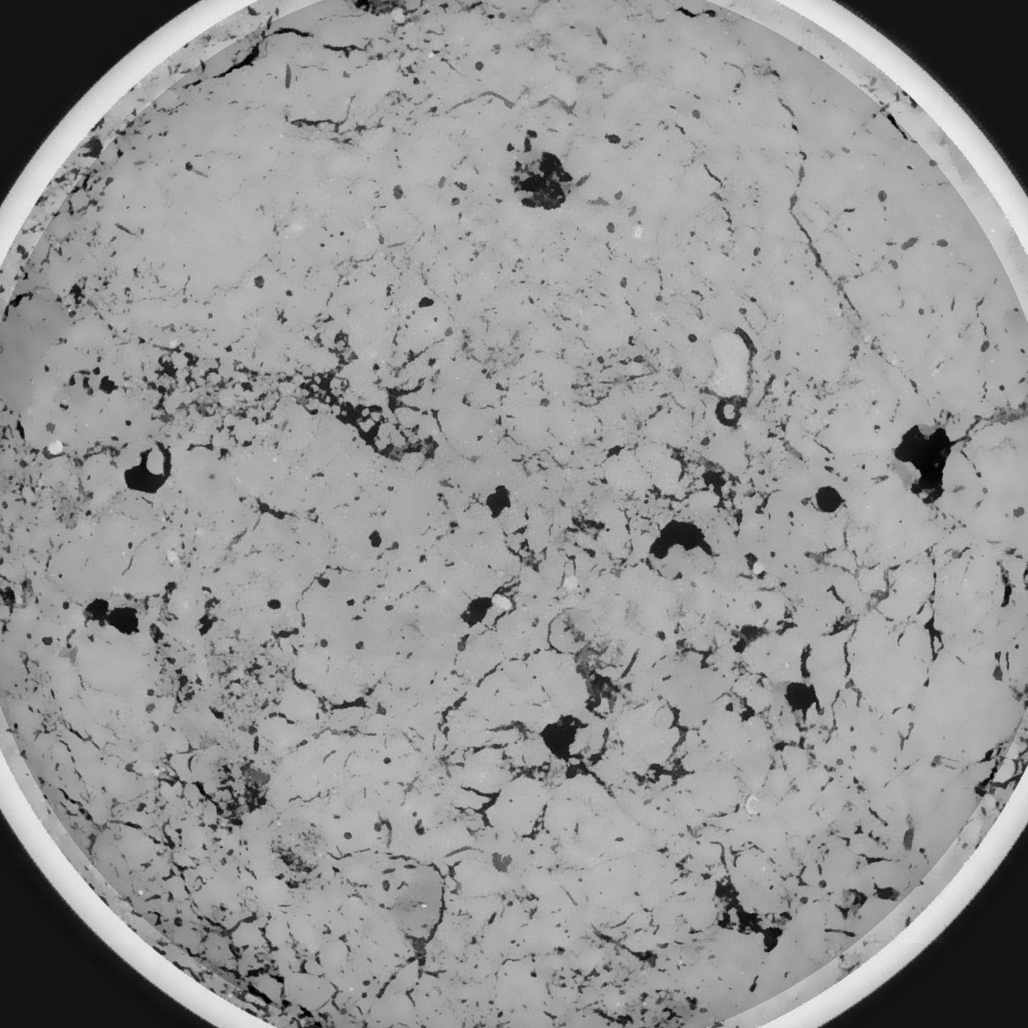
|
|---|
|
| Texture | silt clay |
|---|
| Sand | 20.0 |
|---|
| Silt | 40.0 |
|---|
| Clay | 40.0 |
|---|
|
|
Results
| Porosity | Surface | Mean Curvature | Euler | MeanPoreSize | Gamma | PoreDist |
| 0.098503227 | 0.880249658 | 0.393028343 | 0.47946616 | 0.756236530849 | 0.85147348875 | 0.416099153 |
| Opening size | Volume | Surface | MeanCurvature | Euler number |
|---|
| 0.096 | 0.098503227 | 0.880249658 | 0.393028343 | 0.47946616 |
| 0.12 | 0.096155511 | 0.784227803 | 0.288769663 | 0.054212251 |
| 0.144 | 0.093599848 | 0.72672522 | 0.243013604 | -0.011666251 |
| 0.168 | 0.091119443 | 0.680527842 | 0.216859157 | 0.020826703 |
| 0.192 | 0.089791052 | 0.657898344 | 0.213349845 | 0.100341417 |
| 0.216 | 0.08136339 | 0.538484687 | 0.15932869 | 0.06136579 |
| 0.24 | 0.077300889 | 0.488644183 | 0.14137479 | 0.071135991 |
| 0.288 | 0.072099444 | 0.425454786 | 0.120131946 | 0.076451754 |
| 0.336 | 0.061564624 | 0.318144832 | 0.082280108 | 0.056081296 |
| 0.384 | 0.055313798 | 0.261756118 | 0.064308263 | 0.044090982 |
| 0.432 | 0.046857099 | 0.192639616 | 0.042025585 | 0.033338644 |
| 0.48 | 0.042930337 | 0.162934861 | 0.033297313 | 0.023963572 |
| 0.528 | 0.036666919 | 0.120706465 | 0.021331625 | 0.017615926 |
| 0.576 | 0.033922945 | 0.102407085 | 0.016306362 | 0.011009598 |
| 0.624 | 0.030700419 | 0.084328056 | 0.011954793 | 0.008095878 |
| 0.672 | 0.029311034 | 0.076622528 | 0.010261269 | 0.005725105 |
| 0.72 | 0.026795396 | 0.064249039 | 0.00758665 | 0.004158803 |
| 0.96 | 0.020938104 | 0.04031738 | 0.003420556 | 0.001463967 |
| 1.2 | 0.017258287 | 0.029691892 | 0.002280895 | 0.000733405 |
| 1.44 | 0.014343403 | 0.022597108 | 0.001616303 | 0.00046051 |
| 1.68 | 0.0117413 | 0.016803692 | 0.001082896 | 0.000304164 |
| 2.16 | 0.008537692 | 0.011260512 | 0.000702848 | 0.000153503 |
| 2.64 | 0.005648293 | 0.006779423 | 0.000388003 | 0.000082437 |
| 3.12 | 0.003773052 | 0.004454746 | 0.000252005 | 0.00004264 |
| 3.6 | 0.001806494 | 0.002041092 | 0.000114027 | 0.000017056 |
| 4.08 | 0.001113976 | 0.001345555 | 0.000085659 | 0.000017056 |
| 4.56 | 0.000161031 | 0.000201497 | 0.000013541 | 0.000002843 |
Reference: An open Soil Structure Library based on X-ray CT data
 Soil Structure Library