General Information
Internal Identifier leuther
| Soil Type | Fluvic Gleysol |
|---|
| Classification | FAO |
|---|
|
| Location | Giessen |
|---|
| Latitude | 50°32'00 |
|---|
| Longitude | 8°41'18.0 |
|---|
|
| Landuse | Grassland |
|---|
| Tillage | No tillage |
|---|
| Crop | gras |
|---|
|
| Sampling Depth | -5.0 |
|---|
| Sample Height | 5.0 |
|---|
| Sampling Date | March 1, 2020 |
|---|
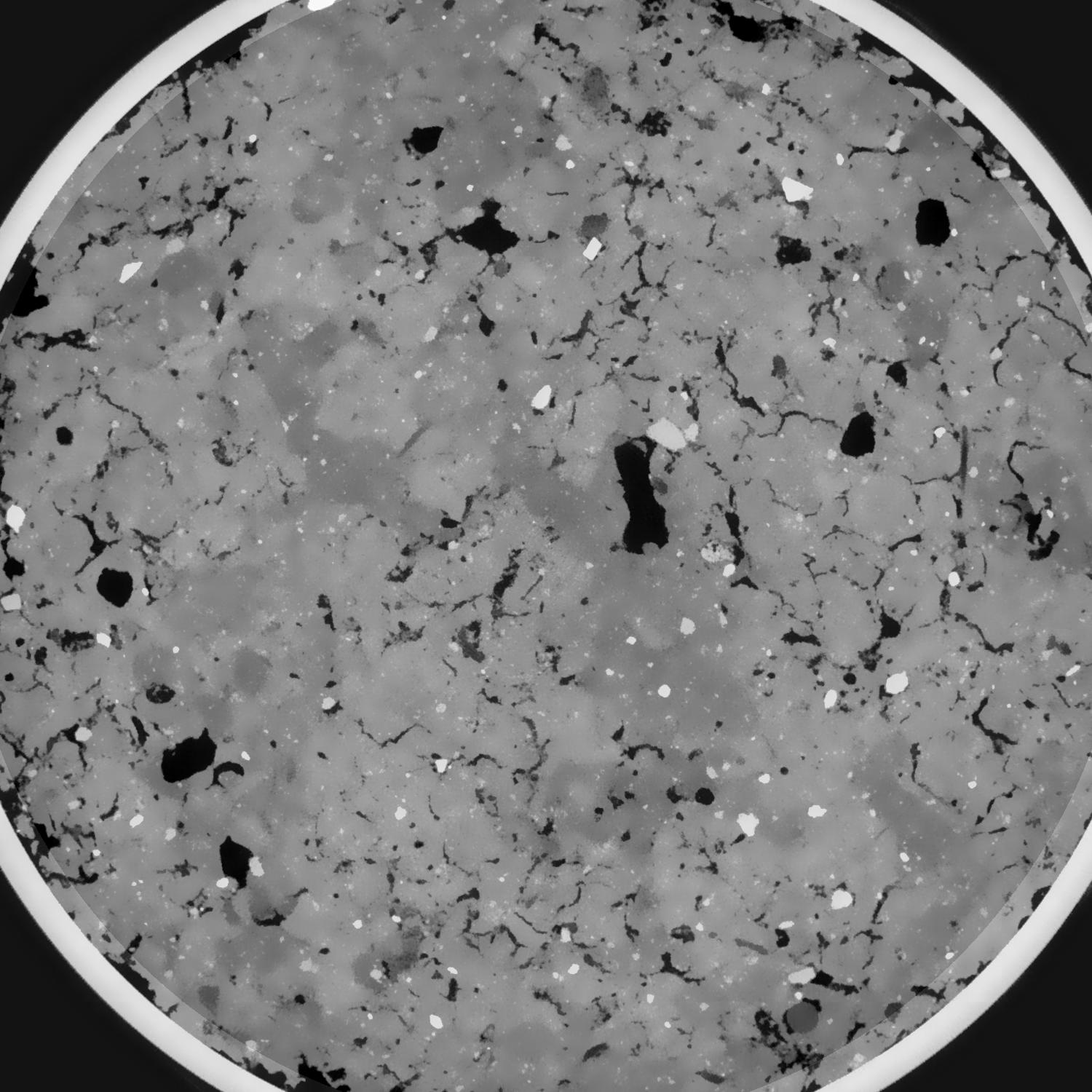
| Voxel size | 0.048 |
|---|
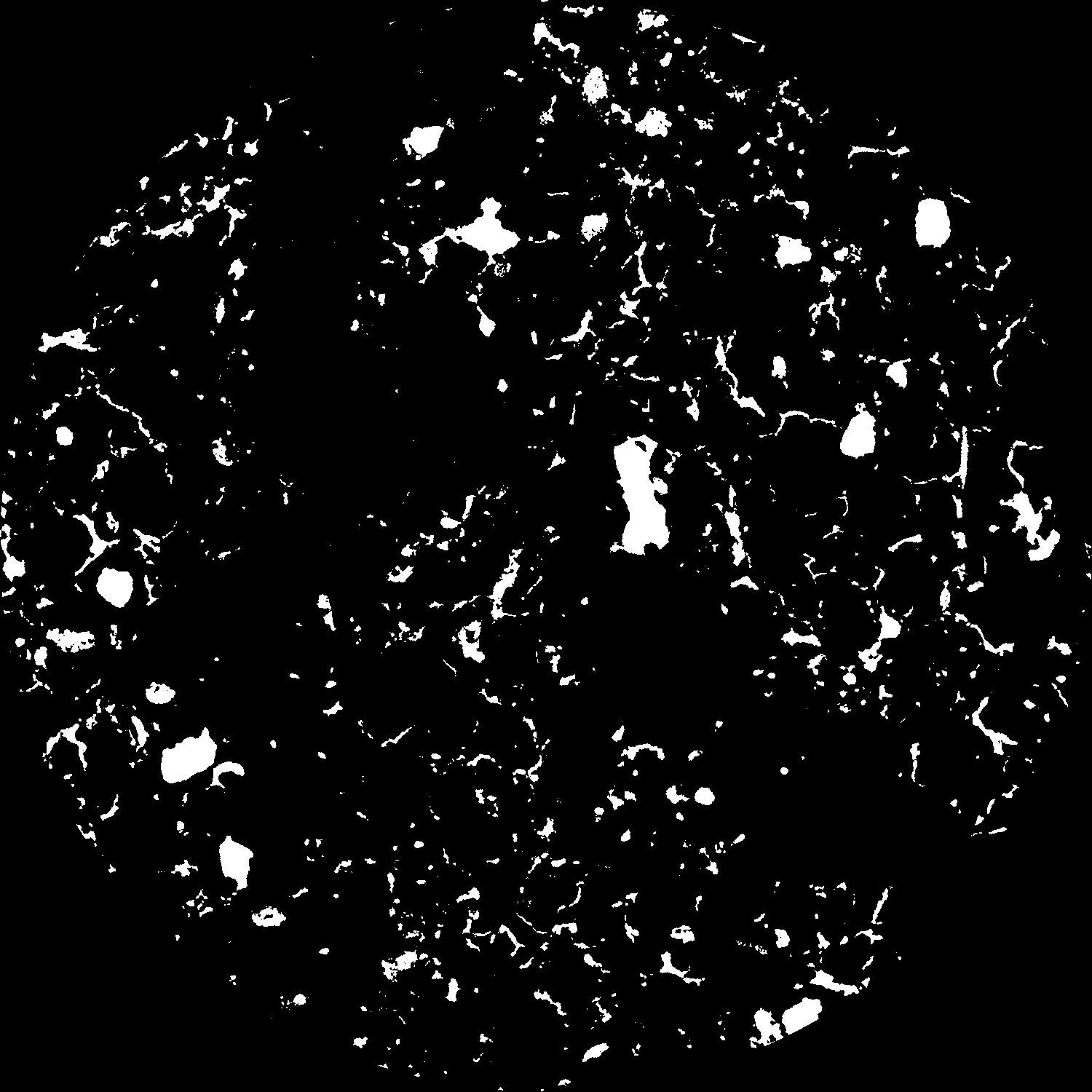
| Pores white? | True |
|---|
|
| XY Plane |
|
|---|
|
| XY Plane Grey |
|
|---|
|
| Texture | silt clay |
|---|
| Sand | 20.0 |
|---|
| Silt | 40.0 |
|---|
| Clay | 40.0 |
|---|
|
|
Results
| Porosity | Surface | Mean Curvature | Euler | MeanPoreSize | Gamma | PoreDist |
| 0.100998262 | 0.748579482 | 0.282991938 | 0.262917054 | 0.850068082926 | 0.87072397748 | 0.542781666 |
| Opening size | Volume | Surface | MeanCurvature | Euler number |
|---|
| 0.096 | 0.100998262 | 0.748579482 | 0.282991938 | 0.262917054 |
| 0.12 | 0.099399576 | 0.681388935 | 0.215626664 | -0.004227026 |
| 0.144 | 0.097744522 | 0.644833646 | 0.188163574 | -0.032386355 |
| 0.168 | 0.096089697 | 0.614368743 | 0.171728882 | -0.005125305 |
| 0.192 | 0.095156434 | 0.598402946 | 0.169243853 | 0.052478233 |
| 0.216 | 0.089025631 | 0.512812722 | 0.132284189 | 0.035955307 |
| 0.24 | 0.085897655 | 0.474902292 | 0.119270198 | 0.045513731 |
| 0.288 | 0.081640226 | 0.423646697 | 0.102992951 | 0.05269001 |
| 0.336 | 0.072809071 | 0.335305537 | 0.073745101 | 0.041916352 |
| 0.384 | 0.067313315 | 0.286546184 | 0.058928385 | 0.032524224 |
| 0.432 | 0.059651458 | 0.226412641 | 0.041518453 | 0.027751408 |
| 0.48 | 0.056037063 | 0.199686611 | 0.034094592 | 0.019338574 |
| 0.528 | 0.049967899 | 0.160759975 | 0.024169133 | 0.016006984 |
| 0.576 | 0.047109914 | 0.142502745 | 0.019640961 | 0.009340961 |
| 0.624 | 0.043451594 | 0.123144566 | 0.015605665 | 0.007564302 |
| 0.672 | 0.041777009 | 0.11411052 | 0.013816253 | 0.00471312 |
| 0.72 | 0.038618595 | 0.099390352 | 0.011066605 | 0.003844689 |
| 0.96 | 0.029856594 | 0.065217652 | 0.00607005 | 0.001878994 |
| 1.2 | 0.023804893 | 0.046666367 | 0.003911065 | 0.001174016 |
| 1.44 | 0.019380925 | 0.035493822 | 0.002830995 | 0.000693608 |
| 1.68 | 0.015542925 | 0.027319185 | 0.00217904 | 0.000577059 |
| 2.16 | 0.007464816 | 0.011630836 | 0.000901253 | 0.000221727 |
| 2.64 | 0.002686465 | 0.003007359 | 0.000162514 | 0.000025584 |
| 3.12 | 0.001776715 | 0.001720633 | 0.000076943 | 0.000008528 |
| 3.6 | 0.001378271 | 0.001333906 | 0.00006095 | 0.000005685 |
| 4.08 | 0.000879042 | 0.000834614 | 0.000039847 | 0.000005685 |
| 4.56 | 0.000557984 | 0.000525286 | 0.000023715 | 0.000002843 |
Reference: An open Soil Structure Library based on X-ray CT data
 Soil Structure Library