General Information
Internal Identifier leuther
| Soil Type | Haplic Chernozem |
|---|
| Classification | FAO |
|---|
|
| Location | Bad Lauchstädt |
|---|
| Latitude | 51.39178 |
|---|
| Longitude | 11.87701 |
|---|
|
| Landuse | Grassland |
|---|
| Tillage | No tillage |
|---|
| Crop | gras |
|---|
|
| Sampling Depth | 5.0 |
|---|
| Sample Height | 5.0 |
|---|
| Sampling Date | March 1, 2020 |
|---|
| Voxel size | 0.048 |
|---|
| Pores white? | True |
|---|
|
| XY Plane |
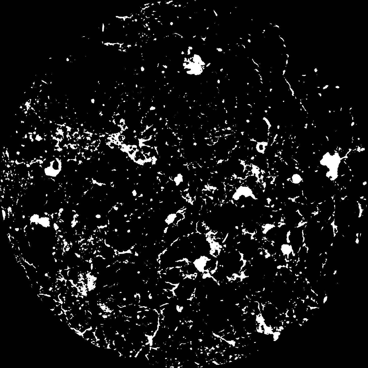
|
|---|
|
| XY Plane Grey |
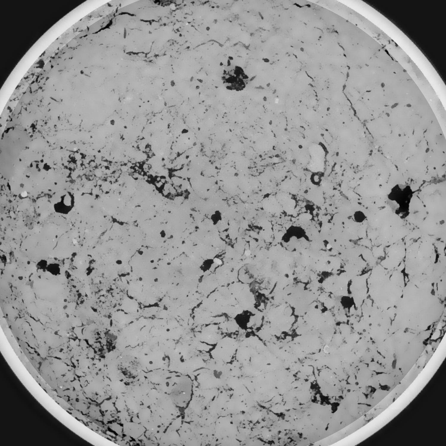
|
|---|
|
| Texture | silty loam |
|---|
| Sand | 11.0 |
|---|
| Silt | 68.0 |
|---|
| Clay | 21.0 |
|---|
|
|
Results
| Porosity | Surface | Mean Curvature | Euler | MeanPoreSize | Gamma | PoreDist |
| 0.091791523 | 0.955243967 | 0.551961989 | 1.214533804 | 0.623035220202 | 0.775198985389 | 0.352168528 |
| Opening size | Volume | Surface | MeanCurvature | Euler number |
|---|
| 0.096 | 0.091791523 | 0.955243967 | 0.551961989 | 1.214533804 |
| 0.12 | 0.088303798 | 0.81573746 | 0.365946779 | 0.206419309 |
| 0.144 | 0.085009932 | 0.736497882 | 0.288437337 | 0.043174227 |
| 0.168 | 0.082111041 | 0.678915076 | 0.247931509 | 0.054783625 |
| 0.192 | 0.080622268 | 0.652612 | 0.241849351 | 0.148443384 |
| 0.216 | 0.071560838 | 0.515133165 | 0.165031751 | 0.068146941 |
| 0.24 | 0.067305452 | 0.460504932 | 0.142301995 | 0.073795294 |
| 0.288 | 0.062008124 | 0.393948473 | 0.117624791 | 0.075486673 |
| 0.336 | 0.051579192 | 0.28409504 | 0.076039888 | 0.052103002 |
| 0.384 | 0.045729686 | 0.230139674 | 0.058012318 | 0.040055835 |
| 0.432 | 0.038264707 | 0.167992063 | 0.037272754 | 0.027626331 |
| 0.48 | 0.034929042 | 0.142539815 | 0.029654356 | 0.019973907 |
| 0.528 | 0.029613021 | 0.106517609 | 0.019528527 | 0.015084543 |
| 0.576 | 0.027281117 | 0.090892897 | 0.01519851 | 0.009257102 |
| 0.624 | 0.02443708 | 0.074531153 | 0.011096908 | 0.006610592 |
| 0.672 | 0.023239069 | 0.067727676 | 0.009546296 | 0.004532612 |
| 0.72 | 0.021111406 | 0.057108715 | 0.007215067 | 0.003279001 |
| 0.96 | 0.016106279 | 0.036311219 | 0.00361478 | 0.001397164 |
| 1.2 | 0.012918984 | 0.026245563 | 0.002309018 | 0.000757567 |
| 1.44 | 0.010367979 | 0.019880618 | 0.001727774 | 0.000461931 |
| 1.68 | 0.007695357 | 0.013630757 | 0.001119834 | 0.000361017 |
| 2.16 | 0.004578436 | 0.00741201 | 0.000582656 | 0.000144975 |
| 2.64 | 0.002808726 | 0.004628438 | 0.000391806 | 0.000099493 |
| 3.12 | 0.000835599 | 0.001401974 | 0.000124081 | 0.000034112 |
Reference: An open Soil Structure Library based on X-ray CT data
 Soil Structure Library