General Information
Internal Identifier leuther
| Soil Type | Haplic Chernozem |
|---|
| Classification | FAO |
|---|
|
| Location | Bad Lauchstädt |
|---|
| Latitude | 51.39178 |
|---|
| Longitude | 11.87701 |
|---|
|
| Landuse | Grassland |
|---|
| Tillage | No tillage |
|---|
| Crop | gras |
|---|
|
| Sampling Depth | 5.0 |
|---|
| Sample Height | 5.0 |
|---|
| Sampling Date | March 1, 2020 |
|---|
| Voxel size | 0.048 |
|---|
| Pores white? | True |
|---|
|
| XY Plane |
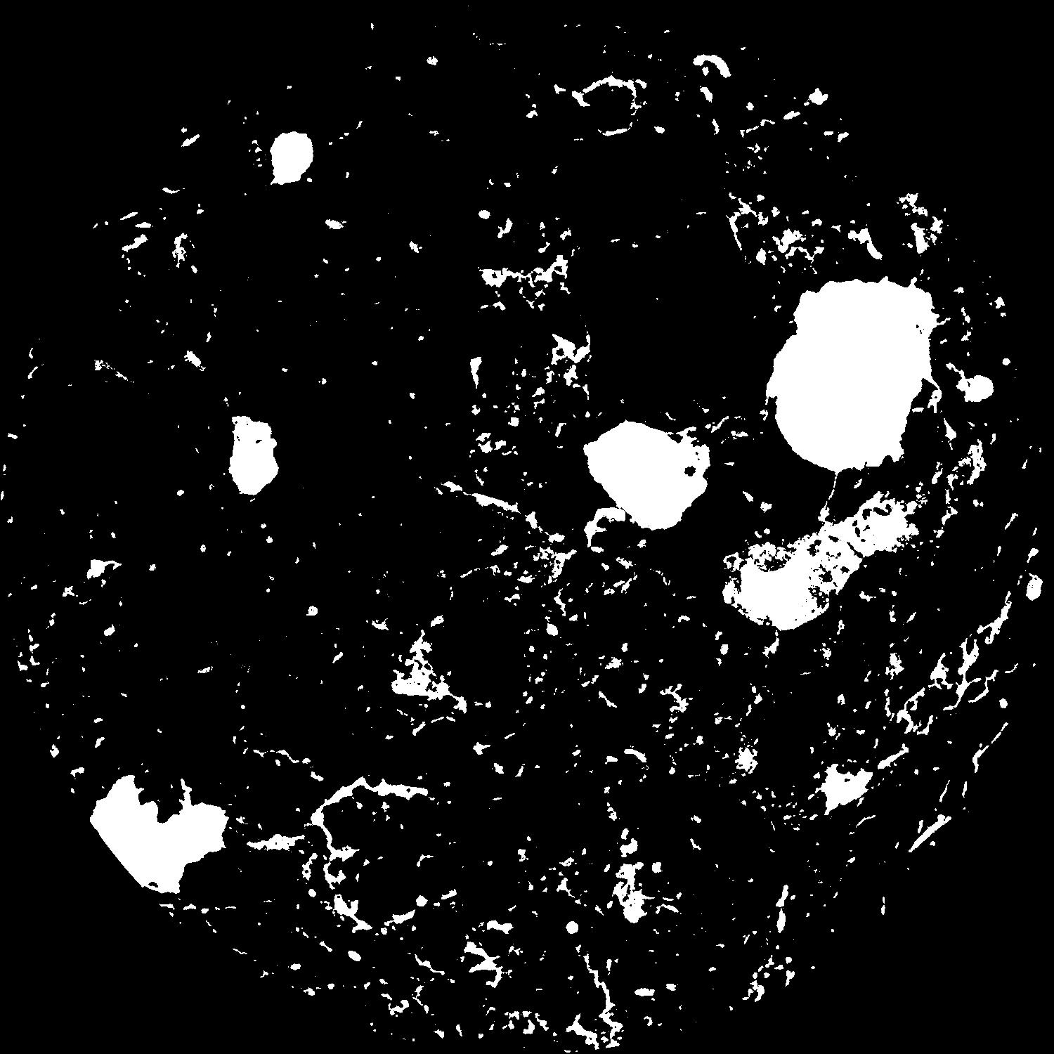
|
|---|
|
| XY Plane Grey |
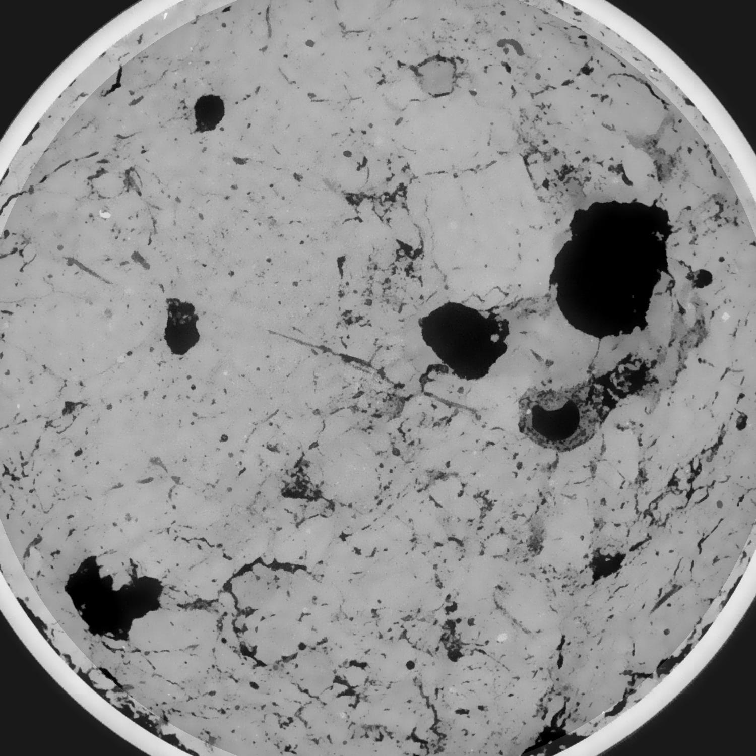
|
|---|
|
| Texture | silty loam |
|---|
| Sand | 11.0 |
|---|
| Silt | 68.0 |
|---|
| Clay | 21.0 |
|---|
|
|
Results
| Porosity | Surface | Mean Curvature | Euler | MeanPoreSize | Gamma | PoreDist |
| 0.106504762 | 0.618447211 | 0.321285486 | 0.678446094 | 2.82297186993 | 0.840429521387 | 0.516386743 |
| Opening size | Volume | Surface | MeanCurvature | Euler number |
|---|
| 0.096 | 0.106504762 | 0.618447211 | 0.321285486 | 0.678446094 |
| 0.12 | 0.104598788 | 0.539615157 | 0.224653459 | 0.15473262 |
| 0.144 | 0.102777666 | 0.496507253 | 0.183295348 | 0.069113115 |
| 0.168 | 0.101081615 | 0.463076223 | 0.159746162 | 0.072603892 |
| 0.192 | 0.1001931 | 0.447285264 | 0.155637254 | 0.12556397 |
| 0.216 | 0.094549578 | 0.361213569 | 0.105546463 | 0.067242343 |
| 0.24 | 0.091787651 | 0.325545664 | 0.089870354 | 0.063931092 |
| 0.288 | 0.088332629 | 0.281899222 | 0.072927967 | 0.059035455 |
| 0.336 | 0.081534331 | 0.209996225 | 0.044496186 | 0.036552 |
| 0.384 | 0.07772709 | 0.17496244 | 0.032486495 | 0.025677872 |
| 0.432 | 0.072974757 | 0.135920604 | 0.019502052 | 0.016002008 |
| 0.48 | 0.07091179 | 0.120541447 | 0.01505041 | 0.010852755 |
| 0.528 | 0.067655599 | 0.099549204 | 0.009482047 | 0.007701082 |
| 0.576 | 0.066222324 | 0.090579886 | 0.007333257 | 0.0046178 |
| 0.624 | 0.064466885 | 0.081657494 | 0.005580838 | 0.003785712 |
| 0.672 | 0.063618132 | 0.077108664 | 0.00469499 | 0.002281116 |
| 0.72 | 0.062154533 | 0.070662746 | 0.003614201 | 0.002044598 |
| 0.96 | 0.05832646 | 0.057290818 | 0.00198564 | 0.001127022 |
| 1.2 | 0.055334235 | 0.050202052 | 0.001674207 | 0.000807866 |
| 1.44 | 0.052728852 | 0.045179229 | 0.001497966 | 0.000349078 |
| 1.68 | 0.050315788 | 0.041307236 | 0.001419039 | 0.000514355 |
| 2.16 | 0.045355733 | 0.033929955 | 0.001133822 | 0.000294935 |
| 2.64 | 0.04087128 | 0.028195792 | 0.00089252 | 0.000284961 |
| 3.12 | 0.036625078 | 0.023361282 | 0.000675895 | 0.000159578 |
| 3.6 | 0.032451205 | 0.019409095 | 0.000533315 | 0.000128233 |
| 4.08 | 0.029364031 | 0.016688028 | 0.000431354 | 0.000082639 |
| 4.56 | 0.027373078 | 0.015290821 | 0.0004027 | 0.000079789 |
| 5.04 | 0.024516615 | 0.013242656 | 0.000342028 | 0.000079789 |
| 5.52 | 0.020976237 | 0.010911865 | 0.000291985 | 0.000039895 |
| 6.0 | 0.017993247 | 0.008446153 | 0.000180378 | 0.000019947 |
| 6.48 | 0.016584824 | 0.007674737 | 0.000164017 | 0.000014248 |
| 6.96 | 0.015969419 | 0.007400348 | 0.00016011 | 0.000014248 |
| 7.44 | 0.015145659 | 0.007060917 | 0.000155103 | 0.000014248 |
| 7.92 | 0.012999941 | 0.006140337 | 0.000140131 | 0.000008549 |
| 8.4 | 0.010204444 | 0.004686126 | 0.000103013 | 0.000005699 |
| 8.88 | 0.009172508 | 0.004297824 | 0.000097451 | 0.000005699 |
| 9.36 | 0.005697871 | 0.002875141 | 0.000074342 | 0.000005699 |
| 9.84 | 0.00452109 | 0.002416735 | 0.000066946 | 0.000005699 |
Reference: An open Soil Structure Library based on X-ray CT data
 Soil Structure Library