General Information
Internal Identifier leuther
| Soil Type | Haplic Chernozem |
|---|
| Classification | FAO |
|---|
|
| Location | Bad Lauchstädt |
|---|
| Latitude | 51.39178 |
|---|
| Longitude | 11.87701 |
|---|
|
| Landuse | Grassland |
|---|
| Tillage | No tillage |
|---|
| Crop | gras |
|---|
|
| Sampling Depth | 5.0 |
|---|
| Sample Height | 5.0 |
|---|
| Sampling Date | March 1, 2020 |
|---|
| Voxel size | 0.048 |
|---|
| Pores white? | True |
|---|
|
| XY Plane |
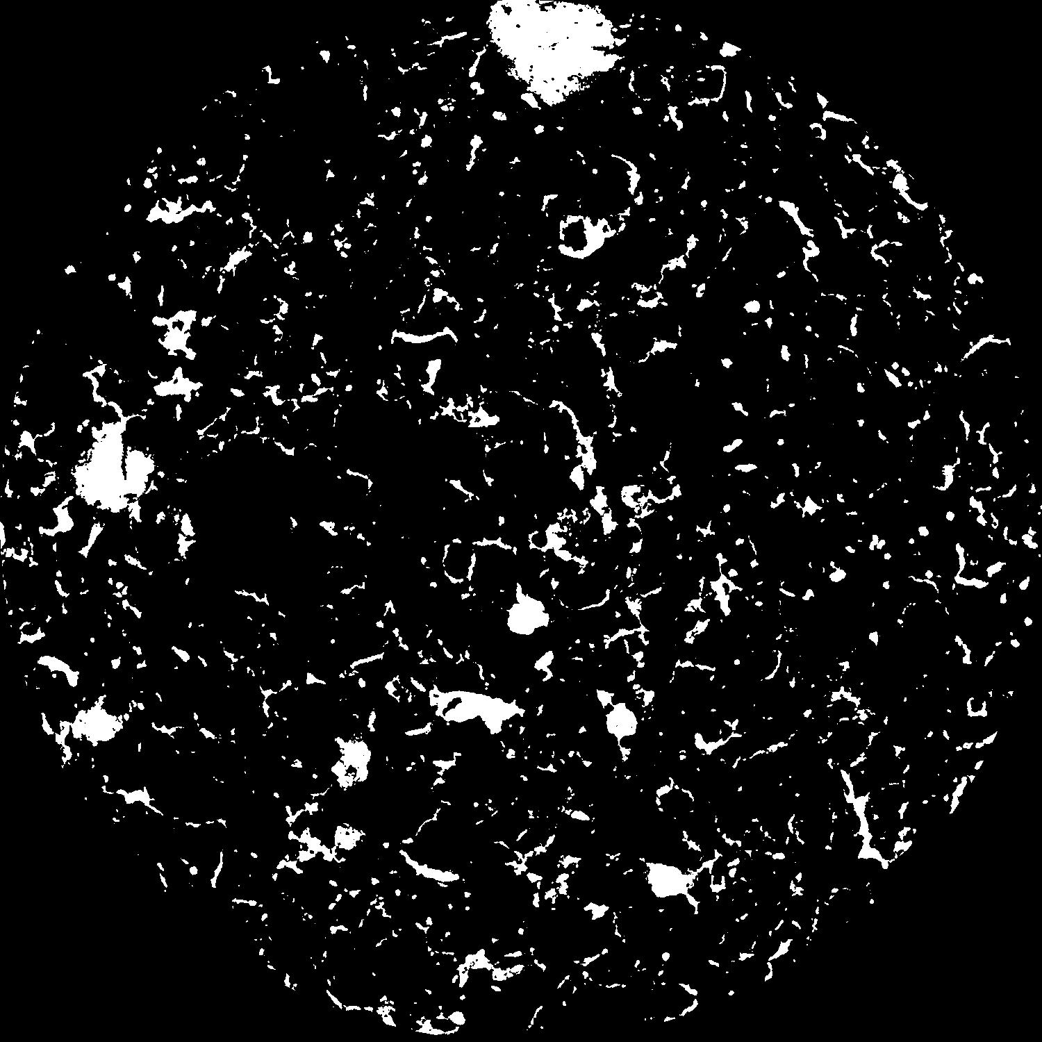
|
|---|
|
| XY Plane Grey |
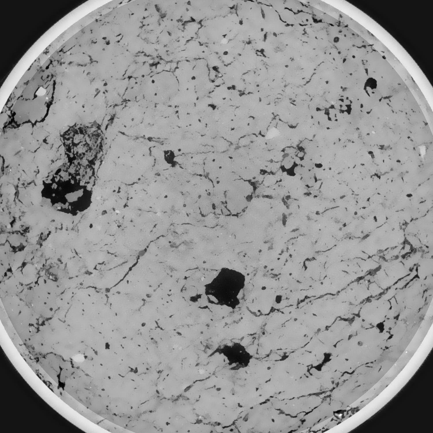
|
|---|
|
| Texture | silty loam |
|---|
| Sand | 11.0 |
|---|
| Silt | 68.0 |
|---|
| Clay | 21.0 |
|---|
|
|
Results
| Porosity | Surface | Mean Curvature | Euler | MeanPoreSize | Gamma | PoreDist |
| 0.098290216 | 0.839526528 | 0.427562519 | 0.797716691 | 1.14721375223 | 0.819901469327 | 0.384501361 |
| Opening size | Volume | Surface | MeanCurvature | Euler number |
|---|
| 0.096 | 0.098290216 | 0.839526528 | 0.427562519 | 0.797716691 |
| 0.12 | 0.095015672 | 0.71222322 | 0.279754717 | 0.136775777 |
| 0.144 | 0.091473349 | 0.633353572 | 0.22112945 | 0.034711149 |
| 0.168 | 0.088595675 | 0.579212142 | 0.189367062 | 0.057827219 |
| 0.192 | 0.087162189 | 0.554974805 | 0.185103119 | 0.134339357 |
| 0.216 | 0.078377384 | 0.425332504 | 0.118086357 | 0.053668207 |
| 0.24 | 0.074752632 | 0.379902826 | 0.099971741 | 0.053266411 |
| 0.288 | 0.07036615 | 0.326198277 | 0.080880149 | 0.055055969 |
| 0.336 | 0.061695626 | 0.237542345 | 0.049026295 | 0.031392774 |
| 0.384 | 0.05700308 | 0.195988926 | 0.036287173 | 0.021786724 |
| 0.432 | 0.051001943 | 0.148707651 | 0.022357082 | 0.01472823 |
| 0.48 | 0.048382402 | 0.129858291 | 0.017407883 | 0.009316813 |
| 0.528 | 0.044108965 | 0.10355621 | 0.011332879 | 0.006177963 |
| 0.576 | 0.042169857 | 0.091955052 | 0.008956359 | 0.003564867 |
| 0.624 | 0.039721539 | 0.079641042 | 0.006739526 | 0.002578901 |
| 0.672 | 0.038654326 | 0.074282732 | 0.005886206 | 0.001527393 |
| 0.72 | 0.036664072 | 0.065837269 | 0.00471452 | 0.001487499 |
| 0.96 | 0.031304331 | 0.047019298 | 0.00269918 | 0.000854884 |
| 1.2 | 0.027364512 | 0.036622957 | 0.00194186 | 0.000612667 |
| 1.44 | 0.024427512 | 0.03022322 | 0.001519224 | 0.000421743 |
| 1.68 | 0.021483035 | 0.024808556 | 0.001260187 | 0.000464487 |
| 2.16 | 0.017010703 | 0.017122925 | 0.000758264 | 0.00014533 |
| 2.64 | 0.014104945 | 0.013004486 | 0.00052098 | 0.000082639 |
| 3.12 | 0.011958933 | 0.010522142 | 0.000383822 | 0.000054143 |
| 3.6 | 0.009251589 | 0.007856051 | 0.000296709 | 0.00007124 |
| 4.08 | 0.007088933 | 0.006071546 | 0.000246112 | 0.000022797 |
| 4.56 | 0.004690762 | 0.003883784 | 0.000166971 | 0.000022797 |
| 5.04 | 0.00320194 | 0.002484546 | 0.000097722 | 0.000011398 |
| 5.52 | 0.002590171 | 0.002099218 | 0.000088127 | 0.000011398 |
| 6.0 | 0.001312683 | 0.001052264 | 0.000043943 | 0.000005699 |
| 6.48 | 0.001035646 | 0.000888005 | 0.00004019 | 0.000005699 |
Reference: An open Soil Structure Library based on X-ray CT data
 Soil Structure Library