General Information
Internal Identifier leuther
| Soil Type | Haplic Chernozem |
|---|
| Classification | FAO |
|---|
|
| Location | Bad Lauchstädt |
|---|
| Latitude | 51.39178 |
|---|
| Longitude | 11.87701 |
|---|
|
| Landuse | Grassland |
|---|
| Tillage | No tillage |
|---|
| Crop | gras |
|---|
|
| Sampling Depth | 5.0 |
|---|
| Sample Height | 3.0 |
|---|
| Sampling Date | June 1, 2021 |
|---|
| Voxel size | 0.015 |
|---|
| Pores white? | True |
|---|
|
| XY Plane |
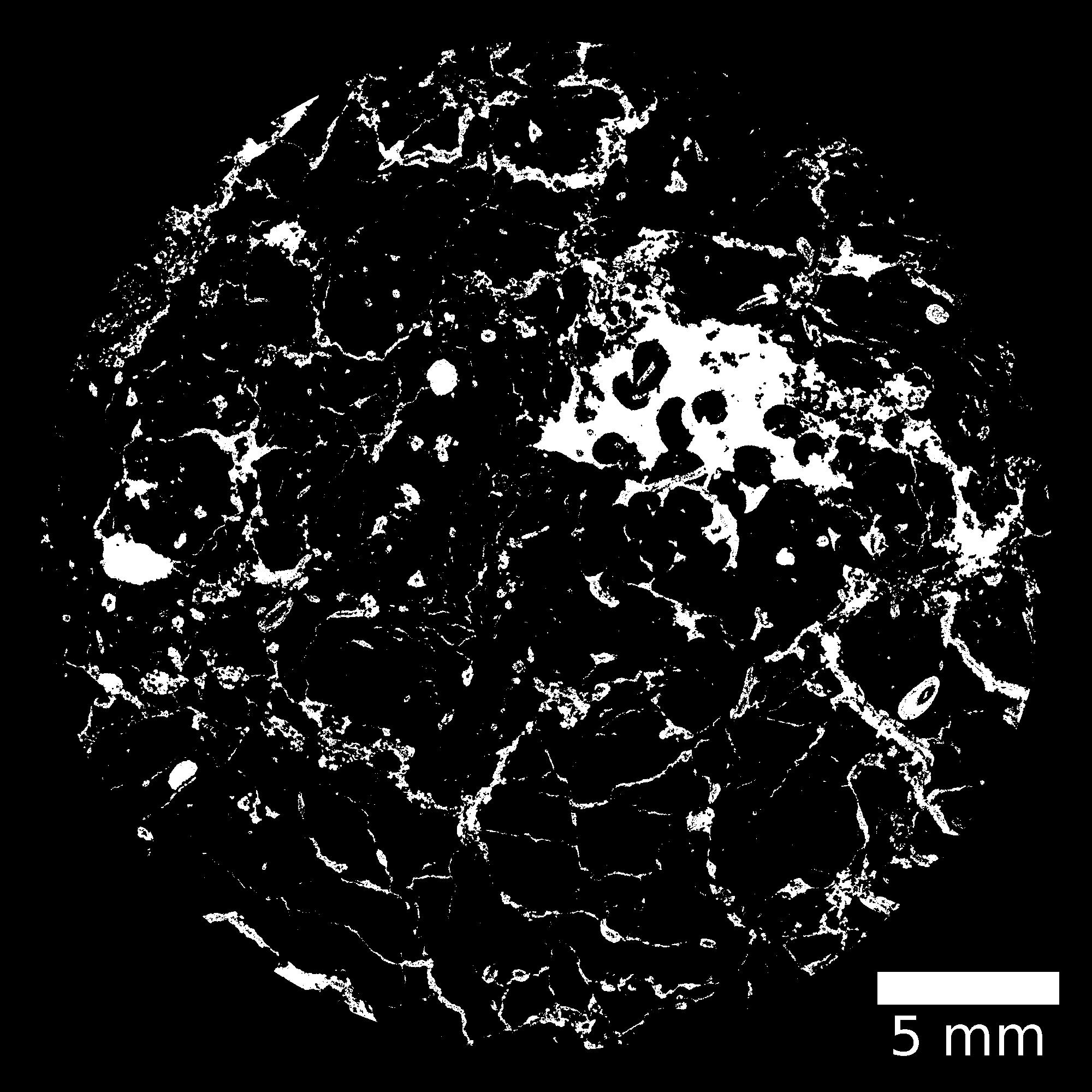
|
|---|
|
| XY Plane Grey |
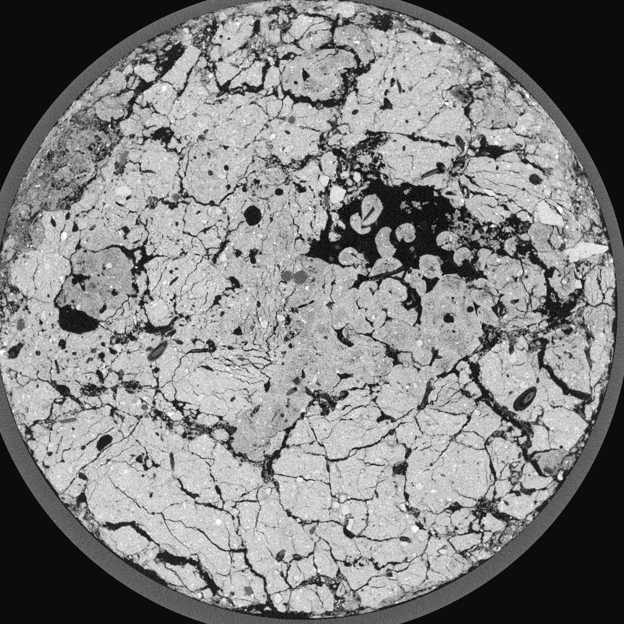
|
|---|
|
| Texture | silty loam |
|---|
| Sand | 11.0 |
|---|
| Silt | 68.0 |
|---|
| Clay | 21.0 |
|---|
|
|
Results
| Porosity | Surface | Mean Curvature | Euler | MeanPoreSize | Gamma | PoreDist |
| 0.321389136 | 12.80972304 | 15.336868887 | -2.512263225 | 0.137567245923 | 0.848212436959 | 0.128469565 |
| Opening size | Volume | Surface | MeanCurvature | Euler number |
|---|
| 0.03 | 0.321389136 | 12.80972304 | 15.336868887 | -2.512263225 |
| 0.0375 | 0.307266592 | 10.442655818 | 10.848235686 | -45.5249975 |
| 0.045 | 0.288396902 | 9.313766452 | 9.352284483 | -35.361316621 |
| 0.0525 | 0.273131517 | 8.505477118 | 8.517915105 | -15.575253656 |
| 0.06 | 0.265208183 | 8.087147247 | 8.546568578 | 4.381336118 |
| 0.0675 | 0.217476921 | 6.158551654 | 6.59940278 | 5.180901657 |
| 0.075 | 0.193053014 | 5.297162945 | 5.870089023 | 8.338124163 |
| 0.09 | 0.168399402 | 4.382426226 | 5.050672931 | 10.558510588 |
| 0.105 | 0.11322314 | 2.590774803 | 3.089506643 | 9.718966772 |
| 0.12 | 0.085456133 | 1.745463741 | 2.074505065 | 7.381829628 |
| 0.135 | 0.056216552 | 0.874609826 | 0.899454124 | 3.709842582 |
| 0.15 | 0.046450371 | 0.604816647 | 0.5492775 | 2.189252899 |
| 0.165 | 0.034742344 | 0.31224522 | 0.178300827 | 0.681399658 |
| 0.18 | 0.031274842 | 0.236933025 | 0.09880222 | 0.278078988 |
| 0.195 | 0.027896127 | 0.178768293 | 0.052343483 | 0.125241682 |
| 0.21 | 0.026770012 | 0.161038987 | 0.041727789 | 0.073942123 |
| 0.225 | 0.025087466 | 0.137407722 | 0.028473242 | 0.042808597 |
| 0.3 | 0.022246899 | 0.109454753 | 0.020440667 | 0.022996354 |
| 0.375 | 0.020205783 | 0.093538604 | 0.016422665 | 0.013797812 |
| 0.45 | 0.01840354 | 0.082018173 | 0.014378675 | 0.006722011 |
| 0.525 | 0.01657375 | 0.071380214 | 0.012476669 | 0.003184111 |
| 0.675 | 0.012981407 | 0.054028046 | 0.010051251 | 0.006014431 |
| 0.825 | 0.008348053 | 0.034654961 | 0.007168853 | 0.003891691 |
| 0.975 | 0.004940505 | 0.018453555 | 0.003394378 | 0.00176895 |
| 1.125 | 0.002710039 | 0.010035896 | 0.001897285 | 0.00106137 |
| 1.275 | 0.000894844 | 0.00320107 | 0.000605149 | 0.00035379 |
| 1.425 | 0.000690873 | 0.002665375 | 0.000549833 | 0.00035379 |
Reference: An open Soil Structure Library based on X-ray CT data
 Soil Structure Library