General Information
Internal Identifier CG_G2_U_b
| Soil Type | Chernozem |
|---|
| Classification | WRB |
|---|
|
| Location | Bernburg (Westerfeld) |
|---|
| Latitude | 51.820 |
|---|
| Longitude | 11.700 |
|---|
|
| Landuse | agricultural crop rotation |
|---|
| Tillage | reduced tillage |
|---|
| Crop | winter wheat, maize, winter wheat, winter rape, winter barley |
|---|
|
| Sampling Depth | 28.0 |
|---|
| Sample Height | 10.0 |
|---|
| Sampling Date | March 28, 2017 |
|---|
| Voxel size | 0.06 |
|---|
| Pores white? | True |
|---|
|
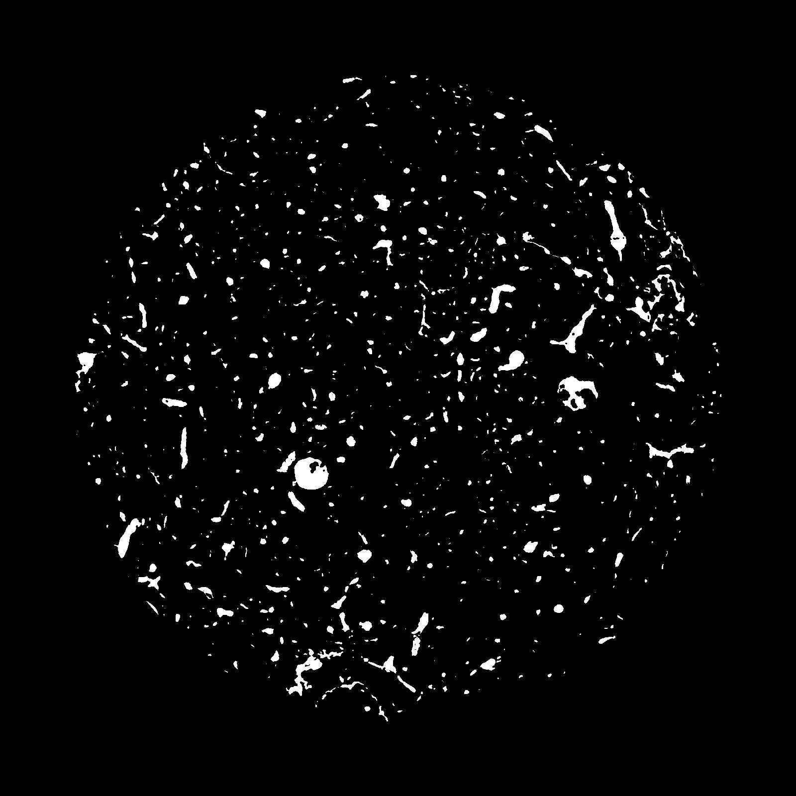
| XY Plane |
|
|---|
|
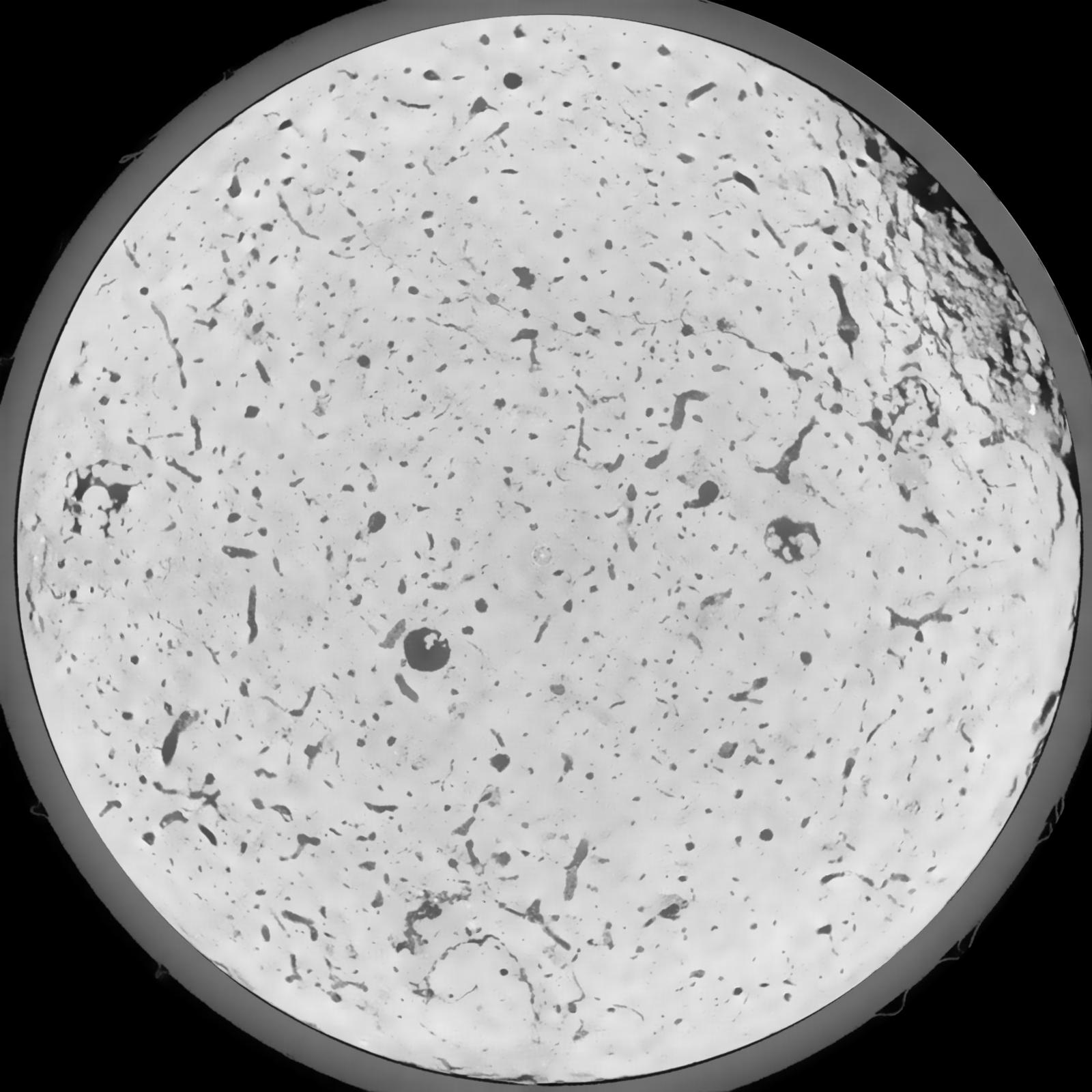
| XY Plane Grey |
|
|---|
|
| Texture | silt loam |
|---|
| Sand | 8.0 |
|---|
| Silt | 79.0 |
|---|
| Clay | 13.0 |
|---|
|
|
Results
| Porosity | Surface | Mean Curvature | Euler | MeanPoreSize | Gamma | PoreDist |
| 0.06087 | 0.568833333 | 0.291388889 | 0.453611111 | 0.0 | 0.6885 | 0.42006575 |
| Opening size | Volume | Surface | MeanCurvature | Euler number |
|---|
| 0.12 | 0.06087 | 0.568833333 | 0.291388889 | 0.453611111 |
| 0.15 | 0.05822 | 0.497166667 | 0.216222222 | 0.1825 |
| 0.18 | 0.05629 | 0.457166667 | 0.18025 | 0.114537037 |
| 0.21 | 0.05454 | 0.427 | 0.158861111 | 0.099259259 |
| 0.24 | 0.05366 | 0.414 | 0.154583333 | 0.123194444 |
| 0.27 | 0.04785 | 0.335166667 | 0.108888889 | 0.069953704 |
| 0.3 | 0.0453 | 0.305666667 | 0.095277778 | 0.063055556 |
| 0.36 | 0.04154 | 0.264833333 | 0.078694444 | 0.051898148 |
| 0.42 | 0.03445 | 0.198833333 | 0.052638889 | 0.031539352 |
| 0.48 | 0.03024 | 0.164766667 | 0.041222222 | 0.022957407 |
| 0.54 | 0.02405 | 0.120783333 | 0.027686111 | 0.016014815 |
| 0.6000000000000001 | 0.02102 | 0.101166667 | 0.022427778 | 0.011781481 |
| 0.6599999999999999 | 0.016 | 0.072283333 | 0.015152778 | 0.009901389 |
| 0.72 | 0.01341 | 0.057683333 | 0.011755556 | 0.006274074 |
| 0.78 | 0.01023 | 0.041733333 | 0.008177778 | 0.004883796 |
| 0.8400000000000001 | 0.008843 | 0.034666667 | 0.006652778 | 0.003431111 |
| 0.8999999999999999 | 0.006573 | 0.024266667 | 0.004422222 | 0.002343843 |
| 1.2 | 0.002257 | 0.006406667 | 0.000926139 | 0.00043669 |
| 1.5 | 0.001057 | 0.002431667 | 0.000275917 | 0.000124769 |
| 1.8 | 0.0006021 | 0.0012495 | 0.000126728 | 0.000035648 |
| 2.1 | 0.0002431 | 0.000455667 | 0.000044381 | 0.000017824 |
| 2.7 | 0.00008352 | 0.000129295 | 0.00001016 | 0.000002241 |
Reference: An open Soil Structure Library based on X-ray CT data
 Soil Structure Library