General Information
Internal Identifier CG_G3_O_a
| Soil Type | Chernozem |
|---|
| Classification | WRB |
|---|
|
| Location | Bernburg (Westerfeld) |
|---|
| Latitude | 51.820 |
|---|
| Longitude | 11.700 |
|---|
|
| Landuse | agricultural crop rotation |
|---|
| Tillage | reduced tillage |
|---|
| Crop | winter wheat, maize, winter wheat, winter rape, winter barley |
|---|
|
| Sampling Depth | 13.0 |
|---|
| Sample Height | 10.0 |
|---|
| Sampling Date | March 28, 2017 |
|---|
| Voxel size | 0.06 |
|---|
| Pores white? | True |
|---|
|
| XY Plane |
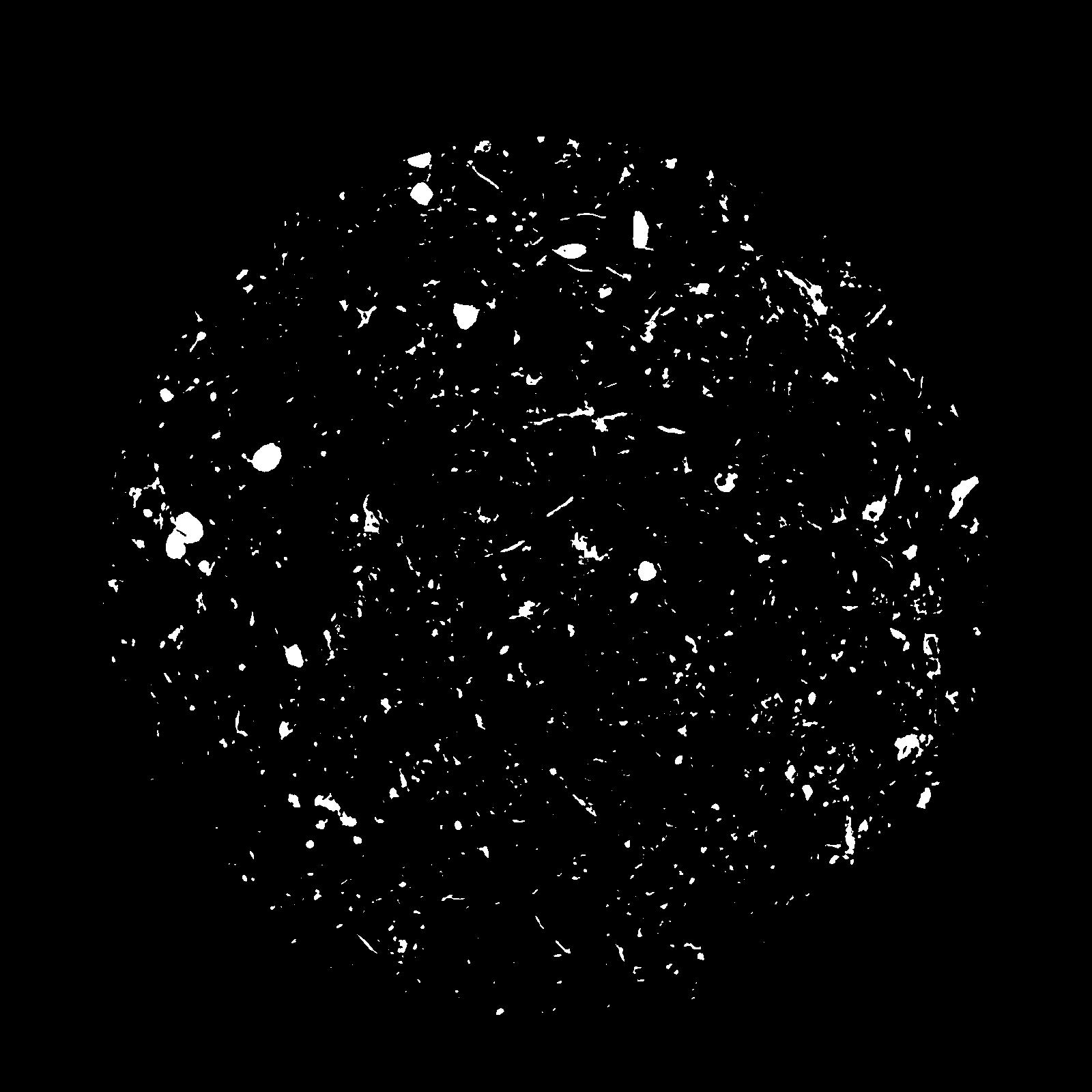
|
|---|
|
| XY Plane Grey |
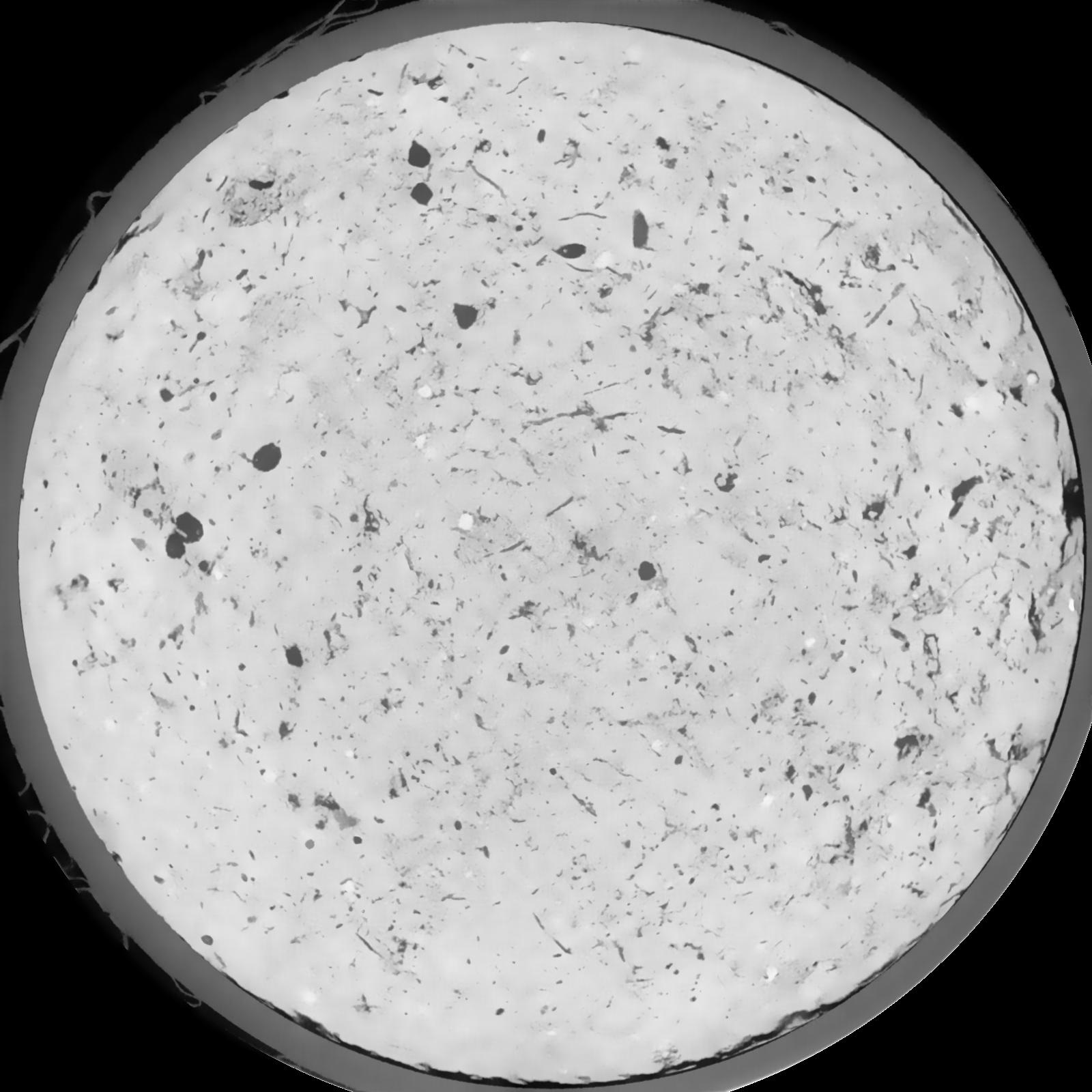
|
|---|
|
| Texture | silt loam |
|---|
| Sand | 8.0 |
|---|
| Silt | 79.0 |
|---|
| Clay | 13.0 |
|---|
|
|
Results
| Porosity | Surface | Mean Curvature | Euler | MeanPoreSize | Gamma | PoreDist |
| 0.04269 | 0.349333333 | 0.230861111 | 0.581018519 | 0.0 | 0.54 | 0.518939827 |
| Opening size | Volume | Surface | MeanCurvature | Euler number |
|---|
| 0.12 | 0.04269 | 0.349333333 | 0.230861111 | 0.581018519 |
| 0.15 | 0.04043 | 0.2845 | 0.145277778 | 0.204444444 |
| 0.18 | 0.03863 | 0.2455 | 0.105527778 | 0.109537037 |
| 0.21 | 0.03717 | 0.219333333 | 0.085222222 | 0.084074074 |
| 0.24 | 0.03654 | 0.209833333 | 0.081722222 | 0.099212963 |
| 0.27 | 0.03272 | 0.1559 | 0.047111111 | 0.042639815 |
| 0.3 | 0.0312 | 0.1381 | 0.0385 | 0.035127778 |
| 0.36 | 0.02922 | 0.11615 | 0.029083333 | 0.025396759 |
| 0.42 | 0.02608 | 0.086683333 | 0.016966667 | 0.011531019 |
| 0.48 | 0.02441 | 0.073466667 | 0.012641667 | 0.007530093 |
| 0.54 | 0.02213 | 0.057866667 | 0.008077778 | 0.004678241 |
| 0.6000000000000001 | 0.0211 | 0.05135 | 0.006386111 | 0.003109954 |
| 0.6599999999999999 | 0.01958 | 0.043333333 | 0.004561111 | 0.002272315 |
| 0.72 | 0.01885 | 0.039583333 | 0.003816667 | 0.00129213 |
| 0.78 | 0.01796 | 0.0359 | 0.003227778 | 0.001113889 |
| 0.8400000000000001 | 0.0175 | 0.0339 | 0.002905556 | 0.000721806 |
| 0.8999999999999999 | 0.01666 | 0.030883333 | 0.002478167 | 0.000668333 |
| 1.2 | 0.01398 | 0.0228 | 0.001577278 | 0.000374269 |
| 1.5 | 0.0116 | 0.017183333 | 0.001088583 | 0.000249509 |
| 1.8 | 0.009522 | 0.013255 | 0.000831944 | 0.00016931 |
| 2.1 | 0.007326 | 0.00935 | 0.000554444 | 0.000142579 |
| 2.7 | 0.004881 | 0.005606667 | 0.000307444 | 0.00006238 |
| 3.3000000000000003 | 0.00303 | 0.00328 | 0.000174836 | 0.000026733 |
| 3.9 | 0.001824 | 0.001893333 | 0.000096239 | 0.000008911 |
| 4.5 | 0.0008128 | 0.0008265 | 0.000044911 | 0.000008911 |
| 5.1 | 0.0004031 | 0.000366833 | 0.000017644 | 0.000002591 |
| 5.699999999999999 | 0.00035 | 0.000330667 | 0.000016575 | 0.000002591 |
Reference: An open Soil Structure Library based on X-ray CT data
 Soil Structure Library