General Information
Internal Identifier CG_G4_O_a
| Soil Type | Chernozem |
|---|
| Classification | WRB |
|---|
|
| Location | Bernburg (Westerfeld) |
|---|
| Latitude | 51.820 |
|---|
| Longitude | 11.700 |
|---|
|
| Landuse | agricultural crop rotation |
|---|
| Tillage | reduced tillage |
|---|
| Crop | winter wheat, maize, winter wheat, winter rape, winter barley |
|---|
|
| Sampling Depth | 13.0 |
|---|
| Sample Height | 10.0 |
|---|
| Sampling Date | March 28, 2017 |
|---|
| Voxel size | 0.06 |
|---|
| Pores white? | True |
|---|
|
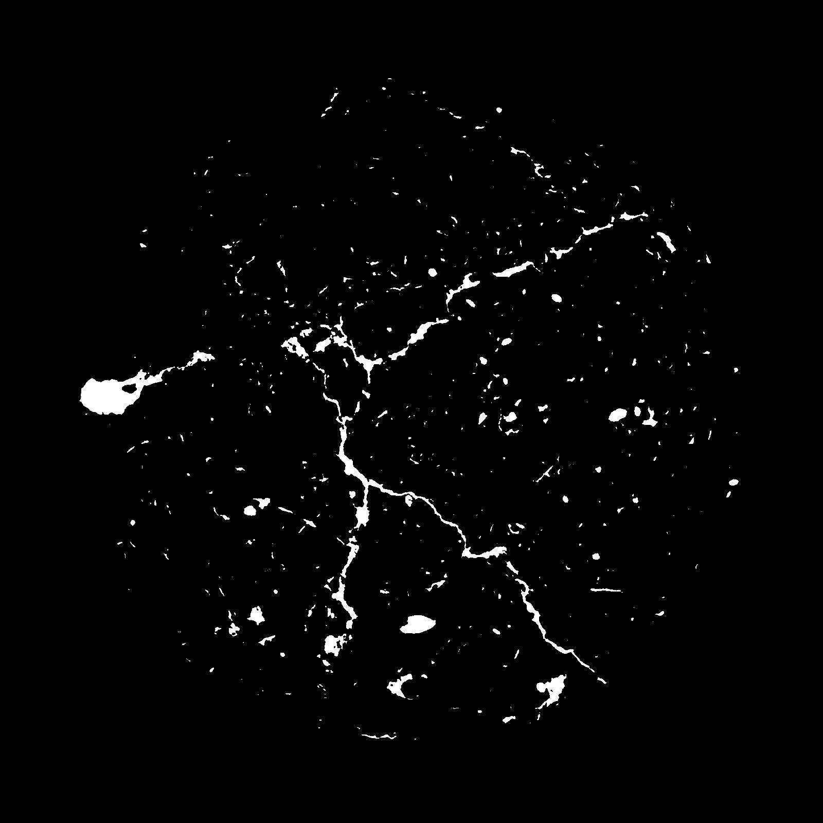
| XY Plane |
|
|---|
|
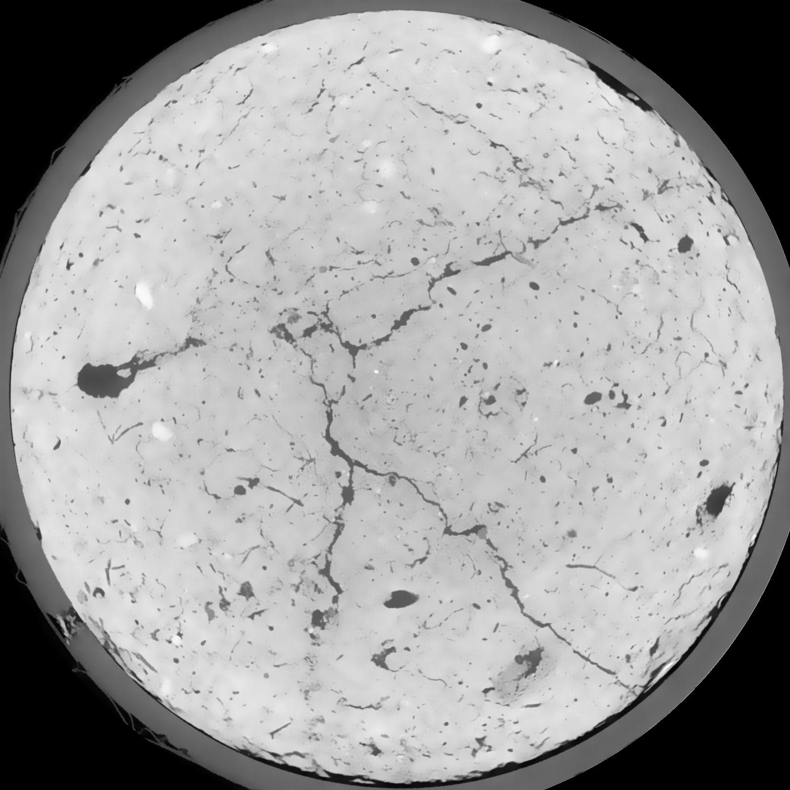
| XY Plane Grey |
|
|---|
|
| Texture | silt loam |
|---|
| Sand | 8.0 |
|---|
| Silt | 79.0 |
|---|
| Clay | 13.0 |
|---|
|
|
Results
| Porosity | Surface | Mean Curvature | Euler | MeanPoreSize | Gamma | PoreDist |
| 0.04439 | 0.329 | 0.162166667 | 0.355555556 | 0.0 | 0.6192 | 0.632147243 |
| Opening size | Volume | Surface | MeanCurvature | Euler number |
|---|
| 0.12 | 0.04439 | 0.329 | 0.162166667 | 0.355555556 |
| 0.15 | 0.04257 | 0.276166667 | 0.099972222 | 0.101574074 |
| 0.18 | 0.04105 | 0.2465 | 0.076472222 | 0.050324074 |
| 0.21 | 0.03988 | 0.227333333 | 0.064972222 | 0.04185 |
| 0.24 | 0.03931 | 0.219333333 | 0.063111111 | 0.054490741 |
| 0.27 | 0.03598 | 0.1775 | 0.042138889 | 0.02317963 |
| 0.3 | 0.0345 | 0.162033333 | 0.036527778 | 0.020363426 |
| 0.36 | 0.03252 | 0.142116667 | 0.030111111 | 0.017226852 |
| 0.42 | 0.02888 | 0.111366667 | 0.020297222 | 0.009874537 |
| 0.48 | 0.02681 | 0.096216667 | 0.016227778 | 0.007058333 |
| 0.54 | 0.02402 | 0.0785 | 0.01185 | 0.005516667 |
| 0.6000000000000001 | 0.0227 | 0.07085 | 0.010216667 | 0.003947963 |
| 0.6599999999999999 | 0.02037 | 0.059416667 | 0.008061111 | 0.003841019 |
| 0.72 | 0.01915 | 0.05335 | 0.006952778 | 0.002468611 |
| 0.78 | 0.01746 | 0.046216667 | 0.005797222 | 0.002343843 |
| 0.8400000000000001 | 0.01662 | 0.042583333 | 0.005233333 | 0.001737824 |
| 0.8999999999999999 | 0.01505 | 0.036483333 | 0.004255556 | 0.001541759 |
| 1.2 | 0.01082 | 0.0222 | 0.002227611 | 0.000748611 |
| 1.5 | 0.007683 | 0.01355 | 0.001186528 | 0.000374301 |
| 1.8 | 0.005667 | 0.00879 | 0.000678028 | 0.000204972 |
| 2.1 | 0.004241 | 0.005893333 | 0.000395694 | 0.000115856 |
| 2.7 | 0.002691 | 0.003341667 | 0.000199983 | 0.000035648 |
| 3.3000000000000003 | 0.001486 | 0.00175 | 0.0001032 | 0.000017824 |
| 3.9 | 0.0005755 | 0.0005705 | 0.000025131 | 0.000001145 |
| 4.5 | 0.0001822 | 0.0002035 | 0.000010694 | 0.000001145 |
Reference: An open Soil Structure Library based on X-ray CT data
 Soil Structure Library