General Information
Internal Identifier CG_P1_O_a
| Soil Type | Chernozem |
|---|
| Classification | WRB |
|---|
|
| Location | Bernburg (Westerfeld) |
|---|
| Latitude | 51.820 |
|---|
| Longitude | 11.700 |
|---|
|
| Landuse | agricultural crop rotation |
|---|
| Tillage | conventional tillage |
|---|
| Crop | winter wheat, maize, winter wheat, winter rape, winter barley |
|---|
|
| Sampling Depth | 13.0 |
|---|
| Sample Height | 10.0 |
|---|
| Sampling Date | March 28, 2017 |
|---|
| Voxel size | 0.06 |
|---|
| Pores white? | True |
|---|
|
| XY Plane |
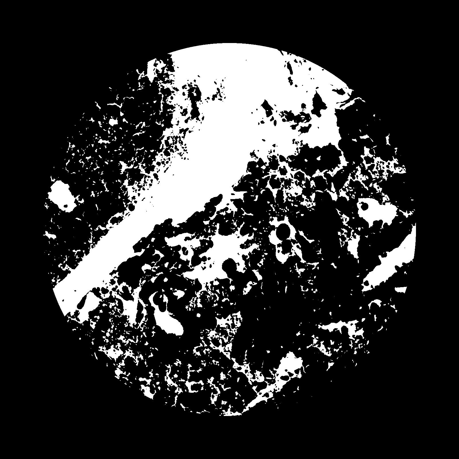
|
|---|
|
| XY Plane Grey |
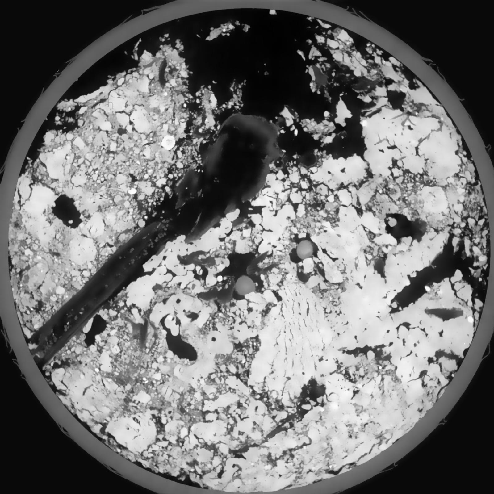
|
|---|
|
| Texture | silt loam |
|---|
| Sand | 8.0 |
|---|
| Silt | 79.0 |
|---|
| Clay | 13.0 |
|---|
|
|
Results
| Porosity | Surface | Mean Curvature | Euler | MeanPoreSize | Gamma | PoreDist |
| 0.2713 | 1.096666667 | 0.230055556 | -0.091898148 | 0.0 | 0.9562 | 0.42608367 |
| Opening size | Volume | Surface | MeanCurvature | Euler number |
|---|
| 0.12 | 0.2713 | 1.096666667 | 0.230055556 | -0.091898148 |
| 0.15 | 0.2682 | 0.99 | 0.15925 | -0.146898148 |
| 0.18 | 0.2649 | 0.932166667 | 0.130861111 | -0.161712963 |
| 0.21 | 0.2616 | 0.885833333 | 0.115222222 | -0.109675926 |
| 0.24 | 0.2597 | 0.86 | 0.115277778 | -0.025253704 |
| 0.27 | 0.2481 | 0.737 | 0.085527778 | -0.031803241 |
| 0.3 | 0.2422 | 0.683 | 0.076027778 | -0.010630556 |
| 0.36 | 0.2346 | 0.612666667 | 0.06475 | 0.021074537 |
| 0.42 | 0.2192 | 0.498833333 | 0.044166667 | 0.016806019 |
| 0.48 | 0.2101 | 0.4415 | 0.035555556 | 0.014150463 |
| 0.54 | 0.1977 | 0.372666667 | 0.025361111 | 0.012306019 |
| 0.6000000000000001 | 0.1918 | 0.342833333 | 0.021525 | 0.009534722 |
| 0.6599999999999999 | 0.1811 | 0.297666667 | 0.016811111 | 0.008679167 |
| 0.72 | 0.1757 | 0.275 | 0.014455556 | 0.006344444 |
| 0.78 | 0.1681 | 0.2485 | 0.012316667 | 0.005649537 |
| 0.8400000000000001 | 0.1644 | 0.235 | 0.011102778 | 0.003840602 |
| 0.8999999999999999 | 0.1569 | 0.2125 | 0.009386111 | 0.003457454 |
| 1.2 | 0.134 | 0.153316667 | 0.005866667 | 0.001960417 |
| 1.5 | 0.116 | 0.11755 | 0.004155556 | 0.001113889 |
| 1.8 | 0.1019 | 0.095516667 | 0.003519444 | 0.000730694 |
| 2.1 | 0.08832 | 0.07605 | 0.002786111 | 0.000605926 |
| 2.7 | 0.06803 | 0.051016667 | 0.0019205 | 0.00035644 |
| 3.3000000000000003 | 0.05116 | 0.032116667 | 0.001080528 | 0.000258417 |
| 3.9 | 0.0376 | 0.01825 | 0.000429333 | 0.000115843 |
| 4.5 | 0.03099 | 0.012945 | 0.000236853 | 0.000044555 |
| 5.1 | 0.0278 | 0.010861667 | 0.000182853 | 0.000035644 |
| 5.699999999999999 | 0.02464 | 0.0091 | 0.000149169 | 0.000026733 |
| 6.3 | 0.02235 | 0.00781 | 0.000105328 | 0.000017822 |
| 6.8999999999999995 | 0.02089 | 0.00742 | 0.000103189 | 0.000008911 |
| 7.5 | 0.01846 | 0.00678 | 0.000108 | 0.000008911 |
| 8.1 | 0.01638 | 0.006218333 | 0.000105861 | 0.000008911 |
| 8.700000000000001 | 0.01306 | 0.00488 | 0.000075922 | 0.000002655 |
| 9.3 | 0.00984 | 0.004058333 | 0.000074853 | 0.000002655 |
| 9.9 | 0.005606 | 0.002388333 | 0.000048653 | 0.000002655 |
| 10.5 | 0.004844 | 0.002201667 | 0.000048119 | 0.000002655 |
| 11.1 | 0.00206 | 0.001084167 | 0.000030475 | 0.000002655 |
Reference: An open Soil Structure Library based on X-ray CT data
 Soil Structure Library