General Information
Internal Identifier CG_P2_O_b
| Soil Type | Chernozem |
|---|
| Classification | WRB |
|---|
|
| Location | Bernburg (Westerfeld) |
|---|
| Latitude | 51.820 |
|---|
| Longitude | 11.700 |
|---|
|
| Landuse | agricultural crop rotation |
|---|
| Tillage | conventional tillage |
|---|
| Crop | winter wheat, maize, winter wheat, winter rape, winter barley |
|---|
|
| Sampling Depth | 13.0 |
|---|
| Sample Height | 10.0 |
|---|
| Sampling Date | March 28, 2017 |
|---|
| Voxel size | 0.06 |
|---|
| Pores white? | True |
|---|
|
| XY Plane |
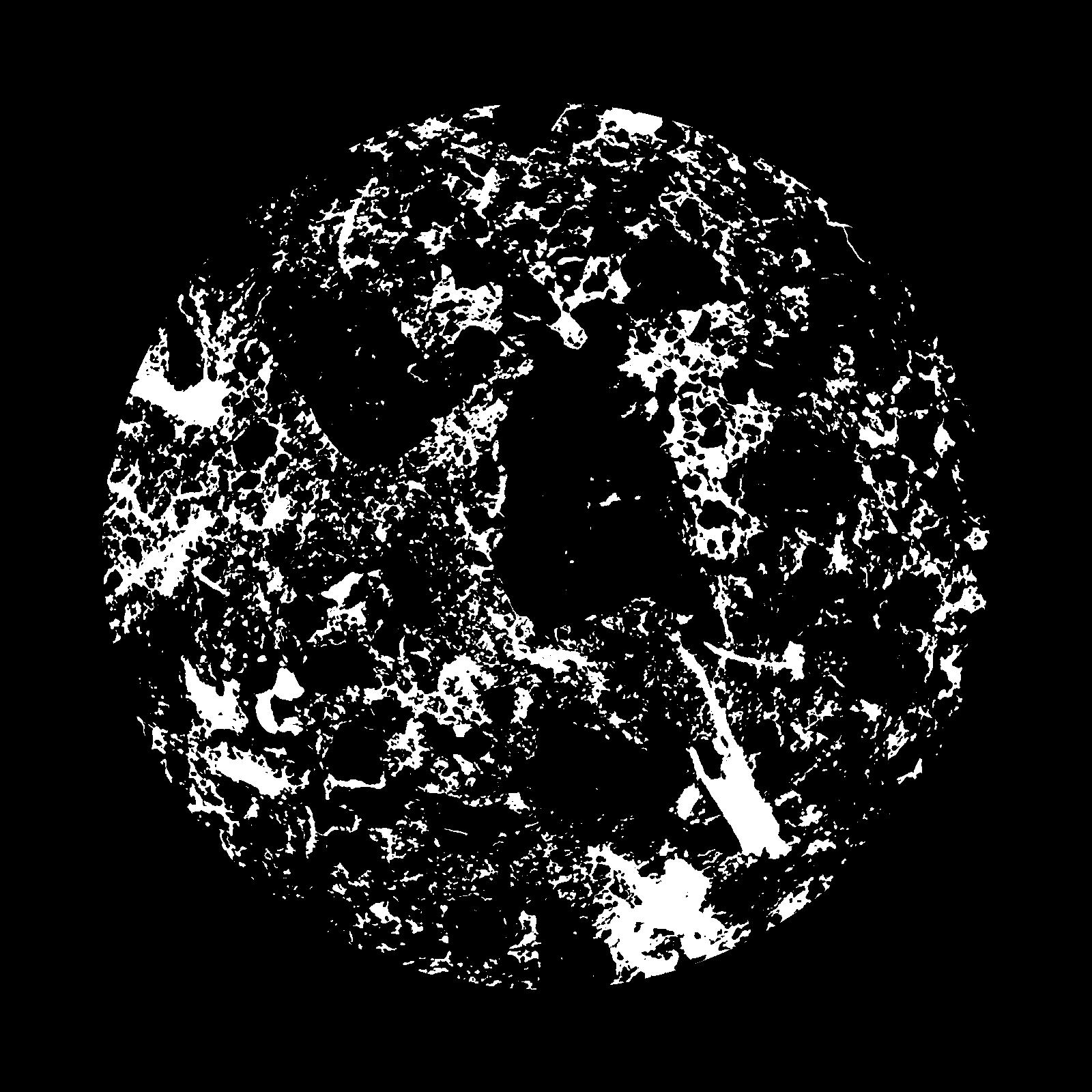
|
|---|
|
| XY Plane Grey |
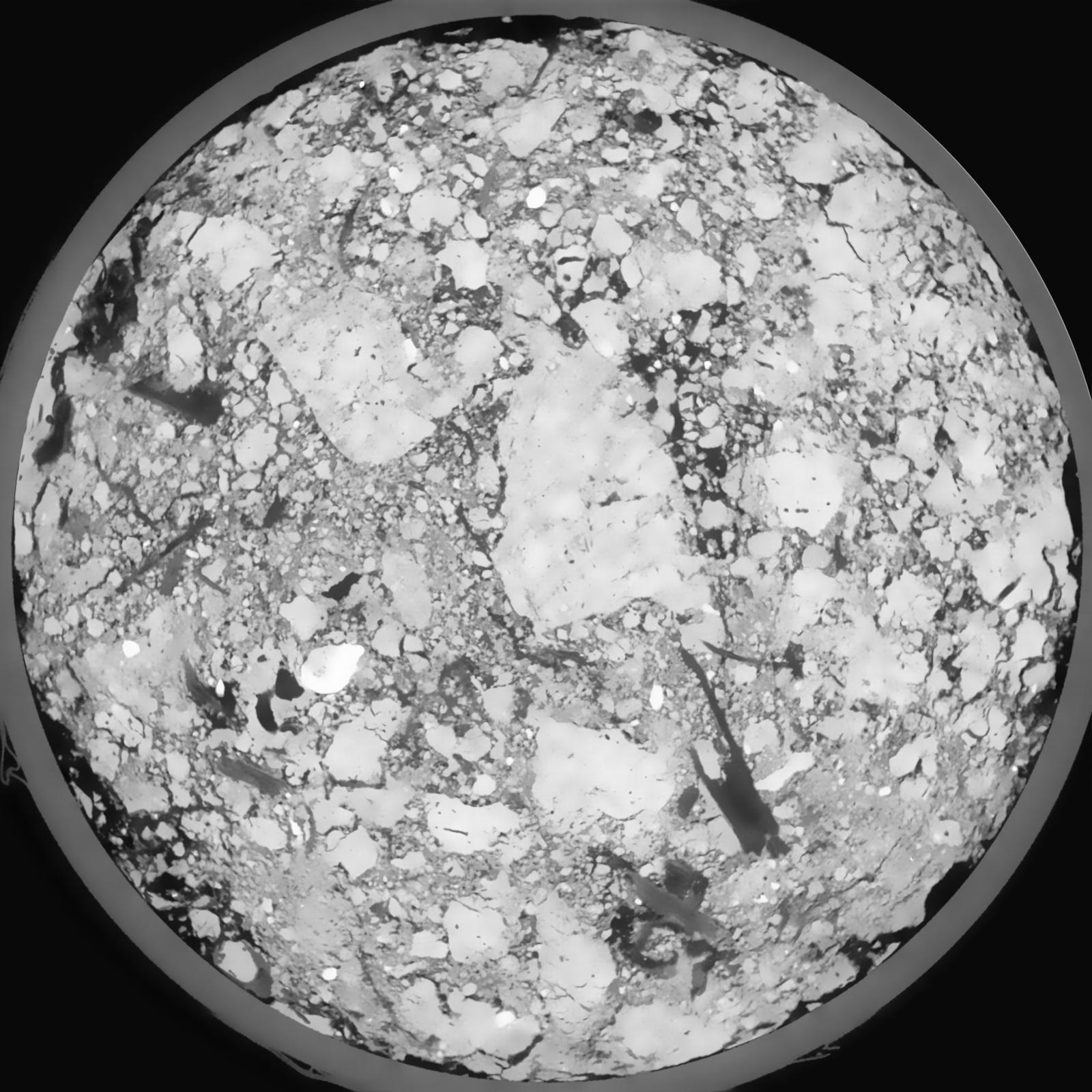
|
|---|
|
| Texture | silt loam |
|---|
| Sand | 8.0 |
|---|
| Silt | 79.0 |
|---|
| Clay | 13.0 |
|---|
|
|
Results
| Porosity | Surface | Mean Curvature | Euler | MeanPoreSize | Gamma | PoreDist |
| 0.2377 | 1.399 | 0.389444444 | -0.29337963 | 0.0 | 0.9428 | 0.339177947 |
| Opening size | Volume | Surface | MeanCurvature | Euler number |
|---|
| 0.12 | 0.2377 | 1.399 | 0.389444444 | -0.29337963 |
| 0.15 | 0.2333 | 1.247833333 | 0.281944444 | -0.340462963 |
| 0.18 | 0.2283 | 1.162666667 | 0.238361111 | -0.333842593 |
| 0.21 | 0.2234 | 1.090833333 | 0.213333333 | -0.224768519 |
| 0.24 | 0.2204 | 1.050833333 | 0.213638889 | -0.070555556 |
| 0.27 | 0.202 | 0.849 | 0.159055556 | -0.041145833 |
| 0.3 | 0.1927 | 0.759666667 | 0.139888889 | 0.002468565 |
| 0.36 | 0.1809 | 0.6465 | 0.115972222 | 0.055324074 |
| 0.42 | 0.1582 | 0.462 | 0.068583333 | 0.042865741 |
| 0.48 | 0.1464 | 0.378 | 0.049055556 | 0.031966667 |
| 0.54 | 0.1316 | 0.285833333 | 0.027888889 | 0.01920463 |
| 0.6000000000000001 | 0.1255 | 0.2515 | 0.021316667 | 0.013982407 |
| 0.6599999999999999 | 0.1153 | 0.203 | 0.013311111 | 0.009705093 |
| 0.72 | 0.1108 | 0.182 | 0.010152778 | 0.006585648 |
| 0.78 | 0.1047 | 0.158933333 | 0.007288889 | 0.004758796 |
| 0.8400000000000001 | 0.1021 | 0.148866667 | 0.006141667 | 0.003591435 |
| 0.8999999999999999 | 0.09713 | 0.13305 | 0.004636111 | 0.00275375 |
| 1.2 | 0.08251 | 0.096233333 | 0.002658556 | 0.001354583 |
| 1.5 | 0.07052 | 0.07295 | 0.001659194 | 0.000677315 |
| 1.8 | 0.06205 | 0.06075 | 0.001472583 | 0.000276264 |
| 2.1 | 0.05334 | 0.050116667 | 0.00139825 | 0.000213884 |
| 2.7 | 0.03905 | 0.033966667 | 0.001017 | 0.000062384 |
| 3.3000000000000003 | 0.0284 | 0.024316667 | 0.000865167 | 0.000071296 |
| 3.9 | 0.01879 | 0.015213333 | 0.000551806 | 0.000053472 |
| 4.5 | 0.0124 | 0.0097 | 0.000366806 | 0.000035647 |
| 5.1 | 0.006545 | 0.004791667 | 0.000184472 | 0.000026735 |
| 5.699999999999999 | 0.002835 | 0.001558667 | 0.000040103 | 0.000002335 |
| 6.3 | 0.002363 | 0.001246 | 0.000031547 | 0.000004669 |
| 6.8999999999999995 | 0.001926 | 0.001052333 | 0.000028875 | 0.000004669 |
| 7.5 | 0.001725 | 0.000961833 | 0.00002727 | 0.000002335 |
| 8.1 | 0.001521 | 0.000871833 | 0.000025666 | 0.000002335 |
| 8.700000000000001 | 0.0012 | 0.000732 | 0.000023527 | 0.000002335 |
Reference: An open Soil Structure Library based on X-ray CT data
 Soil Structure Library