General Information
Internal Identifier CG_G3_U_b
| Soil Type | Chernozem |
|---|
| Classification | WRB |
|---|
|
| Location | Bernburg (Westerfeld) |
|---|
| Latitude | 51.820 |
|---|
| Longitude | 11.700 |
|---|
|
| Landuse | agricultural crop rotation |
|---|
| Tillage | reduced tillage |
|---|
| Crop | winter wheat, maize, winter wheat, winter rape, winter barley |
|---|
|
| Sampling Depth | 28.0 |
|---|
| Sample Height | 10.0 |
|---|
| Sampling Date | March 28, 2017 |
|---|
| Voxel size | 0.06 |
|---|
| Pores white? | True |
|---|
|
| XY Plane |
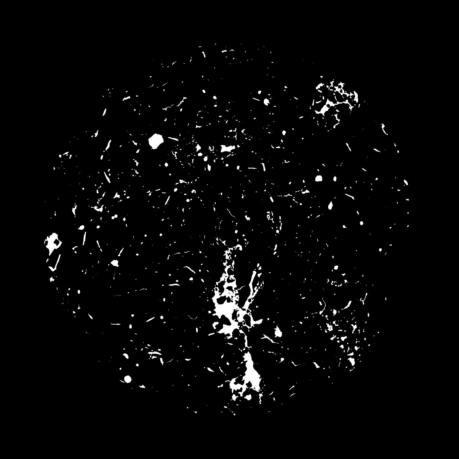
|
|---|
|
| XY Plane Grey |
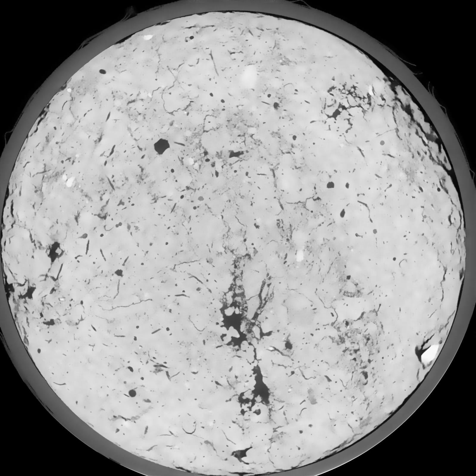
|
|---|
|
| Texture | silt loam |
|---|
| Sand | 8.0 |
|---|
| Silt | 79.0 |
|---|
| Clay | 13.0 |
|---|
|
|
Results
| Porosity | Surface | Mean Curvature | Euler | MeanPoreSize | Gamma | PoreDist |
| 0.0436 | 0.370333333 | 0.220277778 | 0.465277778 | 0.0 | 0.5281 | 0.54156511 |
| Opening size | Volume | Surface | MeanCurvature | Euler number |
|---|
| 0.12 | 0.0436 | 0.370333333 | 0.220277778 | 0.465277778 |
| 0.15 | 0.041 | 0.296166667 | 0.1355 | 0.155277778 |
| 0.18 | 0.03893 | 0.253666667 | 0.098527778 | 0.079259259 |
| 0.21 | 0.03739 | 0.227166667 | 0.079944444 | 0.062453704 |
| 0.24 | 0.03672 | 0.217166667 | 0.076944444 | 0.081527778 |
| 0.27 | 0.03285 | 0.1642 | 0.045111111 | 0.031032407 |
| 0.3 | 0.03134 | 0.147216667 | 0.037666667 | 0.025426389 |
| 0.36 | 0.0294 | 0.1264 | 0.029638889 | 0.020052315 |
| 0.42 | 0.02613 | 0.0973 | 0.019169444 | 0.010159722 |
| 0.48 | 0.02429 | 0.083433333 | 0.015136111 | 0.007067593 |
| 0.54 | 0.02172 | 0.066216667 | 0.010497222 | 0.005187037 |
| 0.6000000000000001 | 0.02048 | 0.058583333 | 0.008647222 | 0.003716389 |
| 0.6599999999999999 | 0.01849 | 0.047833333 | 0.006211111 | 0.002967778 |
| 0.72 | 0.01756 | 0.042916667 | 0.005183333 | 0.001871574 |
| 0.78 | 0.0164 | 0.037816667 | 0.004255556 | 0.001613102 |
| 0.8400000000000001 | 0.01585 | 0.03535 | 0.003847222 | 0.001158565 |
| 0.8999999999999999 | 0.01482 | 0.031333333 | 0.003191667 | 0.000998148 |
| 1.2 | 0.01193 | 0.021816667 | 0.00190525 | 0.00057037 |
| 1.5 | 0.009691 | 0.01594 | 0.001233639 | 0.000374315 |
| 1.8 | 0.007571 | 0.011421667 | 0.000836861 | 0.000169333 |
| 2.1 | 0.005475 | 0.007168333 | 0.000447028 | 0.000115856 |
| 2.7 | 0.003061 | 0.003268333 | 0.000168442 | 0.000035649 |
| 3.3000000000000003 | 0.002213 | 0.002121667 | 0.000093578 | 0.000017825 |
| 3.9 | 0.001623 | 0.001521667 | 0.000069514 | 0.000017825 |
| 4.5 | 0.001134 | 0.0010695 | 0.000050264 | 0.000006475 |
| 5.1 | 0.0002905 | 0.000292833 | 0.000014973 | 0.000002159 |
Reference: An open Soil Structure Library based on X-ray CT data
 Soil Structure Library