General Information
Internal Identifier CG_G1_U_b_3cm_b
| Soil Type | Chernozem |
|---|
| Classification | WRB |
|---|
|
| Location | Bernburg (Westerfeld) |
|---|
| Latitude | 51.820 |
|---|
| Longitude | 11.700 |
|---|
|
| Landuse | agricultural crop rotation |
|---|
| Tillage | reduced tillage |
|---|
| Crop | winter wheat, maize, winter wheat, winter rape, winter barley |
|---|
|
| Sampling Depth | 31.0 |
|---|
| Sample Height | 3.0 |
|---|
| Sampling Date | March 28, 2017 |
|---|
| Voxel size | 0.02 |
|---|
| Pores white? | True |
|---|
|
| XY Plane |
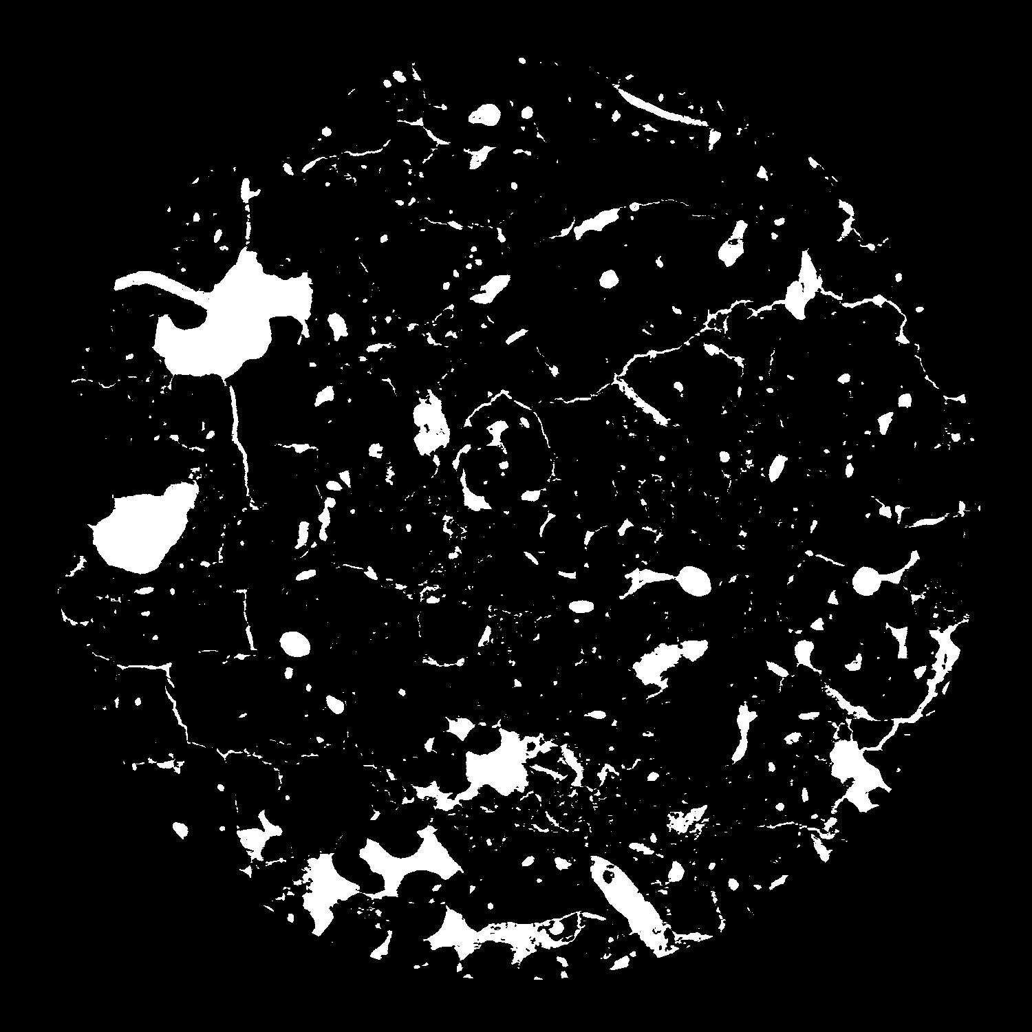
|
|---|
|
| XY Plane Grey |
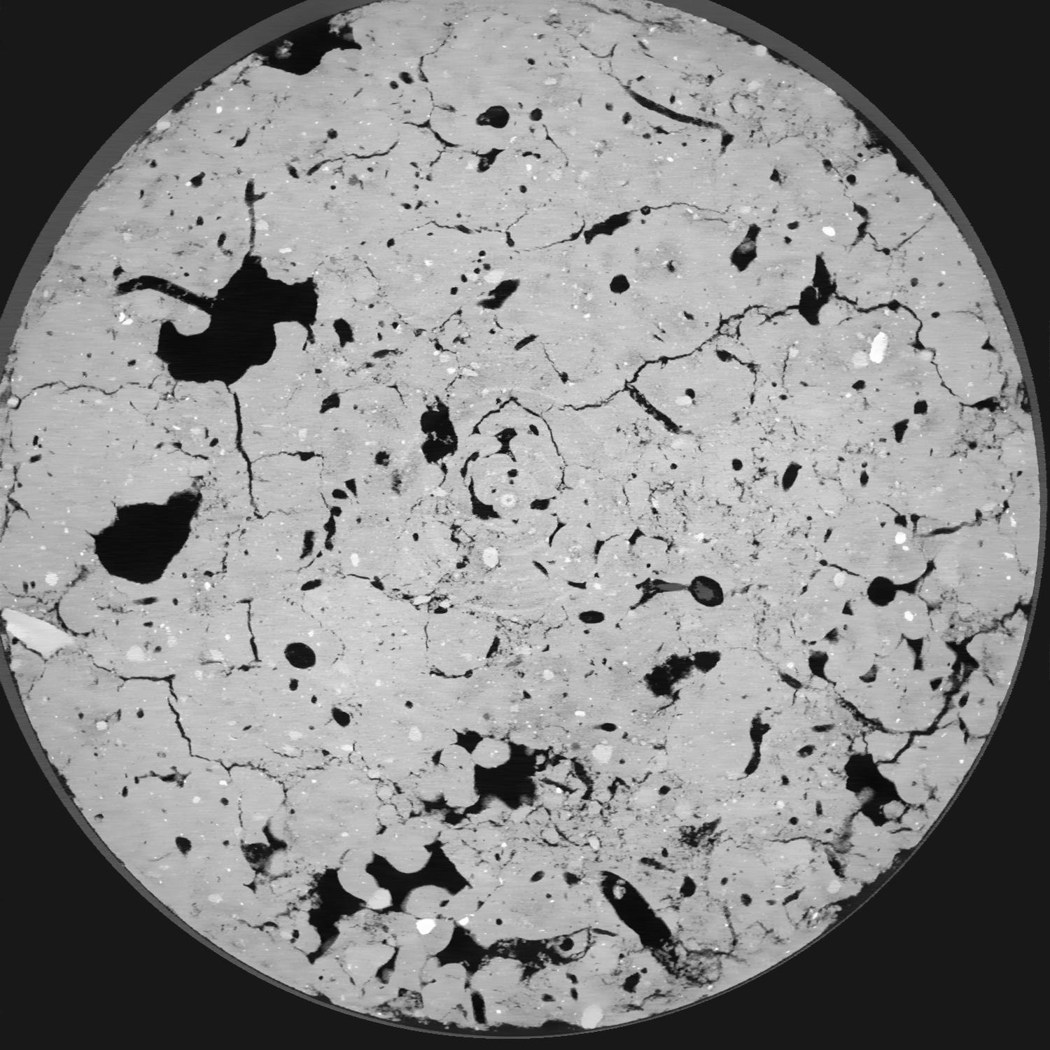
|
|---|
|
| Texture | silt loam |
|---|
| Sand | 8.0 |
|---|
| Silt | 79.0 |
|---|
| Clay | 13.0 |
|---|
|
|
Results
| Porosity | Surface | Mean Curvature | Euler | MeanPoreSize | Gamma | PoreDist |
| 0.08826 | 1.569 | 1.93575 | 10.0025 | 0.0 | 0.7229 | 0.172256735 |
| Opening size | Volume | Surface | MeanCurvature | Euler number |
|---|
| 0.04 | 0.08826 | 1.569 | 1.93575 | 10.0025 |
| 0.05 | 0.08558 | 1.3365 | 1.248 | 2.955 |
| 0.06 | 0.08339 | 1.218 | 1.03775 | 1.8925 |
| 0.07 | 0.08187 | 1.148 | 0.934 | 1.83375 |
| 0.08 | 0.08111 | 1.117 | 0.9185 | 2.29125 |
| 0.09000000000000001 | 0.0766 | 0.9515 | 0.6915 | 1.41 |
| 0.1 | 0.07477 | 0.894 | 0.626 | 1.27875 |
| 0.12000000000000001 | 0.07226 | 0.817 | 0.5465 | 1.0736875 |
| 0.13999999999999999 | 0.06723 | 0.6875 | 0.4155 | 0.7405625 |
| 0.16 | 0.06391 | 0.612 | 0.3485 | 0.587225 |
| 0.18 | 0.0588 | 0.5095 | 0.262 | 0.4805625 |
| 0.19999999999999998 | 0.05604 | 0.4575 | 0.22215 | 0.35705 |
| 0.22 | 0.05132 | 0.37945 | 0.16535 | 0.30685 |
| 0.24 | 0.04878 | 0.3373 | 0.136 | 0.1978375 |
| 0.26 | 0.0456 | 0.29305 | 0.10845 | 0.1627375 |
| 0.28 | 0.04397 | 0.26955 | 0.094525 | 0.113525 |
| 0.30000000000000004 | 0.04112 | 0.23425 | 0.074525 | 0.08489875 |
| 0.4 | 0.03322 | 0.15075 | 0.035625 | 0.03921375 |
| 0.5 | 0.02826 | 0.1109 | 0.02116375 | 0.0198025 |
| 0.6 | 0.02473 | 0.0887 | 0.0152935 | 0.01254875 |
| 0.7000000000000001 | 0.02138 | 0.07045 | 0.01105825 | 0.01058775 |
| 0.9 | 0.01644 | 0.04722 | 0.0062585 | 0.0041175 |
| 1.1 | 0.01286 | 0.034915 | 0.004392 | 0.003725375 |
| 1.3 | 0.008639 | 0.02232 | 0.002749 | 0.0013725 |
| 1.5 | 0.00579 | 0.014715 | 0.001799925 | 0.000784287 |
| 1.7 | 0.002992 | 0.007385 | 0.00092545 | 0.000784287 |
| 1.9 | 0.001807 | 0.0046775 | 0.000635275 | 0.000392137 |
| 2.1 | 0.0004106 | 0.001089 | 0.000152935 | 0.000067174 |
Reference: An open Soil Structure Library based on X-ray CT data
 Soil Structure Library