General Information
Internal Identifier CG_G1_U_b_3cm_c
| Soil Type | Chernozem |
|---|
| Classification | WRB |
|---|
|
| Location | Bernburg (Westerfeld) |
|---|
| Latitude | 51.820 |
|---|
| Longitude | 11.700 |
|---|
|
| Landuse | agricultural crop rotation |
|---|
| Tillage | reduced tillage |
|---|
| Crop | winter wheat, maize, winter wheat, winter rape, winter barley |
|---|
|
| Sampling Depth | 31.0 |
|---|
| Sample Height | 3.0 |
|---|
| Sampling Date | March 28, 2017 |
|---|
| Voxel size | 0.02 |
|---|
| Pores white? | True |
|---|
|
| XY Plane |
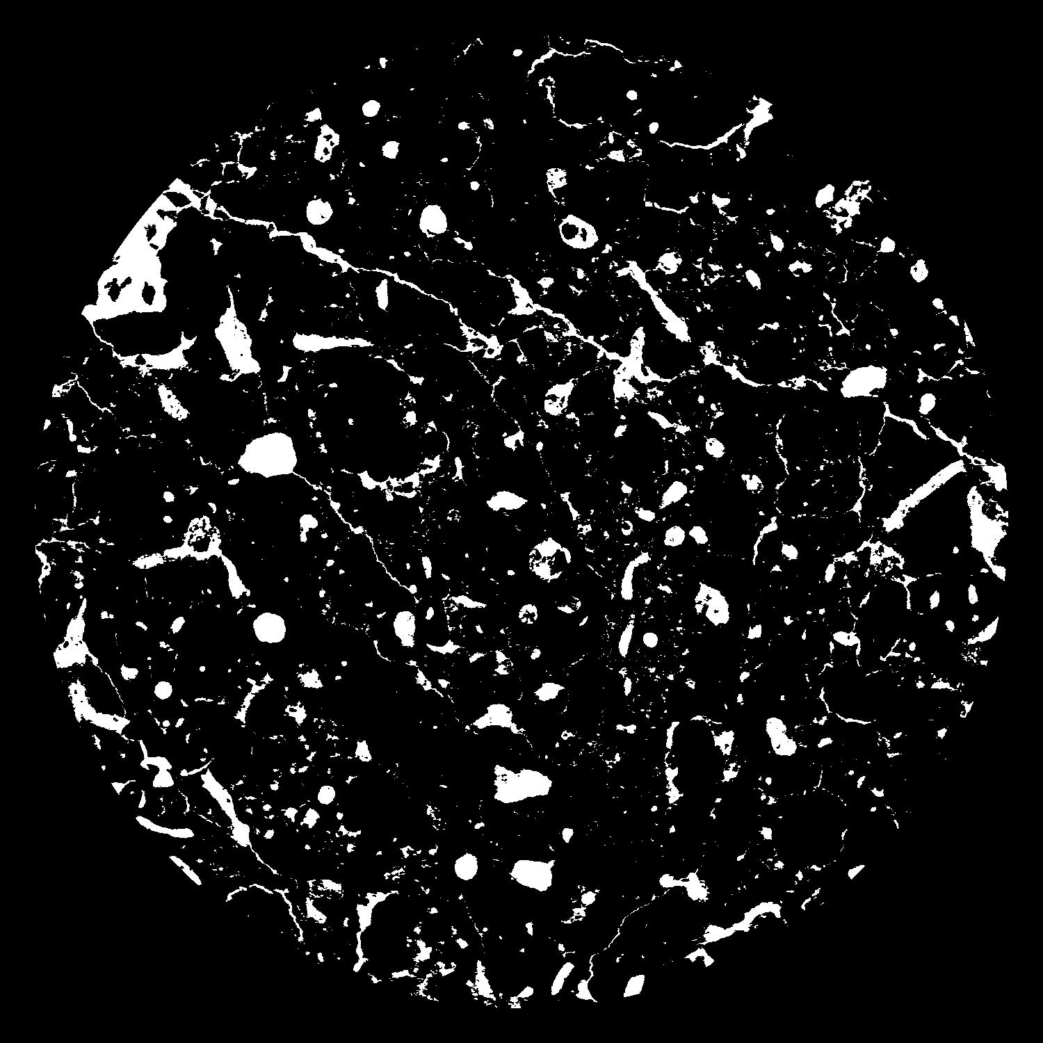
|
|---|
|
| XY Plane Grey |
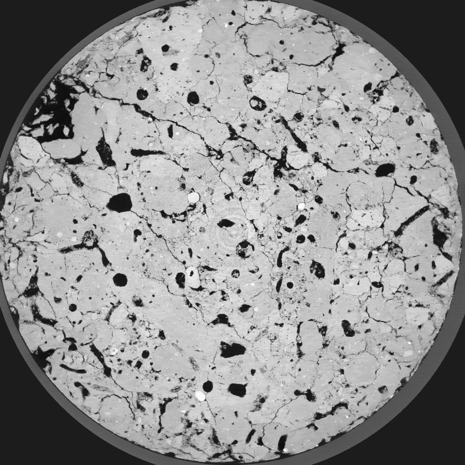
|
|---|
|
| Texture | silt loam |
|---|
| Sand | 8.0 |
|---|
| Silt | 79.0 |
|---|
| Clay | 13.0 |
|---|
|
|
Results
| Porosity | Surface | Mean Curvature | Euler | MeanPoreSize | Gamma | PoreDist |
| 0.1277 | 2.1575 | 2.2705 | 9.8675 | 0.0 | 0.8216 | 0.144954764 |
| Opening size | Volume | Surface | MeanCurvature | Euler number |
|---|
| 0.04 | 0.1277 | 2.1575 | 2.2705 | 9.8675 |
| 0.05 | 0.1244 | 1.851 | 1.4315 | 1.97625 |
| 0.06 | 0.1216 | 1.702 | 1.19275 | 0.9571875 |
| 0.07 | 0.1196 | 1.6115 | 1.0755 | 1.150075 |
| 0.08 | 0.1185 | 1.569 | 1.05925 | 1.86125 |
| 0.09000000000000001 | 0.1122 | 1.3555 | 0.823 | 1.02975 |
| 0.1 | 0.1094 | 1.2745 | 0.7535 | 1.00495 |
| 0.12000000000000001 | 0.1057 | 1.1655 | 0.6665 | 0.961375 |
| 0.13999999999999999 | 0.09778 | 0.9785 | 0.51925 | 0.7070375 |
| 0.16 | 0.09273 | 0.8725 | 0.44475 | 0.586525 |
| 0.18 | 0.08518 | 0.7315 | 0.34725 | 0.529275 |
| 0.19999999999999998 | 0.08124 | 0.662 | 0.30175 | 0.4053 |
| 0.22 | 0.07415 | 0.5525 | 0.234225 | 0.3788625 |
| 0.24 | 0.07039 | 0.4938 | 0.1982 | 0.257625 |
| 0.26 | 0.06532 | 0.4252 | 0.158875 | 0.2145875 |
| 0.28 | 0.0629 | 0.3915 | 0.140175 | 0.1578875 |
| 0.30000000000000004 | 0.05846 | 0.3373 | 0.1107 | 0.12106125 |
| 0.4 | 0.04605 | 0.20835 | 0.052475 | 0.05032 |
| 0.5 | 0.03788 | 0.1427 | 0.02975 | 0.02625375 |
| 0.6 | 0.03206 | 0.1045 | 0.0188155 | 0.01367375 |
| 0.7000000000000001 | 0.02732 | 0.07795 | 0.01215725 | 0.009116 |
| 0.9 | 0.02048 | 0.04608 | 0.00583425 | 0.00328175 |
| 1.1 | 0.01689 | 0.03235 | 0.0034095 | 0.0025525 |
| 1.3 | 0.01513 | 0.027085 | 0.00269475 | 0.00182325 |
| 1.5 | 0.01283 | 0.02027 | 0.001681 | 0.000729287 |
| 1.7 | 0.0113 | 0.016505 | 0.001236125 | 0.000364637 |
| 1.9 | 0.009668 | 0.012915 | 0.0008569 | 0.000182325 |
| 2.1 | 0.008018 | 0.009365 | 0.000484975 | 0.000182325 |
| 2.3 | 0.00761 | 0.008615 | 0.00041205 | 0.000031231 |
| 2.5 | 0.007287 | 0.008345 | 0.000419325 | 0.000031231 |
| 2.7 | 0.007019 | 0.008125 | 0.00044485 | 0.000062463 |
| 2.9 | 0.006777 | 0.007865 | 0.000437575 | 0.000062463 |
| 3.1 | 0.006531 | 0.007625 | 0.000430275 | 0.000364637 |
| 3.3 | 0.006213 | 0.00738 | 0.000422975 | 0.000062463 |
| 3.5 | 0.005284 | 0.00665 | 0.00040475 | 0.000062463 |
| 3.7 | 0.00233 | 0.003389 | 0.0002589 | 0.000062463 |
Reference: An open Soil Structure Library based on X-ray CT data
 Soil Structure Library