General Information
Internal Identifier CG_G3_U_b_3cm_b
| Soil Type | Chernozem |
|---|
| Classification | WRB |
|---|
|
| Location | Bernburg (Westerfeld) |
|---|
| Latitude | 51.820 |
|---|
| Longitude | 11.700 |
|---|
|
| Landuse | agricultural crop rotation |
|---|
| Tillage | reduced tillage |
|---|
| Crop | winter wheat, maize, winter wheat, winter rape, winter barley |
|---|
|
| Sampling Depth | 31.0 |
|---|
| Sample Height | 3.0 |
|---|
| Sampling Date | March 28, 2017 |
|---|
| Voxel size | 0.02 |
|---|
| Pores white? | True |
|---|
|
| XY Plane |
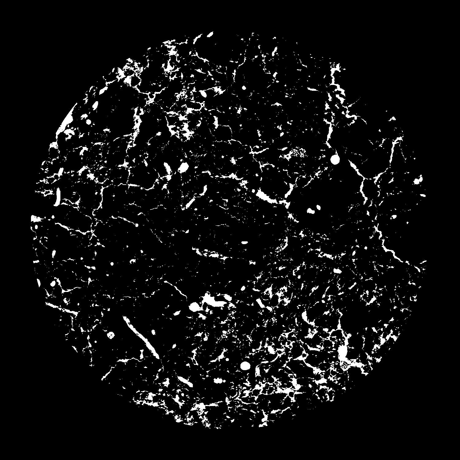
|
|---|
|
| XY Plane Grey |
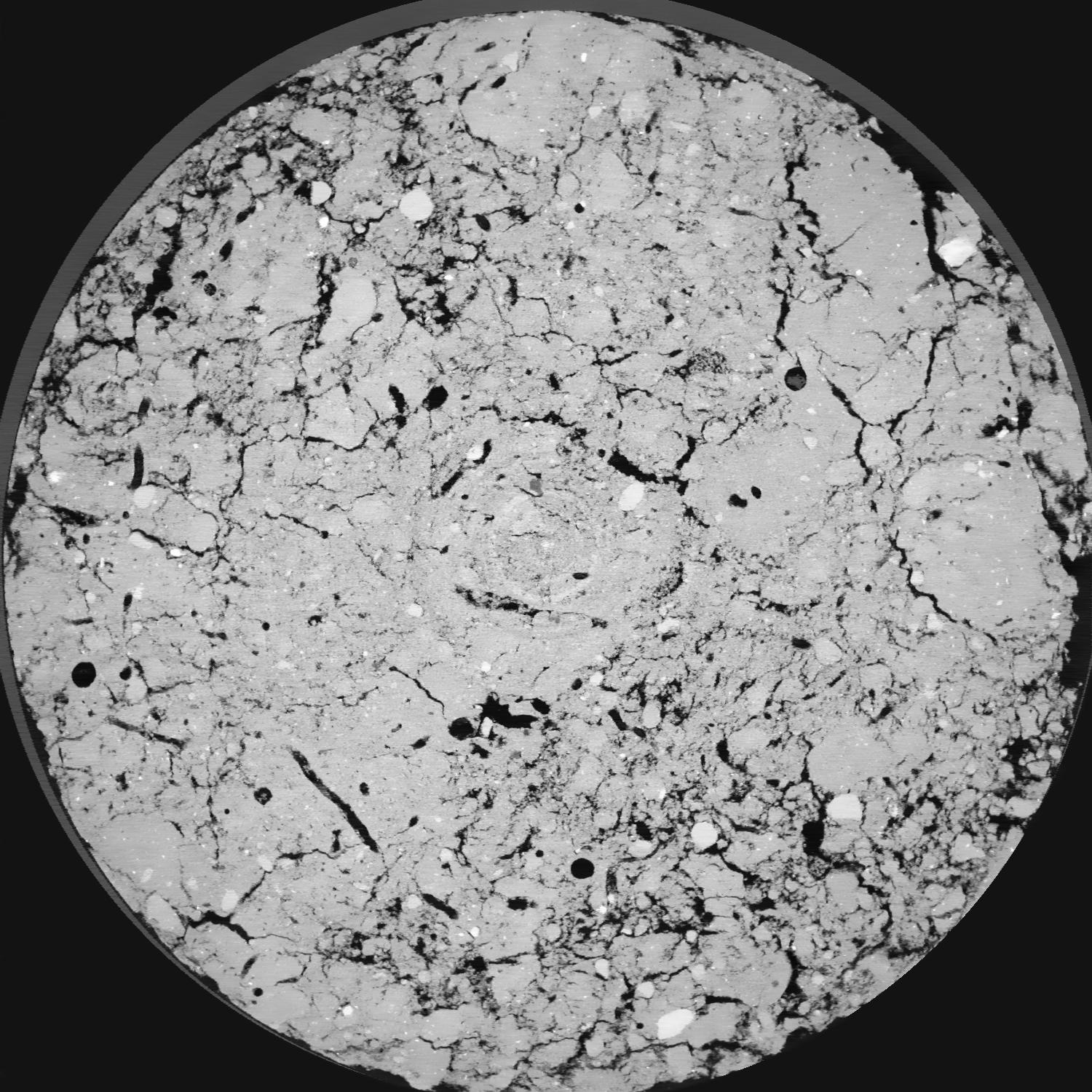
|
|---|
|
| Texture | silt loam |
|---|
| Sand | 8.0 |
|---|
| Silt | 79.0 |
|---|
| Clay | 13.0 |
|---|
|
| Bulk density | 1.41 |
|---|
| org. Carbon | 0.126 |
|---|
| six month after last tillage, field trial running for 25 years, only bottom 300 are dense, top looks as if aggregated |
|---|
| Publication |
|---|
| Binary File Download |
|---|
|
Results
| Porosity | Surface | Mean Curvature | Euler | MeanPoreSize | Gamma | PoreDist |
| 0.08908 | 2.438 | 3.395 | 16.0875 | 0.0 | 0.7936 | 0.136070487 |
| Opening size | Volume | Surface | MeanCurvature | Euler number |
|---|
| 0.04 | 0.08908 | 2.438 | 3.395 | 16.0875 |
| 0.05 | 0.08416 | 1.9855 | 1.98525 | 1.35 |
| 0.06 | 0.07991 | 1.7545 | 1.563 | -0.112275 |
| 0.07 | 0.07671 | 1.609 | 1.3635 | 0.479125 |
| 0.08 | 0.07502 | 1.539 | 1.335 | 1.835 |
| 0.09000000000000001 | 0.06567 | 1.2085 | 0.943 | 0.919775 |
| 0.1 | 0.06163 | 1.086 | 0.82975 | 0.980875 |
| 0.12000000000000001 | 0.05665 | 0.939 | 0.70625 | 1.0411375 |
| 0.13999999999999999 | 0.04687 | 0.692 | 0.48575 | 0.7762 |
| 0.16 | 0.04123 | 0.5665 | 0.383 | 0.615925 |
| 0.18 | 0.03349 | 0.4095 | 0.2545 | 0.461575 |
| 0.19999999999999998 | 0.02999 | 0.3435 | 0.203825 | 0.343375 |
| 0.22 | 0.02435 | 0.2472 | 0.132025 | 0.24295 |
| 0.24 | 0.02182 | 0.2048 | 0.102 | 0.156675 |
| 0.26 | 0.01882 | 0.161 | 0.07315 | 0.11417875 |
| 0.28 | 0.01754 | 0.1423 | 0.0617 | 0.0824625 |
| 0.30000000000000004 | 0.0153 | 0.11295 | 0.043775 | 0.05666625 |
| 0.4 | 0.01047 | 0.05945 | 0.01646275 | 0.01564625 |
| 0.5 | 0.008047 | 0.039865 | 0.00943025 | 0.00803475 |
| 0.6 | 0.006058 | 0.02627 | 0.00549325 | 0.00444025 |
| 0.7000000000000001 | 0.004857 | 0.019235 | 0.0035945 | 0.002325875 |
| 0.9 | 0.003226 | 0.011355 | 0.001860675 | 0.0016915 |
| 1.1 | 0.002111 | 0.00731 | 0.001222125 | 0.000634325 |
| 1.3 | 0.001056 | 0.003789 | 0.0006893 | 0.000422887 |
| 1.5 | 0.0001855 | 0.000661 | 0.000122635 | 0.00007244 |
Reference: An open Soil Structure Library based on X-ray CT data
 Soil Structure Library