General Information
Internal Identifier CG_G3_U_b_3cm_c
| Soil Type | Chernozem |
|---|
| Classification | WRB |
|---|
|
| Location | Bernburg (Westerfeld) |
|---|
| Latitude | 51.820 |
|---|
| Longitude | 11.700 |
|---|
|
| Landuse | agricultural crop rotation |
|---|
| Tillage | reduced tillage |
|---|
| Crop | winter wheat, maize, winter wheat, winter rape, winter barley |
|---|
|
| Sampling Depth | 31.0 |
|---|
| Sample Height | 3.0 |
|---|
| Sampling Date | March 28, 2017 |
|---|
| Voxel size | 0.02 |
|---|
| Pores white? | True |
|---|
|
| XY Plane |
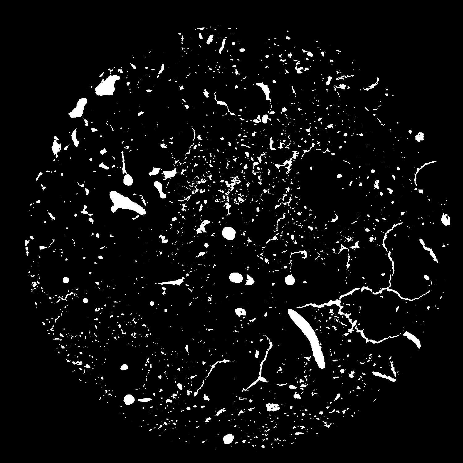
|
|---|
|
| XY Plane Grey |
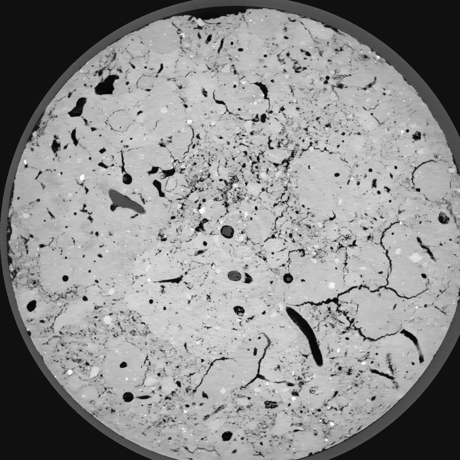
|
|---|
|
| Texture | silt loam |
|---|
| Sand | 8.0 |
|---|
| Silt | 79.0 |
|---|
| Clay | 13.0 |
|---|
|
| Bulk density | 1.41 |
|---|
| org. Carbon | 0.126 |
|---|
| six month after last tillage, field trial running for 25 years,only bottom is dense, same aggregation like in b sample |
|---|
| Publication |
|---|
| Binary File Download |
|---|
|
Results
| Porosity | Surface | Mean Curvature | Euler | MeanPoreSize | Gamma | PoreDist |
| 0.07702 | 2.153 | 3.475 | 21.475 | 0.0 | 0.6405 | 0.13985682 |
| Opening size | Volume | Surface | MeanCurvature | Euler number |
|---|
| 0.04 | 0.07702 | 2.153 | 3.475 | 21.475 |
| 0.05 | 0.07251 | 1.7465 | 2.09075 | 5.07 |
| 0.06 | 0.06878 | 1.536 | 1.644 | 2.7625 |
| 0.07 | 0.06602 | 1.4045 | 1.4265 | 2.70625 |
| 0.08 | 0.06466 | 1.347 | 1.38975 | 3.65 |
| 0.09000000000000001 | 0.05696 | 1.0545 | 0.9475 | 1.895 |
| 0.1 | 0.0538 | 0.9525 | 0.82875 | 1.7 |
| 0.12000000000000001 | 0.04985 | 0.83 | 0.69775 | 1.43375 |
| 0.13999999999999999 | 0.04234 | 0.6275 | 0.4775 | 0.9085125 |
| 0.16 | 0.03802 | 0.5245 | 0.3775 | 0.6876625 |
| 0.18 | 0.03209 | 0.39725 | 0.25775 | 0.4807125 |
| 0.19999999999999998 | 0.02921 | 0.33985 | 0.208825 | 0.344675 |
| 0.22 | 0.02466 | 0.25905 | 0.143575 | 0.2598625 |
| 0.24 | 0.02233 | 0.2192 | 0.1145 | 0.1662375 |
| 0.26 | 0.01945 | 0.17565 | 0.08455 | 0.1272125 |
| 0.28 | 0.0181 | 0.1552 | 0.07145 | 0.090625 |
| 0.30000000000000004 | 0.01574 | 0.1234 | 0.051675 | 0.0651075 |
| 0.4 | 0.0107 | 0.0646 | 0.020054 | 0.02139 |
| 0.5 | 0.00855 | 0.045155 | 0.01147925 | 0.00900625 |
| 0.6 | 0.007002 | 0.03446 | 0.008053 | 0.00469075 |
| 0.7000000000000001 | 0.004133 | 0.016895 | 0.00359125 | 0.004127875 |
| 0.9 | 0.002243 | 0.006595 | 0.000968175 | 0.000562888 |
| 1.1 | 0.001542 | 0.0037935 | 0.0004278 | 0.000375262 |
| 1.3 | 0.001326 | 0.0030935 | 0.000318975 | 0.000069649 |
| 1.5 | 0.001098 | 0.002669 | 0.0002927 | 0.000034824 |
| 1.7 | 0.0006686 | 0.0018575 | 0.000258925 | 0.000069649 |
Reference: An open Soil Structure Library based on X-ray CT data
 Soil Structure Library